Are you searching for treks in the Himalayas that offer breathtaking views without exhausting your legs? The Dayara Bugyal trek deserves your attention.
Many trekkers call it one of the perfect treks in Uttarakhand for beginners. Families, children, and first-time trekkers often choose this route because of its easy level trek and stone-paved path. The region also attracts nature lovers and adventure seekers who want a peaceful weekend adventure in the mountains.
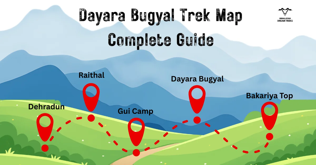
This article explains the Dayara Bugyal trek map, starting from Dehradun to Raithal and then covering the entire trekking route in detail.
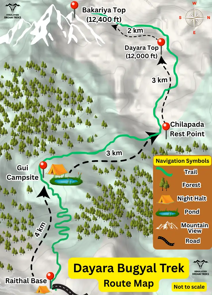
Table of Contents
Dayara Bugyal Trek Location – Raithal, Uttarakhand
Dayara Bugyal is located in the Uttarkashi district of Uttarakhand, India, within the scenic Garhwal Himalayas. This high altitude meadow spreads across the Himalayan terrain and sits above the charming village of Raithal, which is easily accessible by road from major cities like Dehradun and Rishikesh.
The area is part of the high-altitude meadows in the upper region of Uttarakhand. During summer, these natural grasslands come alive with lush green grass and colorful seasonal flowers. When winter arrives, the same meadows transform into a magical winter wonderland, chilly winds, and stunning white landscapes. For this reason, it is considered one of the best winter treks in Uttarakhand Himalayas.
From the meadow, of Dayara, trekkers enjoy a rewarding view of famous Himalayan peaks such as:
- Gangotri I & II
- Janoli
- DKD
- Mt. Srikanth
- Black Peak
- Mt Bandarpunch
Dayara Bugyal Trek Map Explained

The route map of Dayara Bugyal trek usually follows these steps:
Drive from Dehradun / Delhi to Raithal → Gui Campsite → Dayara Bugyal Top or Bakariya Top → Back to Gui → Back to Raithal, and then drive to Dehradun / Rishikesh / Delhi.
The entire trek route take around 3 to 4 days to complete.
Step 1: Dehradun to Raithal Drive
The journey begins from Dehradun and heads toward Raithal, covering a road distance of approximately 183 km.
The scenic drive takes you through the charming towns of Mussoorie and Uttarkashi. Winding forest roads, sparkling rivers, and breathtaking mountain views make the journey as enjoyable as the trek itself.
Travelers can reach Raithal by UTC bus, shared taxi, or private vehicle. Keep in mind that UTC buses only go as far as Uttarkashi, so from there you’ll need to book a taxi, as shared taxis rarely travel directly to Raithal.
Step 2: Raithal to Gui Campsite Trekking
Raithal to Gui Route: This is the first trekking section of the route. The trail gradually climbs from Raithal towards Gui Campsite through the forested mountain terrain. The distance is approximately 4–5 km.
Step 3: Gui to Dayara Bugyal Top / Bakariya Top and back to Gui Campsite [Day-hike]
The next day, trekkers make their way from Gui Campsite to Dayara Bugyal.
You’ll walk through open grasslands, and in winter, the trail is covered with snow, turning the landscape into a magical wonderland. Wide hiking paths make the walk comfortable, and the scenery rewards you at every step.
For those looking to go a bit further, the Bakariya Top is the highest point of the meadow at about 12,400 feet. Bakariya Top is reached by continuing beyond the main Dayara meadow area. This section involves additional elevation gain and is generally included as a day-hike before returning towards Gui Campsite.
By evening, trekkers return to Gui Campsite.
Step 4: Return Journey
Trekkers return via the same route: Gui → Raithal → Dehradun
The descent feels easy and comfortable, even for families and children.
Dayara Bugyal Trek Height and Distance Facts
| Location | Altitude | Coordinates |
| Raithal | 1800 m (5,905 feet) | 30.8125091,78.5736384 |
| Gui Campsite | 2935 m (9,630 feet) | 30.8188296,78.599109 |
| Dayara Bugyal | 11,181 feet and 12,000 feet | 30.8311459,78.5237136 |
| Bakria Top | 3,780 m (12,400 feet) | 30.8228008,78.4895923 |
The trek begins at the lower elevation of Raithal, which sits at around 1,800 meters (5,905 feet) above sea level. This gives trekkers enough time to acclimatize before heading toward the higher altitudes of Dayara Bugyal.
From Raithal, the trail leads to Gui Lake Campsite, located at about 2,935 meters (9,630 feet).
The height of dayara Bugyal ranges between 11,181 feet and 12,000 feet. If you continue further to Bakariya Top, the highest point of the trek, you reach around 12,400 feet (3,780 meters).
Since Dayara Bugyal is not at an extreme altitude, cases of altitude sickness are rare. The slow, gradual ascent and manageable distance make this trek ideal for beginners, families, and first-time Himalayan trekkers.
The Dayara Bugyal trek distance is around 10 km one way from the starting point at Raithal village, with a trail that remains mostly gradual and easy to manage for beginners. If you also visit Bakariya Top, which lies between 2–3 km beyond Dayara Top, the total trekking distance becomes approximately 24 km for the round trip.
Common Navigation Mistakes on the Dayara Bugyal Trek
- Starting the trek without checking the route beforehand.
- Depending completely on mobile network for navigation.
- Taking shortcuts without confirming the trail.
- Confusing campsite locations with the main Dayara meadow.
- Continuing towards Bakariya Top without checking weather and available daylight.
- Ignoring directions given by local guides during snow or poor-visibility conditions.
Conclusion
This Dayara Bugyal trek map provides all the vital information including height, distance, difficulty level, and the trekking route. It clearly explains the journey from Dehradun to Raithal and then across the high-altitude meadows.
The trail suits families, children, beginners, and adventure enthusiasts alike. Its stone-paved paths, wide meadows, and gentle climbs make it one of the best Himalayan treks for new trekkers.
Whether you enjoy snow treks in India, scenic hiking trails, or peaceful journeys in the mountains, Dayara Bugyal offers a balanced mix of adventure and relaxation.
If you are looking for a winter trek or a refreshing summer escape, this meadow is a great choice.
So pack your bags, lace up your boots, and get ready to experience the beauty of the Garhwal Himalayas.


Leave a Comment