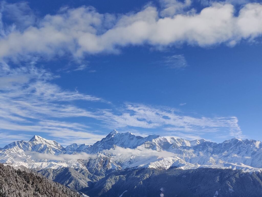
Uttarakhand, also revered as ‘Devbhoomi’ or the ‘abode of the Gods,’ is a beautiful state in north India. It features the heavenly landscapes formed by the Himalayan range spread across its landform. Uttarakhand region boasts of its natural beauty with its Terai grasslands, Savannas, Alpine vegetation, and dense forests. The valleys, gorges, glacial lakes, rustic villages, and ancient temples of Uttarakhand, attract adventurous trekkers and explorers from across the world.
The state highlights the Garhwal Range, Kumaon Range, and some mountains of the Zaskar Range of the great Himalayas. These ranges feature some of the tallest and most dominating peaks of India, here, we will explore the top 12 highest peaks of Uttarakhand based on their height above sea level.
Table of Contents
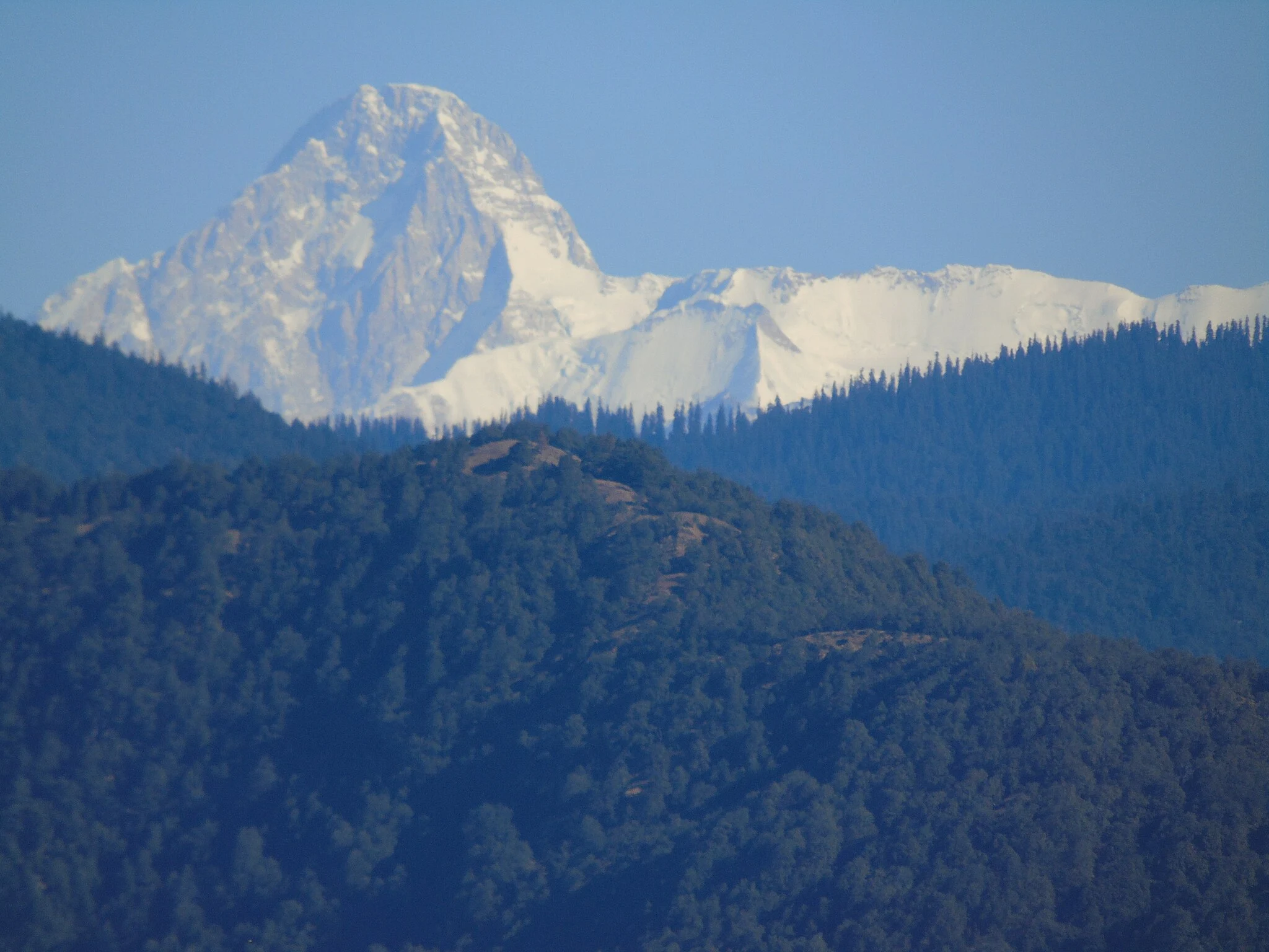
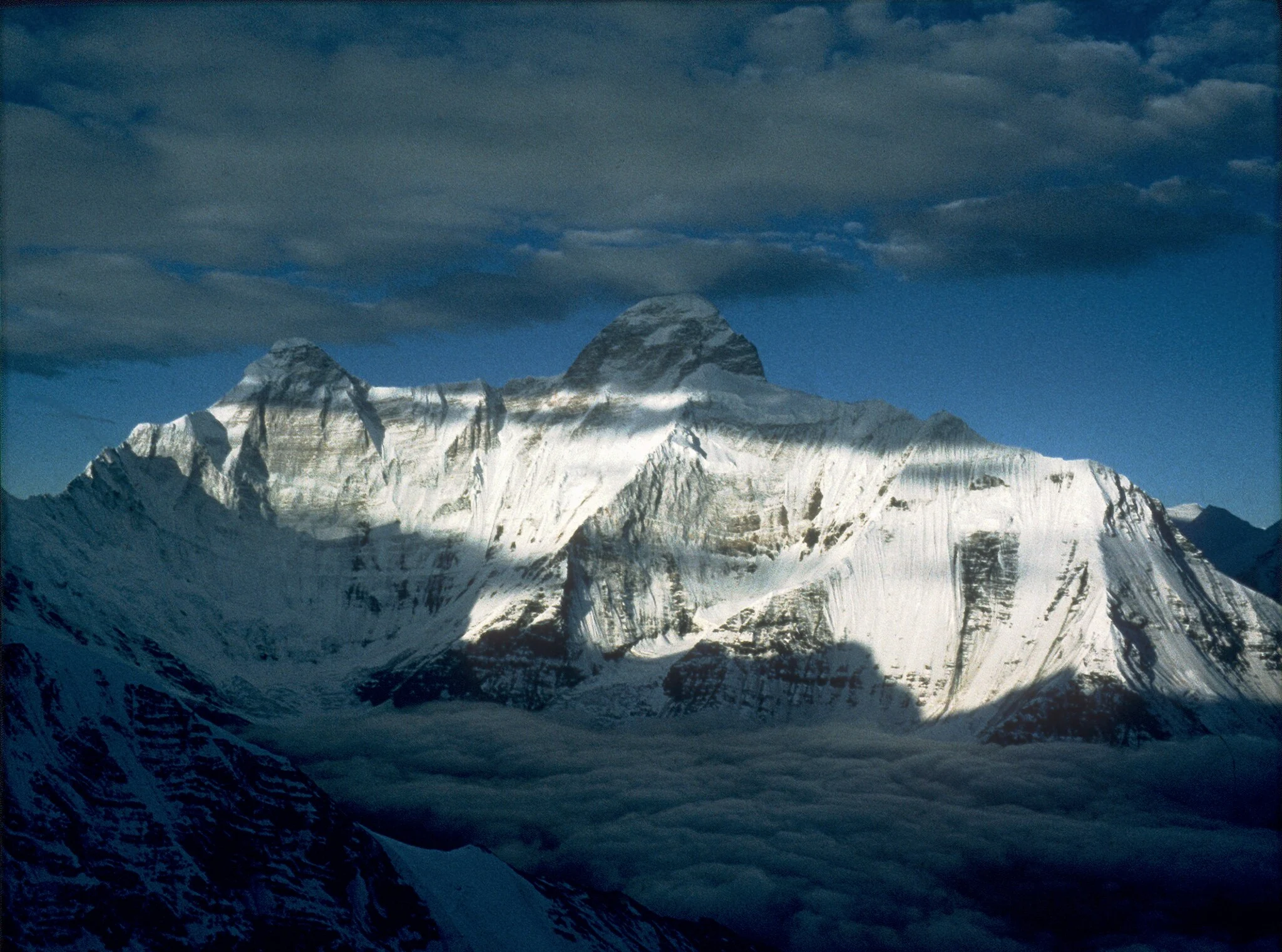
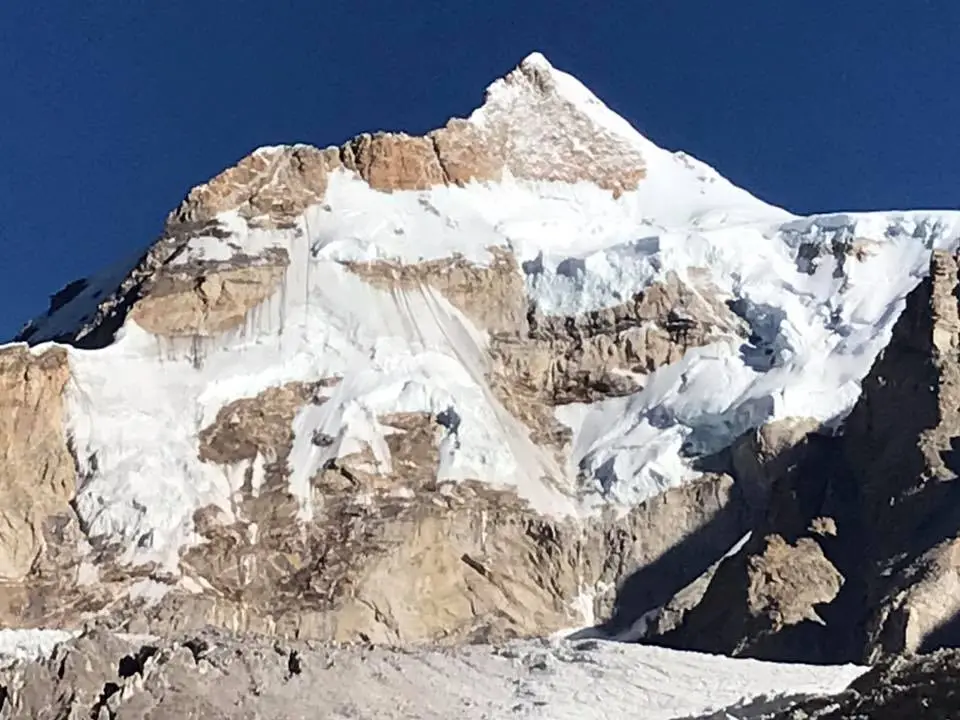
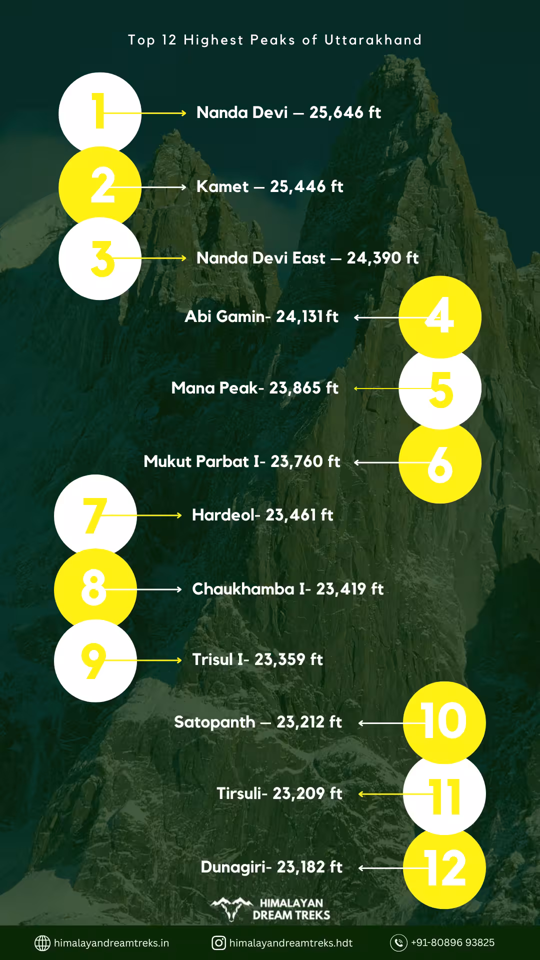
1) Nanda Devi – 25,646 ft
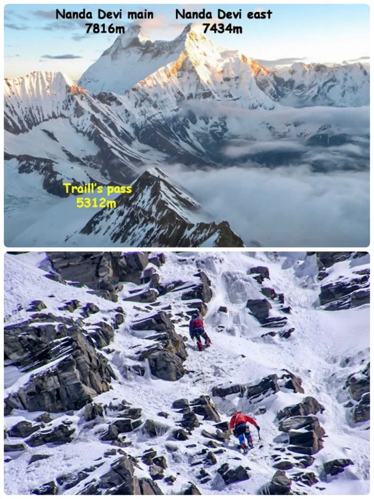

Nanda Devi is Uttarakhand’s highest peak and the second highest in India after Kanchenjunga. It is located in the Chamoli district in the Garhwal Himalayas at a height of 7,817m above sea level. Nanda Devi mountain peak is the highest peak that is located entirely in India.
Geographical Features and Details
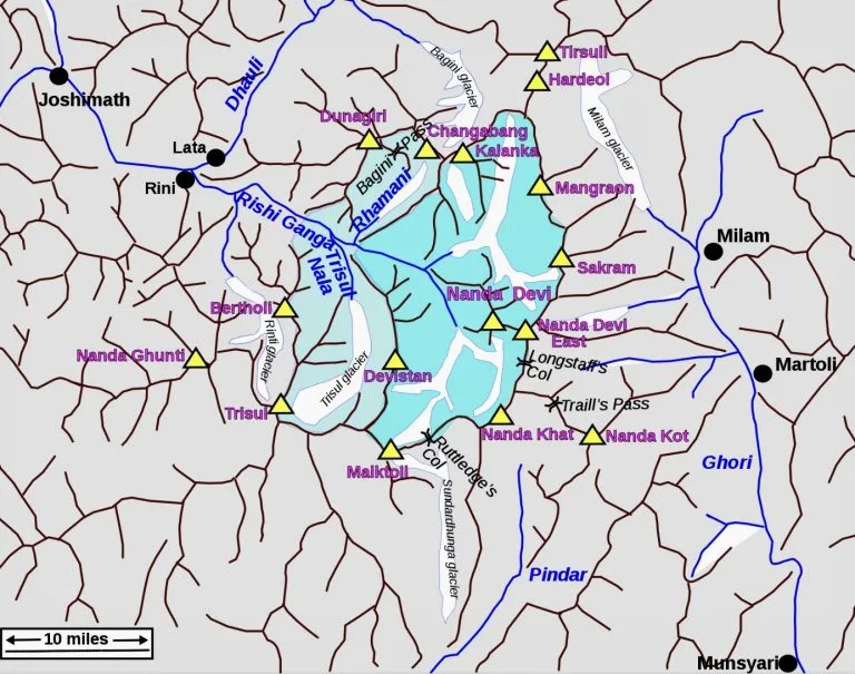
Nanda Devi is situated between the Rishi Ganga Valley to its west and the Ghori Ganga Valley to its east. Nanda Ghunti, known as the “headdress of the goddess Nanda,” leads up to the Nanda Devi peak from the west. It is balanced by Nanda Kot or “the fortress of the goddess Nanda,” to its east.
| Attribute | Details |
| Region | Chamoli District |
| Base | Munsiyari |
| Altitude | 7,817 m/ 25,646 ft |
| Prominence | 3,134 m/ 10,299 ft |
| Best Time to Climb | May-October |
| Expedition Difficulty | Alpine and technical climbing, unpredictable weather, avalanche prone. |
| World Rank | 23rd |
| Nearest Town/City | Joshimath |
Climbing History of Nanda Devi Peak
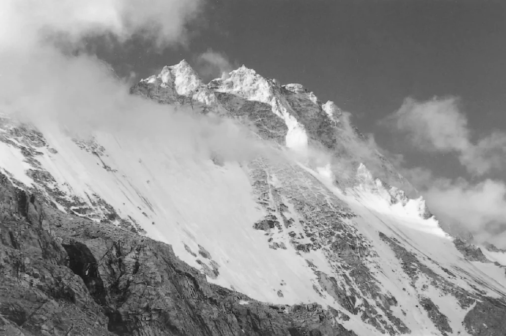
Nanda Devi Mountain is believed to be one of the toughest peaks to climb in the world. Adventurers throughout the peak’s history have made several attempts to climb it.1
- In 1883, W.W. Graham became the first man to attempt the climb but could only reach the outer sections of the sanctuary.2
- In 1905, Dr. Tom Longstaff and the Brocherel Brothers explored the east sanctuary of the Nanda Devi. They reached up to 19,000ft to the Lawan Gad via Milam Valley. Longstaff became the first man to probe the southern and northern inner sections of the Nanda Devi sanctuary by climbing the Trisul peak.
- In 1934, Eric Shipton and H.W Tilman with three Sherpas–Ang Tharkay, Kusang, and Pasang penetrated the southern sanctuary of Nanda Devi. They discovered a passage through Rishi Gorge but could not climb up to the Summit.
- On August 29, 1936, Bill Tilman and Noel Odell, successfully reached the summit of Nanda Devi’s main peak. They approached the mountain from the Rishiganga Valley facing difficult weather and technical climbing challenges. Bill Aitken, in his book The Nanda Devi Affair, compared the beautiful view from the top of Nanda Devi to the “Hindu garden of Eden.”
Nanda Devi National Park
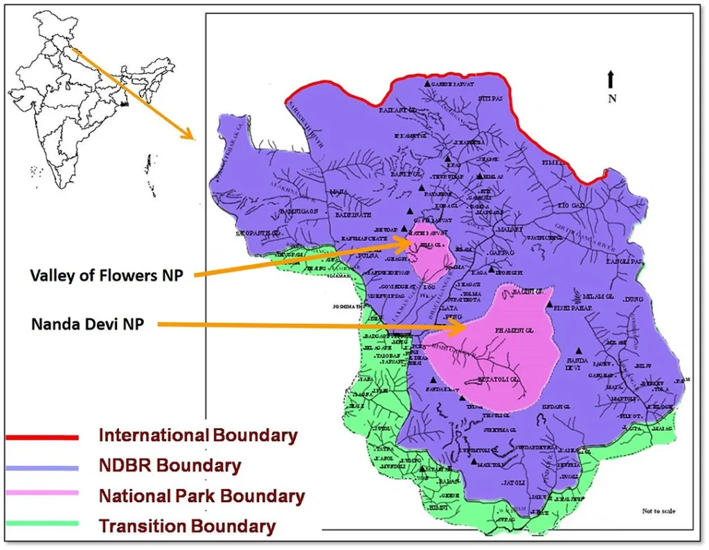
The untouched beauty of Nanda Devi’s circle of mountains serves as a biodiversity hotspot and eco-sensitive zone of Uttarakhand. In 1939, the surrounding region was declared as a ‘sanctuary’ to conserve its natural resources and wildlife habitat. Owing to several human adventure activities, it was declared a protected area under Nanda Devi National Park (NDNP) in 1982.
The special features of the region are:
- UNESCO World Heritage Site: Nanda Devi Biosphere Reserve and Valley of Flowers National Park under NDNP were declared world heritage sites in 1988 and 2000 respectively.3
- Spiritual Significance: Nanda Devi, known as the “bliss-giving goddess,” is a patron deity of the Kumaon and Garhwal locals. They perform the Nanda Devi Raj Jat Yatra every 12 years and the Nanda Devi Mela is celebrated in September every year across Uttarakhand.
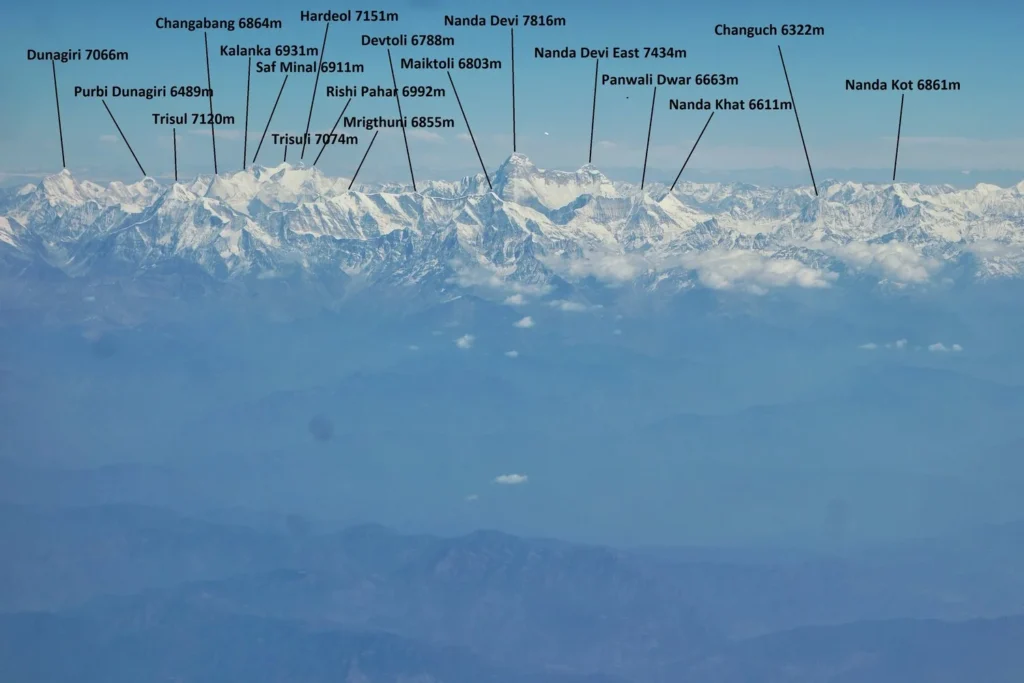
- Visible Peaks: Lata, Jhandidhar, Dunagiri, Kalanka, Rishiparvat, Nanda Devi East, Nanda Khat and Trisul
- Rivers: Alaknanda River, and its tributaries–Rishi Ganga, Dhauli Ganga, Pushwapati, and Khiro Ganga.
- Flora: fir, birch, juniper scrubs, mosses, lichens, rhododendrons, and medicinal plants.
- Fauna: Goral, Himalayan tahr, musk deer, blue sheep, red fox, Himalayan weasel, pika, snow leopard black bear, and common leopard.4
- Birds: Himalayan Monal, Koklas Pheasant, Snow Partridge, Chukar Partridge, Himalayan Snowcock, Snow Pigeon, Himalayan Golden Eagle, and Himalayan Griffon.5
- Popular Attraction and Activities: Valley of Flower Trek, Joshimath, Badrinath, Narspanpatti meadow, eco-tourism of Reni Village where Chipko Movement started, and more.
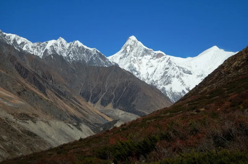
2) Kamet – 25,446 ft
After Nanda Devi, Mt. Kamet is the second-highest peak in Uttarakhand and third highest in India. It is located at a height of 7,756 m in the Chamoli district where the three countries–Tibet, Nepal, and India meet. It is the highest peak of the Zanskar Range in the Garhwal region of the Himalayas.6
Geographical Features and Details
Kamet Mountain resembles a shrine or a pyramid with its plateau-like flat summit with twin peaks. The Paschim or West Kamet Glacier is along the western slopes of Kamet, Abi Gamin, and Mukut Parbat. The eastern side of Kamet and Mana surround the Poorbi or East Kamet Glacier. Raikana Glacier flows into the East Kamet Glacier, draining further into the Dhauliganga River.
| Attribute | Details |
| Region | Chamoli District |
| Base | Niti Village |
| Altitude | 7,756 m/ 25,446 ft |
| Prominence | 2,817 m/ 9,242 ft |
| Best Time to Climb | May-October |
| Expedition Difficulty | High-risk alpine climbing with steep slopes and knife-edged ridges |
| World Rank | 29th |
| Nearest Town/City | Joshimath |
Climbing History of Kamet Peak
The expedition to the summit of Mt Kamet is very challenging due to harsh winds and unfavorable weather at the top of the plateau. Many mountaineers and adventurers gear up to face the challenge of climbing its difficult yet straight ascent, every year.
- In 1912, Mr C. F. Meade discovered the east route to the mountain’s summit, climbing up to 23,500 ft, around two thousand feet less than the summit. ‘Meade’s Col (7,138 m/23,420 ft)’ was named after him and his contribution.
- In 1931, Mr F. S. Smythe used the same route through East Kamet Glacier and Meade’s Col for a successful expedition to the top 25,447 ft. of the Kamet.
Interesting Facts and Special Features:
- The local Tibetans call Kamet with different names like, ‘Kangmen’ or ‘Kangmed’. Mr. Frank Smythe, in his book ‘Kamet Conquered‘, states that Kamet comes from the Tibetan word ‘Kangmed’ which translates to “lower snows”. He describes the beauty of the burning mountains when the sunrays fall over the top of Kamet’s summit.
- The beautiful Vasundhara Lake lies at the base of the Kamet foothill.
- Flora: Himalayan Birch, Mulberry Tree, Deodar, Juniper, and Brahma Kamal.7
- Fauna: Red Panda, Snow Leopard, Himalayan Tahr, and Musk Deer.
- Popular Attractions: Joshimath, Auli, Kuari Bugyal, and Bhavishya Badri Temple
3) Nanda Devi East – 24,390 ft
Nanda Devi Main’s lower summit, at 7,434 m, is called Nanda Devi East and is named after another local goddess, Sunanda Devi. It is the third-highest peak in Uttarakhand, standing tall in the Garhwal Himalayas.
Geographical Features and Details
Nanda Devi East is located to the right of Nanda Devi Main, connected by a 6,667 m high and 2 km long razor-sharp ridge, spanning from east to west. It has Rishi Pahar towards its north, Nanda Ghunti to its west, Nanda Kot to its southeast, and Dunagiri to its northwest.8
The summit can be approached from the southeastern ridge via Puchu Valley, featuring scenic views of the high Gorges and Martoli Village, where Gori Ganga Valley spreads. The trail further leads to Gangar Valley. Nanda Devi East can also be climbed from the eastern side through Munsiyari by Gori Ganga Valley.9
| Attribute | Details |
| Region | Chamoli District |
| Base | Munsiyari |
| Altitude | 7,434 m/ 24,390 ft |
| Prominence | 423 m/ 1,388 ft |
| Best Time to Climb | May-October |
| Expedition Difficulty | Technical alpine climb, steep snow slopes, and sharp ridges |
| World Rank | 60th |
| Nearest Town/City | Joshimath |
Climbing History of Nanda Devi East
The Nanda Devi massif has attracted many venturesome foreign and Indian mountaineers with its alpine climbing and difficult terrains:
- In 1905, Dr. Longstaff with Italian guides Alexis and Henri Brocherel attempted the Nanda Devi East via Puchu Valley in the east. They climbed the Col on its south and reached Lawan Valley instead of the sanctuary. Unwavered, they set on a 2-day ascent towards Nanda Devi Khal and reached 6,400 m on the northeast ridge of Nanda Devi Kot. They had to retreat from here due to an avalanche.
- In 1939, a Polish team of Adam Karpiński summited the Nanda Devi East via southeast ridge and Longstaff Col. The four-member team had Jakub Bujak and Janusz Klarner.
- In 1951 Tenzing Norgay attempted the Nanda Devi East for a French expedition. He climbed the peak and mentioned it as the hardest climb of his career.10
Interesting Facts and Special Features:
- Local legends: The twin peaks of Nanda Devi Main and Nanda Devi East are believed to be royal sisters, Nanda and Sunanda. As per local lores, they fought alongside their father in a battle, later hid behind and transformed themselves into the twin-towering peaks.
- Popular Attractions: Nanda Devi National Park, Valley of Flowers, Nanda Devi Temple, Ghori Ganga Valley.
4) Abi Gamin- 24,131 ft
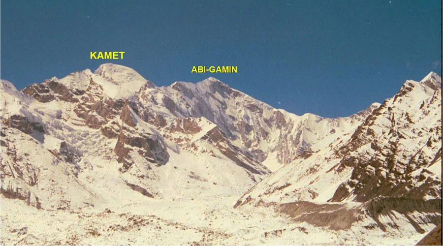
To the northwest of Nanda Devi and 2 km northeast of Kamet, lies the Abi Gamin, the fourth-highest peak of Uttarakhand. Located in the Chamoli district near the Indo-Tibetan border, it boasts a height of 7,355m.11
Geographical Features and Details
Mt. Abi Gabin is connected to Kamet via the saddle of Meade’s Cole.12 The mountain peak comes under the central Himalayan range, marking the concluding point of the Zanskar Range. The summit of Abi Gamin lies on the Tibet border and its northern slope comes under Tibet’s Ngari administrative area. It lies in the drainage area of the upper Alaknanda River and Dhauli River.
| Attribute | Details |
| Region | Chamoli District |
| Base | Mana Pass |
| Altitude | 7,355m/ 24,131 ft |
| Prominence | 237 m/ 778 ft |
| Best Time to Climb | May-October |
| Expedition difficulty | High-risk alpine climbing with steep slopes |
| World Rank | 76th |
| Nearest Town/City | Joshimath |
First Ascent of Abi Gamin
Abi Gamin was named East Ibi Gamin by the Swiss explorers and mountaineers, Schlagintweit brothers.
- In 1855, Adolf and Robert Schlagintweit attempted to climb the summit of Mt. Kamet from the Tibetan side via Mana and Niti Pass.
- They ascended from the Ibi Gamin Glacier, through the northeastern ridge, carving Western Ibi Gamin (Mukut Parbat), Central Ibi Gamin, and Eastern Ibi Gamin.
Interesting Facts and Special Features:
- Mana and Niti Pass mark the conjunction of the Indian and Tibetan borders.
- Flora: Phen Kamal, Juniper, Brahma Kamal, Birch Tree, Deodar, Blue Pine, Fir, and Rhododendrons.
- Fauna: Himalayan Tahr, Himalayan Musk Deer, Red Panda, Snow Leopard, and Black Bear
- Popular Attractions: Joshimath , Kuari Pass Trek, Chopta, Nag Tibba, Auli
5) Mana Peak- 23,865 ft
Mana Peak or Mana Parvat is the fifth-highest peak in Uttarakhand.13 It is located at a height of around 7,273 m in the Chamoli District. The peak is named after the Mana Village of the India-Tibet border, known as the ‘last village of India’. The beautiful village situated on the banks of Saraswati River, is a popular destination for avid trekkers.
Geographical Features and Details
14Mana Peak is located southeast of Kamet Mountain in the Garhwal Himalayas. The scenic pyramid-like peak has a topography of rugged and steep trails of red granite. It can be penetrated through either, the eastern Kamet Glacier or, Banke Glacier and Nagthuni. The peak lies between the Mana and Niti passes, the traditional route between India and Tibet.
| Attribute | Details |
| Region | Chamoli District |
| Base | Mana Village |
| Altitude | 7,273 m/ 23,865 ft |
| Prominence | 768 m/ 2,520 ft |
| Best Time to Climb | May-October |
| World Rank | 91st |
| Nearest Town/City | Joshimath |
First Ascent of Mana Peak
Frank S. Smythe was the first solo mountaineer to ascend the summit of Mana Peak for the first time in 1937.
- In his book, “The Valley of Flowers,” Smythe starts his famous expedition to the Valley of Flowers and attempts to climb the Nilgiri and Rataban Summit.
- He mentions the adverse weather conditions and challenges his team of locals faced during his ascent.
- He carried the steep ascent to the top of Mana Peak solo via the southern approach through Bhyundar Valley and Banke Glacier.
Interesting Facts and Special Features:
- The scenic views from the top of Mana Peak include the ranges of Nepal, the snow-covered peaks of Badrinath, and the ridges of Kulu and Lahul.
- Spiritual Significance: The nearby Mana Village is around 4km from the sacred pilgrimage site of Badrinath.
- Flora: Fir, Pine, Oak, Himalayan Birch, and Deodars
- Fauna: Himalayan Tahr, Snow Leopard, Leopard, and Bear
- Popular Attractions: Neelkanth, Badrinath temple, Vasundhara Falls, Vyas Gufa
6) Mukut Parbat I- 23,760 ft
Resembling a king’s crown, Mukut Parbat I is Uttarakhand’s sixth-highest peak. At an impressive 7,242 m in the Garhwal Himalayas of Chamoli District, it is the 96th-highest peak in the World.15
Geographical Features and Details
Mukut Parbat has Kamet Parbat towards its southeast and Abi Gamin towards its east. Its slopes are drained by Paschim Kamet Glacier and Chamrao Glacier, both fed by the Saraswati River. The mountain range has two peaks: Mukut Parbat I (7,242 m) and Mukut Parbat East (7,130 m).
| Attribute | Details |
| Region | Chamoli District |
| Base | Mana Village |
| Altitude | 7,242 m/ 23,760 ft |
| Prominence | 786 m/ 2,579 ft |
| Best Time to Climb | May-October |
| Expedition Difficulty | Difficult alpine climbing with avalanche-prone and steep slopes |
| World Rank | 96th |
| Nearest Town/City | Joshimath |
First Ascent of Mukut Parbat Peak
A team of Edmund Cotter, Pasang Dawa Lama, and Earle Riddiford from New Zealand were the first mountaineers to reach the summit of Mukut Parbat.16
- In 1951, a team of four mountaineers including Edmund Hillary set out for the expedition of Garhwal Himalayas.
- They started from Ranikhet in Nanda Devi Sanctuary, exploring the trails to Badrinath via Mana Village.
- They further decided to climb the summit of Mukut Parbat which was unexplored. The team, their Sherpa helpers, and Mana porters started from the western ridge of Dakhini Chamrao Glacier.
Interesting Facts and Special Features:
- The scenic views from the top of Mukut Parbat include the blue glaciers of the Tibetan Plateau and the towering peaks of Abi Gamin and Kamet.
- The steep trails of the mountain peak include other subsidiary peaks of Mukut Parbat East and Chamrao Parbat (6,910 m).
- Flora: Rhododendrons, Wild Flowers, Pine, Himalayan Birch, and Deodars
- Fauna: Wild Ass, Snow Leopard, Leopard, and Bear
- Popular Attractions: Badrinath Temple, Nilkantha, Valley of Flowers, Mana Village, Ranikhet
7) Hardeol- 23,461 ft
The seventh-highest peak in Uttarakhand is Hardeol Peak, standing tall at 7,151 m above sea level. The peak is also known as ‘The Temple of Gods’ and ‘Gods’ Abode’ representing its grandeur and beauty. It is located in the region of Kumaon Himalayas in the Pithogarh district.17
Geographical Features and Details
Hardeol is an important peak of the Milam Glacier Valley of the Kumaon Himalayas. It has the peaks Nanda Devi and Rishi Pahar to its south, Tirsuli to its north, Kamet to its northwest, and Nanda Gond to its east.
The eastern, southern, and southeastern sides of Hardeol are tough to climb because of constant dangers like falling ice, steep rocks, and frequent avalanches. The only way to reach the top is from the back of the mountain. But, even this route is very challenging due to the difficult terrain and the risk of icefalls.18
| Attribute | Details |
| Region | Pithogarh District |
| Base | Munsiyari |
| Altitude | 7,151 m/ 23,461 ft |
| Prominence | 1,244 m/ 4,081 ft |
| Expedition Difficulty | High Risk climbing with unpredictable avalanche-prone weather and steep slopes |
| Best Time to Climb | May-October |
| Nearest Town/City | Munsiyari |
Climbing History of Hardeol Peak
The history of the expedition to the Hardeol Peak’s summit has been tragic and challenging:
- In 1939, the first Polish attempt to climb Hardeol faced two casualties, marking a challenging start for the mountain’s ascents.
- In 1964, Lt. Commander M. S. Kohli led an expedition that reached Camp III but abandoned the attempt due to an avalanche.
- In 1965 and 1966 K. P. Sharma and Chanchal Mitra had to give up the ascent due to bad weather.
- In May 1974, an Indo-New Zealand women’s team lost four climbers to an avalanche; however, later in 1975, an I.T.B.P. team established a base camp but faced severe weather challenges that again prevented a successful summit.
- Finally, in 1978, S. P. Mulasi led the I.T.B.P. team’s successful expedition through Munsyari. They crossed the Panchu and Ghangar Villages, reaching the Milam Valley. The team reached the Hardeol Summit through its northwestern ridge.
Interesting Facts and Special Features:
- The mighty peak of Hardeol marks the border of the Chamoli and Pithogarh districts.
- Jowar Bhotiyas: The locals of the Milam Valley or Johar Valley are named after Jowar harvested in the region.
- The peak is called Hardoli or Hardol by the Johar locals and is worshipped as their patron mountain deity.
- Peaks: Tirsuli, Nanda Devi, Rishi Pahar, Tirsuli West, and Purbi Dunagiri.
- Popular Attractions: Betulidhar, Maheshwari Kund, Kalamuni Top, River rafting in Gori Ganga River
8) Chaukhamba I- 23,419 ft
Chaukhamba I is Uttarakhand’s eighth-highest peak, located at 7,138m at the border of Uttarkashi, Chamoli and Rudraprayag district. It is one of the most prominent peaks of the Garhwal Himalaya’s Gangotri Group.
Geographical Features and Details
Chaukhamba massif translates to “four pillars” due to its four major summits, Chaukhamba I (7,138m), II (7,088 m), III (6,995 m), and IV (6,854 m). These four peaks form the south and east boundary of the Gangotri Glacier. Chaukhamba I lies on the northeastern end of the massif.19
The mountain stands above the Gangotri Glacier, Bhagirath Kharak Glacier, and Satopanth Glacier. These glaciers form part of the headwaters of the Ganga River–Bhagirathi, Alakananda and Mandakini. sources
| Attribute | Details |
| Region | Rudraprayag/Uttarkashi/Chamoli District |
| Base | Mana Pass |
| Altitude | 7,138 m/ 23,419 ft |
| Prominence | 1,596 m/ 5,236 ft |
| Expedition Difficulty | High Risk and prone to avalanches |
| Best Time to Climb | May-October |
| Nearest Town/City | Joshimath |
Climbing History of Chaukhamba I Peak
Many mountaineers have attempted to climb the towering peaks of Chaukhamba. It took several failed attempts in 1938 and 1939 for explorers to finally penetrate the summit in 1952:
- In 1912, C.F. Meade reached the col between Chaukhamba I and Januhut via the Bhagirath Kharak glacier in just seven hours but could not cross it.
- In 1934, Eric Shipton and Christiaan Barnard Tilman attempted to carve a trail from Badrinath to Kedarnath. They started via Satopanth Bamak and Satopanth Col but were lost in the Gondharpongi forest for ten days.
- In 1939, Andre Roch and his team attempted the summit via Gangotri and entered Kosa Glacier, climbing to Ghori Parbat. They conquered Ratanban Peak but could not finish the Chaukhamba attempt due to an avalanche.
- In 1952, Swiss members of a French expedition, Lucien George and Victor Russenberger successfully climbed the peak of Chaukhamba I via its northeast face. source
- 1998: Martin Moran completed the Badrinath to Kedarnath crossing following Shipton’s intended route.source
Interesting Facts and Special Features:
- Spiritual Significance: The peak lies west of the famous Hindu pilgrimage site of Badrinath Temple. It overlooks the revered Gangotri Glacier.
- Visible Peaks: Kedarnath Dome, Nilkantha, Nanda Devi, Satopanth, and Bhagirathi peaks.
- Flora: Alpine Vegetation with Himalayan Birch, Mosses, Pines, Deodars, Blue Poppy, and Bugyal Shrubs.
- Fauna: Bharal, Goral, Himalayan Tahr, Red Fox, Musk Deer, Snow Leopard, Himalayan Weasel, and Brown Bear.
- Birds: Kalij, Kokla, Chir, Monal, Himalayan Snow Cock, Kala Titar, Chakor, and Harial.
Popular Attractions: Kyunkaleshwar Mahadev Temple, Deoriatal Trek, Satopanth Lake Trek
9) Trisul I- 23,359 ft
The ninth-highest peak of Uttarakhand is Trisul I, positioned at a height of 7120 m. The Trisul massif is located in the western Kumaon region, with its three summits spread across Bageshwar and Chamoli districts. The three summits Trisul I, II, and III form a beautiful landscape, resembling the trident or Trisul of Lord Shiva, rightly earning their name.
Geographical Features and Details
The three peaks of Trisul form a north-south ridge, with the tallest Trisul I on the northern end and Trisul III (6,008 m) on the southern. Trisul Glacier lies between Trisul I and Trisul II. The three peaks form a scenic landscape, visible from Kasauni, Ranikhet, Nandakini Valley, Roopkund, and Bedni Bugyal.20
The Trisul I is one of the most prominent peaks in the Nanda Devi Sanctuary, marking its western boundary. It has Nanda Ghunti towards its northwest, Rudugaira towards the west, Mrigthuni to the southeast, and Dunagiri towards its northeast.
| Attribute | Details |
| Region | Chamoli and Bageshwar District |
| Base | Hom Kund |
| Altitude | 7,120 m/ 23,359 ft |
| Prominence | 1,607 m/ 5,272 ft |
| Expedition Difficulty | High Risk, prone to avalanches, and rock falls |
| Best Time to Climb | May-October |
| Nearest Town/City | Auli and Joshimath |
Climbing History of Trisul I Peak
Known for its imposing presence, Trisul I saw early attempts at its summit, drawing the interest of climbers eager to conquer its challenging ascent:
- In 1907, Tom Longstaff and his team reached the summit of Trisul I for the first time. The peak was named Longstaff Mountain after his success in breaking the record of traversing the highest altitude in the world at that time.
- In 1951, Gurdial Singh and Roy Greenwood, a physical training instructor at the Indian Military Academy climbed Tirsul Peak’s summit, inspiring many mountaineers in India.
- In 1978, a team from Japan used the trail from the Trisul Bank to climb the summit of Trisul I from the southern ridge.
- Since then, many adventurers and mountaineers have attempted the Trisul I peak from either north via Nanda Devi Sanctuary (easy) or west (challenging) followed by a ski descent.
Interesting Facts and Special Features:
- Spiritual Significance: The Trisul Peak resembles the mighty weapon of Lord Shiva and is considered sacred by the locals and the pilgrims. The trident signifies his power in creating, preserving, and destroying all three worlds (tri-lokas).
- Visible Peaks: Nanda Devi, Nanda Ghunti, Devasthan I, Devasthan II, Devi Mukut, Devtoli, Hathi Parvat, and Mrigthuni.
- The mysterious lake of Roopkund lies at the foothills of Trisul Peak.
- Flora: Alpine Vegetation with Himalayan Birch, Juniper, and Brahma Kamal.
- Fauna: Bharal, Himalayan Tahr, Seral, Snow Leopard, and Brown Bear.
- Popular Attractions: Roopkund Trek, Nanda Devi Biosphere Reserve, Auli.
10) Satopanth – 23,212 ft
Satopanth Peak is the tenth-highest peak of Uttarakhand, dominating a series of six-thousanders of Garhwal Himalayas at a height of 7,075m. It is located in Uttarkashi District and comes under the premises of Gangotri National Park.
Must Read: National Parks of Uttarakhand
Geographical Features and Details
Satopanth Peak marks the end of the bend of Gangotri Glacier. Its summit resembles the shape of a trapezium with two horizontal tops of 7075m and 7045m joined by a 500-700m ridge running from west to east.21
Satopanth Peak lies south of the Kalindi Pass and Arwa Tal, east of the Vasuki Parvat, west of Bhagirathi Kharak Glacier, and northwest of Chaukhamba Peaks. Alaknanda River originates near the Satopanth bank and joins the Bhagirathi River at Devprayag, feeding the headwaters of the Ganga.
| Attribute | Details |
| Region | Uttarkashi District |
| Base | Gangotri |
| Altitude | 7,075 m/ 23,212 ft |
| Prominence | 1,058 m/ 3,471 ft |
| Expedition Difficulty | Technical, high-angled snow slopes, knife-edge ridge |
| Best Months to Visit | May-October |
| Nearest Town/City | Gangotri/Badrinath |
Climbing History of Satopanth Peak
Satopanth Peak and its beautiful glacier have inspired many mountaineers and explorers to attempt an expedition to its summit:
- In 1938, an Austrian team attempted the peak for the first time via its northeast and northwest ridges but failed.
- It took almost 8 years, in 1947 to successfully reach the summit of Satopanth by Swiss mountaineer, André Roch. He attempted the climb northeast from Chaturanga Glacier, reaching Sundar Bamak, around the edge of Vasuki Parvat reaching the north face of Satopanth.
- In 1982, the peak was opened to foreign climbers. Japanese mountaineer J. Toya conquered the peak of Satopanth via the north.
- In 1986, a Polish team penetrated the summit’s south face via Swachchand Bamak for the first time. Sources
Interesting Facts and Special Features:
- Spiritual Significance: Satopanth Peak translates to ‘mountain of good path or good faith,” and finds a mention in the Kedar Khand of Skand Puran. The Marchas of Mana village worships the Satopanth Glacier, 2.8 km from Badrinath. They believe that the lake leads to the path of salvation.
- Visible Peaks: Kamet, Mukut, Mana, Chaukhamba, Bhagirathi series, Thalaysagar, and Shivling
- Flora: Cedar, Pine, Birch, Blue Poppy, Rhododendrons, Wild Flowers, and Brahma Kamal.
- Fauna: Red Fox, Bharal or Blue Sheep, Snow Leopard, Black Bear, Brown Bear, and Pika.
- Popular Attractions: Gaumukh, Tapovan, Nandanvan, Vasuki Tal, and Satopanth Glacial Lake.
11) Tirsuli- 23,209 ft
The eleventh-highest peak in Uttarakhand is Tirsuli Peak, also known as Tirsuli I or Tirsuli Main. The peak stands at a towering height of 7,074 m, spread across Pithogarh and Chamoli districts. It is a part of the Zaskar Range of the Kumaoni Himalayas.
Geographical Features and Details
Trisuli Peak lies at the head of Milam Valley, the northern end of Johar Valley, and forms the eastern boundary of Nanda Devi Sanctuary. The mountain group includes some of the prominent peaks of Tirsuli West, Hardeol (Tirsuli South), Dunagiri, Changbang, and Kalanka. Tirsuli is the northeasterly neighbor of Hardeol, these tall peaks are connected through a long ridge.
| Attribute | Details |
| Region | Pithogarh and Chamoli District |
| Base | Munsiyari |
| Altitude | 7074 m/23,209 ft |
| Prominence | 684 m/2,244 ft |
| Expedition Difficulty | High-risk, avalanche-prone, steep slopes |
| Best Time to Climb | May-October |
| Nearest Town/City | Joshimath |
Climbing History of Tirsuli Peak
Trisuli is one of the captivating mountains visible from the popular trails of Nanda Devi. It has attracted many foreign and Indian mountaineers with a rich history of ascents:22
- In 1939, a Polish team attempted to reach the summit of Tirsuli but met with a devastating end with two climbers dying at C3 due to an avalanche.
- In 1964, Capt, Kohli of the Indian Mountaineering Foundation and his team had another failed attempt owing to the avalanche.
- In 1965, the Tirsuli summit saw another unsuccessful attempt by K.P. Sharma and his team of the Himalayan Association. They turned back after reaching a height of 5,500 m.
- In 1966, Chanchal Mitra and his team from the Himalayan Association, Kolkata became the first climbers to conquer the difficult peak of Tirsuli. They started from the east side of the southeast ridge, followed by another southeast ridge to reach the top.
Interesting Facts and Special Features:
- Spiritual Significance: Tirsuli I, Tirsuli West, and Tirsuli South (Hardeol) are sacred mountains that resemble the three spikes of Trishool or Trident of Lord Shiva. The region of Gori Valley from Munsiyari to Milam called Johar is dotted with small villages, where Jowar/Johar Bhotiyas worship the mountains as their patron deities.
- Visible Peaks: Nanda Devi East, Nanda Kot, Martoli, Nital Thaur, Kholi, and Rishi Pahar.
- Glaciers: Milam Glacier, Ikualary Glacier, Tirsuli Glacier.
- Popular Attractions: Milam Valley, Johar Valley, Ghori Ganga River rafting, Joshimath, Nanda Devi Sanctuary
12) Dunagiri- 23,182 ft
Dunagiri, also known as Dronagiri, is Uttarakhand’s twelfth-highest peak. The lofty peak is located at 7,066 m in the Kumaon Himalayas in Chamoli district. Dunagiri is popular among bold mountaineers for its technical climb and scenic views from the top.23
Geographical Features and Details
The Dunagiri Peak lies northwest of Nanda Devi, Bagini Glacier is towards its northeast, Trisul to its south, and Kamet to its northwest. It has peaks like Hathi Parbat, Satopanth, and Gangotri to the west and Changabang to the northeast.24
The peak stands tall between the Milam and the Dhauli Valley, where the Dhauli and Rishi Ganga Rivers meet. The climb to the peak leads up to Rishi Valley and further to Rhamani Glacier at 16,500 ft.
| Attribute | Details |
| Region | Chamoli District |
| Base | Lower Bagni Kharak |
| Altitude | 7,066 m/23,182 ft |
| Prominence | 1,291 m/4,236 ft |
| Expedition Difficulty | Iced knife-edge ridge, steep snow, and ice slope |
| Best Time to Climb | May-October |
| Nearest Town/City | Joshimath |
Climbing History of Dunagiri Peak
The peak is a popular climbing destination among seasoned mountaineers due to its proximity to the Nanda Devi sanctuary and the Valley of Flowers. Its rich climbing history has witnessed many legendary mountaineers from across the world:
- In 1883, W.W. Graham and Emil Boss made their very first attempt at the summit of Dunagiri. They took the southern ridge or Hanuman Ridge and reached the summit of Changbang mountain at 22,700 ft, confusing it with Dunagiri.
- Between 1905 and 1907, Dr. Longstaff studied the Dunagiri Peak and other nearby mountain ranges, exploring their trails and ridges.
- In 1936, Shipton and Angtharkay made another unsuccessful attempt at the Dunagiri Summit, turning back from 1,000 ft below the summit.
- In 1937, Smythe and Oliver attempted the ascent of Dunagiri via Rishi Valley and Rhamani Glacier. They covered one-third of the mountain and had to halt the climb due to bad weather during the monsoons.
- In 1939 Swiss mountaineers Andre Roch, F. Steuri, and D. Zogg made the first successful attempt. They followed the same route of Smythe and Oliver via southwest-ridge,
Interesting Facts and Special Features:
- Spiritual Significance: Dunagiri Peak is popular for the Shakti temple, Dunagiri Devi Temple. During the Ramayana, it is believed that Lord Hanuman brought Sanjeevani Herb to save Lakshman by carrying the Dunagiri Parvat. Shree Dronacharya, the guru of Pandavas, practiced tapasya and meditated on this peak.25
- Mention in Skanda Purana: Dunagiri is mentioned in the Manaskhand of Skand Purana, it is revered as Brahma Parvat (divine mountain). It is believed to be the most ancient Siddha Shaktipeeth influenced by Shaiva, Vaishnava, and Shakti sects of Hinduism.
- Visible Peaks: Trisul, Nanda Devi, Hardeol, Changbang, and Kalanka.
- Flora: Monkshood, Juniper, Primulas, Berberies, Anemones, Birch, and Alpine Shrubs.26
- Fauna: Black Bear, Snow Leopard, Mules
- Popular Attractions: Dunagiri Devi Temple, Almora, Kasauni, Binsar Mahadev Temple, and Someshwar
Conclusion
The beautiful Himalayan state of Uttarakhand features some of the highest seven-thousanders and six-thousanders in the country. The twelve highest peaks of Uttarakhand are Nanda Devi, Kamet, Nanda Devi East, Abi Gamin, Mana, Mukut Parbat, Hardeol, Chaukhamba I, Trisul I, Satopanth, Tirsuli, and Dunagiri. These mighty Himalayan mountains are famous for their panoramic landscapes and are often worshipped as local deities. Their climbing history shows that despite the difficult terrains, many strong-willed mountaineers have conquered them with unwavering resilience and grit.
References
- https://explorersweb.com/nanda-devi/ ↩︎
- https://www.nature.com/articles/134731b0.pdf ↩︎
- https://en.unesco.org/silkroad/silk-road-themes/biosphere-reserve/nanda-devi ↩︎
- https://wii.gov.in/images/images/documents/unesco_c2c_nandadevi_exp_2001.pdf ↩︎
- https://datazone.birdlife.org/site/factsheet/nanda-devi-biosphere-reserve-iba-india ↩︎
- https://en.wikipedia.org/wiki/Zanskar#:~:text=The%20Zanskar%20range%20spans%20640,highest%20point%20in%20the%20range. ↩︎
- https://bsi.gov.in/uploads/documents/Public_Information/publication/books/district_flora/Flora%20of%20Chamoli.pdf ↩︎
- https://www.peakbagger.com/peak.aspx?pid=35647 ↩︎
- https://www.himalayanclub.org/hj/70/9/nanda-devi-east-75-years-on-a-journey-through-the-past/ ↩︎
- https://www.mef.org.uk/uploads/uploads/MEF-15-20.pdf ↩︎
- https://books.google.co.in/books?hl=en&lr=&id=6C6DGU73WzsC&oi=fnd&pg=PA33&dq=Abi+gamin&ots=Dv2U6xBvE8&sig=jTnA9nCXu0_Emq56xvXoxY7EbQw&redir_esc=y#v=onepage&q=Abi%20gamin&f=false ↩︎
- https://www.peakbagger.com/peak.aspx?pid=18701 ↩︎
- https://peakvisor.com/peak/mana-peak.html#:~:text=Nanda%20Devi%20is%20the%20highest,Nagthuni%20and%20Banke%20Kund%20glacier ↩︎
- https://www.himalayanclub.org/hj/49/18/expeditions-and-notes-49/#point12 ↩︎
- https://mountaineering.uk.gov.in/mukut-parbat ↩︎
- https://www.himalayanclub.org/hj/56/10/first-ascent-of-mukut-parvat-east-1999/ ↩︎
- https://www.himalayanclub.org/hj/45/11/giant-subdued-hardeol-1978/ ↩︎
- https://books.google.co.in/books?hl=en&lr=&id=KptmxrqhKl4C&oi=fnd&pg=PA9&dq=hardeol+peak&ots=znPgpr3NTD&sig=hXoMsWCuWDF5yc7WBf1mykeV2j8&redir_esc=y#v=onepage&q=hardeol%20peak&f=false ↩︎
- https://www.himalayanclub.org/hj/61/12/chaukhamba-the-mountain-on-the-far-horizon/ ↩︎
- https://www.himalayanclub.org/hj/69/5/trisul-the-west-ridge/ ↩︎
- https://www.himalayanclub.org/hj/54/8/satopanth-the-mountain-of-good-faith/ ↩︎
- https://www.himalayanclub.org/hj/27/5/the-first-ascent-of-tirsuli/ ↩︎
- https://archive.org/details/in.ernet.dli.2015.351345/page/n263/mode/2up?q=dunagiri ↩︎
- https://www.himalayanclub.org/hj/12/4/dunagiri-gauri-parbat-rataban-and-chaukhamba-1939/ ↩︎
- https://books.google.co.in/books?id=gp1IDwAAQBAJ&pg=PT192&dq=dunagiri&hl=en&newbks=1&newbks_redir=0&sa=X&ved=2ahUKEwj2-f-Ps7GIAxV4dfUHHVF3C7wQ6AF6BAgJEAI#v=onepage&q&f=false ↩︎
- https://books.google.co.in/books?id=rTlJqiEU3g8C&pg=PA26&dq=dunagiri&hl=en&newbks=1&newbks_redir=0&sa=X&ved=2ahUKEwj2-f-Ps7GIAxV4dfUHHVF3C7wQ6AF6BAgFEAI#v=onepage&q=dunagiri&f=false ↩︎
Leave a Comment