Technology has changed the way we travel and trek. Today, a smartphone can help you find trails, track your route, check elevation and even warn you when you go off-track.
For trekkers heading into the Himalayas, hiking apps can be extremely useful, if used the right way. Well known hikings apps like All Trails, Gaia GPS, onX Backcountry, Cal Topo, and Komoot are considered best for Hiking and Trekking Trails.
In this guide, we break down the best hiking apps, how they work, where they help, where they fail and how Himalayan trekkers should actually use them safely.
Important Disclaimer: Hiking apps are helpful tools, but you should never rely only on a mobile app while trekking in remote Himalayan terrain. Always carry physical maps, follow local guides and use safety equipment.
Table of Contents
What exactly are hiking apps and how do they work?
At their core, hiking apps are digital tools that combine maps, GPS technology, and user-generated data to help people explore the outdoors more confidently. Most apps work by using your phone’s GPS to track your location in real time, even when there is no mobile signal (as long as maps are downloaded offline). They rely on a mix of official map data, satellite imagery, and information shared by other hikers. Over the years, these apps have evolved beyond simple navigation tools.
Best Hiking Apps of 2025
After reviewing multiple apps used by hikers worldwide, here are the most useful hiking apps, especially relevant for Indian Himalayas.
Gaia GPS
Gaia GPS is a powerful navigation-focused hiking app designed for serious outdoor users. Unlike trail-discovery apps, Gaia GPS focuses on maps, terrain, and navigation precision rather than crowdsourced trail reviews. It offers a wide range of map layers, including topographic, satellite imagery, slope angle shading, and terrain data, making it especially useful in mountainous regions. Premium variant available at $4.99 per month.
Pros
- Highly detailed topographic maps
- Excellent for off-trail and remote navigation
- Supports multiple map layers and GPX files
- Works fully offline
- Trusted by professional guides and mountaineers
- Both iOS and Android apps are available.
Cons
- Steeper learning curve for beginners
- Best features require a paid subscription
- The interface may feel overwhelming for casual hikers
Why I like it: Gaia GPS is one of the most reliable apps for understanding the Himalayan terrain. If you are trekking in remote regions where marked trails are limited or constantly changing due to landslides or weather, Gaia’s detailed topographic data helps you make informed decisions. The ability to download maps for offline use and layer different data types gives trekkers a clearer picture of ridgelines, valleys, and elevation changes. Many professional mountain guides rely on Gaia GPS as a backup navigation tool.
Who is it good for? Gaia GPS is ideal for experienced trekkers, explorers and mountaineers heading into less-traveled Himalayan regions. It works best for those who already understand map reading and want deeper terrain insights rather than simple trail directions.
Who shouldn’t use it: If you are a beginner looking for easy trail recommendations, photos, and reviews, Gaia GPS may feel too technical. Casual hikers are better off with simpler apps like AllTrails.
CalTopo
CalTopo is a highly specialized navigation app originally designed for professionals working in rugged terrain. It offers some of the most detailed map data available, including slope angles, sun exposure, and terrain shading. While it may not look visually polished, it is extremely powerful. It’s best used over a Laptop or Desktop for full capability.

Pros
- Extremely detailed topographic and terrain maps
- Advanced route planning and drawing tools
- Popular among search-and-rescue teams
- Strong offline capabilities
- Features like Snow Depth, Daily Satellite, Water Gauge, Slope Angle, and Public Lands.
- Multiple membership options are available at $20 per year, $50 per year, and $100 per year.
Cons
- Complex interface
- Not beginner-friendly
- Limited community trail discovery features
Why I like it: CalTopo excels in planning and risk assessment. For Himalayan treks involving steep ascents, snow sections, or avalanche-prone zones, the slope angle and terrain analysis features are incredibly useful. It allows trekkers to plan routes in advance with a deep understanding of elevation and exposure, which can be critical in high-altitude environments.
Who is it good for? CalTopo is best suited for advanced trekkers, expedition planners, and professional guides who need precise terrain data. It is particularly valuable for those trekking in challenging or technical Himalayan regions.
Who shouldn’t use it: If you want a simple, user-friendly app for discovering hikes or following popular trails, CalTopo is not the right choice. The app assumes a level of navigation knowledge that beginners may not have.
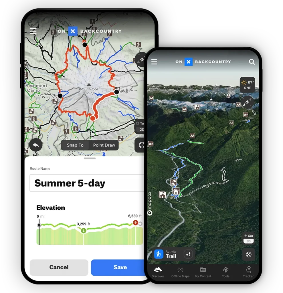
onX Backcountry
onX Backcountry is a navigation and terrain-awareness app that focuses more on where you are and what surrounds you, rather than guiding you through popular hikes. While it is widely used in the US, some of its terrain features are still useful for Himalayan trekkers. Premium is available at $29.99 per year and $99.99 per year.
Pros
- Strong GPS tracking and offline maps
- Detailed terrain and slope visualization
- Useful for understanding land boundaries
- Good situational awareness tool
Cons
- Limited Indian trail data
- More useful as a secondary app
- Not designed for trail discovery
Why I like it: onX Backcountry works well as a support app. The slope shading and terrain views help trekkers understand steepness and surrounding land features, which can be useful in mountainous regions. It’s not a primary navigation tool for the Himalayas, but it adds an extra layer of situational awareness when combined with other apps.
Who is it good for? This app is best for experienced trekkers who already use another navigation app and want additional terrain insight. It works well as a backup or secondary reference tool.
Who shouldn’t use it: If you are looking for trail recommendations, community reviews, or beginner-friendly navigation, onX Backcountry will feel limited.
AllTrails (Best Community-Based Hiking App)
AllTrails is one of the most widely used hiking apps globally and is especially popular for finding established and well-known trekking routes. The app focuses heavily on community input, making it a useful tool for understanding what a trail is actually like before stepping out.

Pros
- Huge database of established trekking routes
- Crowdsourced reviews, photos, and trail updates
- Easy GPS tracking for navigation
- Beginner-friendly interface
- Works well for planning before a trek
Cons
- Offline maps require a paid plan
- Not ideal for off-trail or remote exploration
- Some trail data can be outdated in changing terrain
Why I like it: AllTrails makes trek planning simple. You can quickly see trail distance, elevation gain, difficulty level and recent reviews from other trekkers. Photos uploaded by users give a realistic idea of trail conditions, especially helpful in the Himalayas, where weather and terrain can change rapidly. For beginners and first-time trekkers, AllTrails removes a lot of uncertainty by showing what to expect on a popular route.
Who is it good for? AllTrails is ideal for beginners, families, and trekkers sticking to marked and popular Himalayan trails. If you want to explore known routes without getting into technical navigation, this app works well.
Who shouldn’t use it: It’s not reliable for off-trail exploration or remote Himalayan terrain where routes change often. Advanced trekkers and mountaineers should use more detailed navigation apps alongside it.
Komoot
Komoot is a planning-focused outdoor navigation app known for its clean design and smart route suggestions. Instead of relying heavily on user reviews, it emphasizes route structure, elevation changes, and terrain type.

Pros
- Excellent route planning and navigation
- Clear elevation profiles and surface details
- Works well for hiking, biking, and trail running
- Offline maps available for purchased regions
Cons
- Limited trail data in some Himalayan regions
- Less community feedback compared to AllTrails
- Best features require paid maps
Why I like it: Komoot is great for understanding how physically demanding a trek might be. Its elevation graphs and surface information help trekkers prepare better, especially for long Himalayan walks where endurance matters. The app also works well for creating custom routes, making it useful for trekkers who want flexibility rather than predefined trails.
Who is it good for? Komoot suits trekkers who like planning their route in advance and want clear elevation insights. It’s a good option for moderate-level trekkers exploring semi-popular Himalayan regions.
Who shouldn’t use it: If you rely heavily on real-time trail reviews, photos, or local tips, Komoot may feel limited. It’s less community-driven than AllTrails.
Maps.me
Maps.me is a general offline map app rather than a dedicated hiking platform. However, it remains popular among trekkers because it allows full offline access without any subscription, which can be useful in remote Himalayan regions.
Pros
- Completely free offline maps
- Works without internet or mobile signal
- Simple and lightweight app
- Covers roads, villages, and basic trails
Cons
- Limited trekking-specific information
- No elevation profiles or terrain analysis
- Trail accuracy can vary in remote areas
Why I like it: Maps.me is excellent as a backup navigation tool. It clearly shows villages, roads, and basic paths, which can be extremely helpful if you need to orient yourself or find nearby settlements during a trek. It consumes very little battery and storage, making it practical for long journeys.
Who is it good for? This app works well for budget travelers, trekkers looking for a simple offline reference, or as a secondary navigation app alongside Gaia GPS or AllTrails.
Who shouldn’t use it: It should not be your primary trekking app in the Himalayas. The lack of terrain data, elevation information, and trail-specific features makes it unsuitable for serious navigation.
Why hiking apps are growing so fast
The rise of hiking apps is closely tied to a growing interest in outdoor travel and adventure, especially after recent years when people sought meaningful, nature-based experiences. Trekkers today want more information, better preparation, and a sense of connection with others who share similar interests.
In regions like the Himalayas, where terrain, weather, and trail conditions can change rapidly, hikers use apps to plan better, stay informed and reduce uncertainty. While these apps are not a replacement for guides or traditional navigation skills, they have become an important supporting tool for modern trekkers.
Though the user base of Hiking Maps is quite limited in India. Lack of outdoor interest, awareness and limited DIY hiking options could be the reason behind this. The biggest market for these hiking apps is still in European countries and North America.
Why Hiking Apps Have Become a Trekker’s Go-To Tool
Here are some basic things that hiking apps do and why more trekkers today feel tempted to hit that old download button before stepping onto a trail.
- Discovery– Before hiking apps became mainstream, most of us relied on word of mouth, guidebooks or local knowledge to find trails. Apps like AllTrails completely changed that. Personally, through AllTrails alone, I’ve discovered countless trails I didn’t even know existed, some close to home, others in regions I had only read about.
- Saving Hikes– If you hike often, you’ll know how easy it is to forget trail names or exact routes. A friend asks about a beautiful weekend hike and you struggle to recall where it was or how long it took. Hiking apps solve this problem by letting you save past hikes, record routes and build a personal log of your trekking experiences over time. It becomes a digital journal of your journeys.
- Trail Information– One of the biggest reasons hiking apps are gaining popularity is the depth of information they offer. Many apps provide details like trail length, elevation gain, difficulty level, and seasonal accessibility. Some even include historical context or updates on trail conditions.
To Conclude
Apps are helpful tools, but in the Himalayas, they should support your judgment, not replace it. Weather, terrain, and trail conditions can change overnight. Always combine digital tools with local guidance, physical maps, and proper safety planning.
So are hiking apps worth it?
Yes, if used wisely.
At Himalayan Dream Treks, we believe technology should enhance your experience, not replace experience, preparation, or local expertise.
Leave a Comment