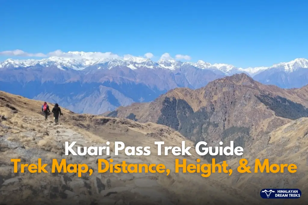
Are you looking for a Himalayan trek that gives you big mountain views without pushing your body to the extreme? The Kuari Pass Trek fits that space perfectly. It sits in the Garhwal Himalayas of Uttarakhand and offers long mountain walks, wide meadows, and close-up views of some of the tallest peaks in India.
Trekkers often call Kuari Pass the “Curzon Trail” because Lord Curzon once walked this route in the early 1900s. But history aside, the trek stands strong on its own merit. It balances distance, altitude, and terrain in a way that works for beginners and still excites experienced hikers.
This guide focuses on Kuari Pass trek distance, height, route map, difficulty and more. It also answers common questions like whether beginners can do it and how it compares with Kedarkantha. All details shared here rely on established trekking routes, verified altitude data, and commonly followed itineraries.
Kuari Pass Trek Location and Starting Point
Kuari Pass is located in the Chamoli district of Uttarakhand, inside the Garhwal Himalayan region. The trek begins from Dhak village, a small mountain settlement near Joshimath.
Dhak is the official Kuari Pass trek starting point for most standard itineraries. From here, the trail moves through Tugasi village, oak and rhododendron forests, alpine meadows, and finally reaches the high-altitude Kuari Pass.
Joshimath acts as the last major town before the trek. It has basic hotels, medical facilities, and the nearest ATM for Kuari Pass, which is why trekkers are advised to carry sufficient cash from Rishikesh itself.
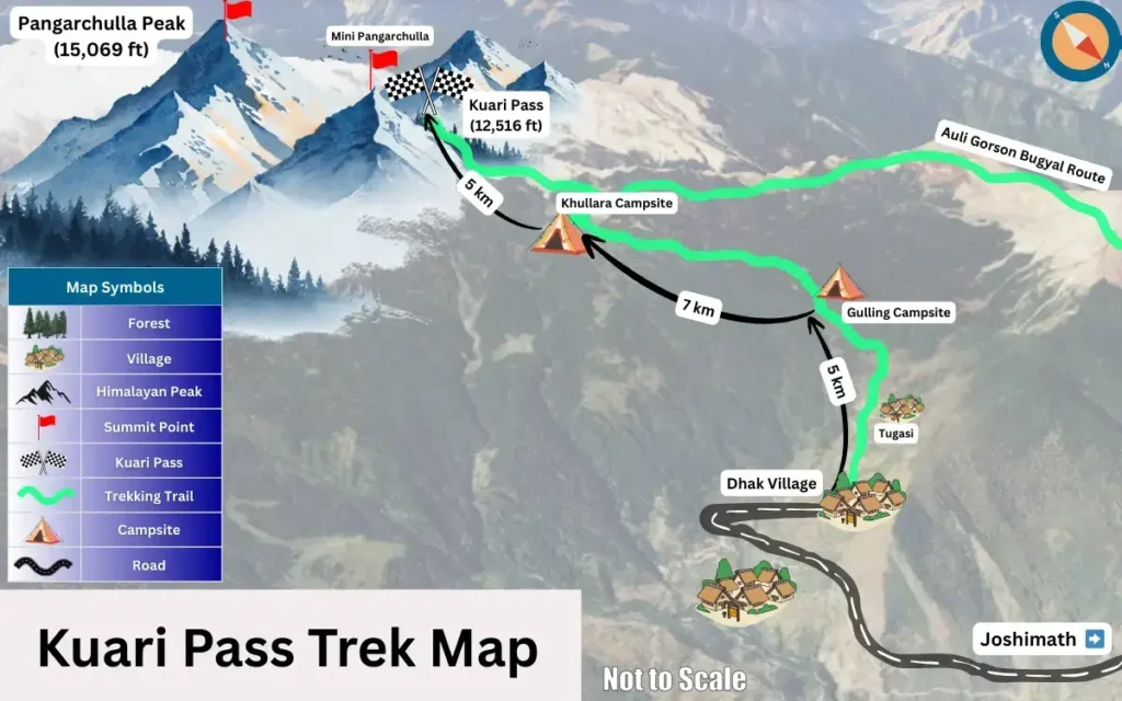
Kuari Pass Trek Map Explained Simply
The Kuari Pass trek map follows a clear and well-established circuit route. While routes may slightly vary based on campsites, the core trail remains the same.
Standard route flow:
Haridwar or Rishikesh → Srinagar → Devprayag → Karnprayag → Pipalkoti → Joshimath
Joshimath → Dhak Village → Tugasi → Gulling → Khullara → Kuari Pass → return via Khullara → Dhak → Joshimath → Rishikesh
This route keeps altitude gain gradual and helps trekkers adjust naturally.
Haridwar and Rishikesh to Kuari Pass Distance
Many trekkers ask about road distance before the trek even begins.
- Haridwar to Joshimath distance: approx. 270 km
- Rishikesh to Joshimath distance: approx. 255 km
From Joshimath, Dhak village lies about 12–14 km by road, and from there it is another 16–17 km up to Kuari Pass.
So when people ask about Haridwar or Rishikesh to Kuari Pass distance, it usually means the road journey up to Joshimath plus the trekking distance beyond Dhak.
Kuari Pass Trek Distance Guide
The trekking distance from Dhak village to Kuari Pass is around 16 to 17 km one side, depending on campsite placement. You can clearly see the campsite locations on the trek map mentioned above.
Daily walking usually ranges between 5 to 7 km, which keeps the pace manageable.
The Kuari Pass trek distance round trip comes to approximately 33 km. This includes:
- From Dhak to Gulling: 5 km
- From Gulling to Khullara: 7 km
- From Khullara to Kuari Pass: 5 km
This distance plays a major role in defining the trek’s difficulty. It challenges stamina but does not overload the body when done over multiple days.
Kuari Pass Height and it’s Highest Altitude
The Kuari Pass height is approximately 12,516 feet (3,815 meters) which is the highest altitude of the trek.
The altitude stays within a safe trekking range for most healthy individuals. The ascent remains gradual, which reduces the risk of altitude sickness.
Altitude Gain Pattern
- Dhak village starts at around 6,800 feet
- Gulling campsite sits close to 9,000 feet
- Khullara reaches about 11,000 feet
- Kuari Pass tops out at 12,516 feet
This step-wise gain helps beginners adapt without stress.
Terrain and Route Conditions
The Kuari Pass route passes through varied terrain:
- Stone-paved village trails near Dhak
- Dense oak and rhododendron forests
- Open alpine meadows like Gorson Bugyal
- Snowfields near the pass in winter
The trail remains wide and clearly defined. Sharp ridges or exposed cliff walks do not dominate this trek, which adds to its safety.
Kuari Pass Trek Duration
The Kuari Pass trek duration usually ranges between 5 to 6 days, including travel days from Rishikesh or Haridwar.
Most standard itineraries follow this pattern:
- Day 1: Rishikesh to Joshimath drive
- Day 2: Joshimath to Dhak and short trek to Gulling
- Day 3: Gulling to Khullara Campsite
- Day 4: Khullara to Kuari Pass and return
- Day 5: Khullara to Joshimath or Dhak
- Day 6: Joshimath to Rishikesh or Haridwar drive
The walking hours stay reasonable on trekking days, which helps maintain energy levels
Kuari Pass Weather and Temperature Overview
Kuari Pass Weather by Season
- Spring (March to April): Clear skies, snow patches near the pass
- Summer (May to June): Pleasant days, cool nights
- Monsoon (July to August): Slippery trails, limited views
- Autumn (September to November): Stable weather, sharp mountain views
- Winter (December to February): Heavy snow, colder conditions
Kuari Pass Temperature Range
- Daytime: 5°C to 15°C depending on season
- Nighttime: Can drop to -5°C in winter
Checking Kuari Pass temperature and weather before planning helps with clothing and safety decisions.
Kuari Pass Trek Difficulty Explained Clearly
The trek falls under the easy to moderate category.
Here is why:
- Distance: Daily walks stay under 7 km
- Height: Maximum altitude remains below 13,000 feet
- Terrain: Mostly gradual ascents with limited steep sections
Snow in winter increases effort, but guides manage pacing and safety.
So Can Beginners Do Kuari Pass Trek?
Yes, beginners can do Kuari Pass Trek if they have basic fitness. Regular walking, light cardio, and leg strength training before the trek help a lot.
Families and first-time trekkers complete this trek every season.
Why is Kuari Pass trek special?
Kuari Pass is special for providing a wide view of Himalayan ranges. It lies deep inside the Garhwal Himalayas and offers views of major Himalayan peaks such as-
- Mt. Nanda Devi (India’s second highest mountain)
- Kamet
- Chaukhamba
- Dronagiri
- Neelkanth
- Trishul
Such close and wide-ranging views are rare on many beginner-level treks.
Kuari Pass vs Kedarkantha: Which Is Better?
This question comes up often, and we have described it in detail in our post Kuari Pass vs Kedarkantha.
- Kedarkantha works well for first-time winter trekkers who want a short climb and summit experience.
- Kuari Pass offers longer walks, broader landscapes, and more Himalayan peak views.
If you want depth, distance, and classic Himalayan scenery, Kuari Pass feels more rewarding.
Final Thoughts
This guide on Kuari Pass trek map covers everything from travel or trek distance and height to weather, and difficulty. The trek stays accessible while still delivering serious mountain views.
The Kuari Pass trek distance challenges your stamina but never overwhelms you. The altitude stays safe, and the terrain remains friendly. Add forests, meadows, snowfields, and Nanda Devi standing tall in front of you, and the experience feels complete.
If you want a Himalayan trek that builds confidence and leaves lasting memories, Kuari Pass earns its place on your list.
Leave a Comment