Overview
The Benog Tibba trek is one of the most off-beat short treks in the Mussoorie Wildlife Sanctuary. Benog Tibba or Benog Hill summit is situated at an elevation of 7,431 ft with Jwala Devi Temple sitting atop, making it one of the highest peaks in the region. It is surrounded by the Yamuna Valley, and the Assan Barrage to the west, the Mussoorie hills to the east, Doon Valley to the south, and prominent Himalayan ranges to the north.
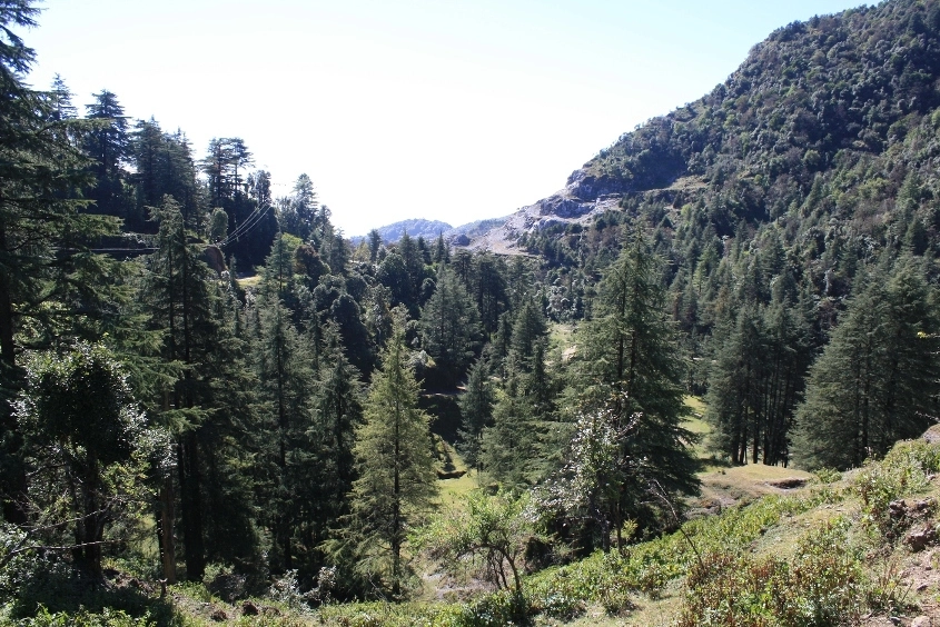
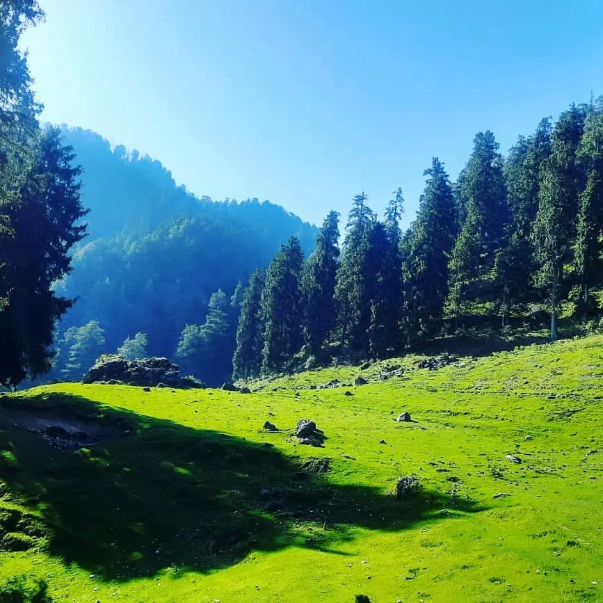
The trek starts from the Cloud End in Mussoorie, taking you through the dense pine and oak forest trails. Once you enter the Benog Wildlife Sanctuary, the beauty of the flora, accompanied by the melody of birds, mesmerises you with each step. The sanctuary was established to protect the Mountain Quail, a critically endangered bird. If you are lucky, you can spot others like the Red-billed Blue Magpie, Kalij Pheasant, and various woodpeckers.
This underrated short day hike is easy to attempt and is suitable for beginners and people with adequate physical fitness. It is perfect for photography lovers who want to capture the raw beauty of the Himalayan forest and the distant Garhwali peaks like Bandarpoonch, Swargarohini, and Srikantha, and even the Gangotri ranges.
The Benog Tibba trek is an all-season trek that entices people with its varied landscape in every weather. You can visit it during winter, spring, summer, and autumn to get the best camping experience. The entry is restricted during the monsoon season, as the trails become slippery, prone to leeches, and the weather gets unpredictable.
If you are looking for a weekend trek in Uttarakhand, the Benog Tibba trek is accessible from major cities like Dehradun, Delhi, and Chandigarh. Let us learn more about its day-wise itinerary, best time to visit, difficulty analysis, and how to reach Benog Tibba.
Itinerary
Drive Distance and Time: 37.6 km; 2-3 hr
Hike Distance and Time: 4 km; 2-3 hours (one way)
Altitude Gain: 640 m/ 2,100 ft at Dehradun to 2,264 m/ 7,431 ft at Benog Peak Summit
Today’s Difficulty: Easy to Moderate
Highlights: Dense forest trails, birdwatching, and visit Jwala Devi Temple.
The trails of the Benog Tibba Trek start from the Cloud End Forest, which is about 11 km from Mussoorie’s main town. To start your journey, first arrive at Dehradun early in the morning or on day 0. The drive will take you through the winding roads with scenic views.
On your way through Rajpur road, you will cross Jharipani and Bhatta Falls. Once you arrive at Hathipaon Chowk, you will see two routes cutting from here. The one to your side goes towards the George Everest, and the straight route will take you to the Cloud End. Try to arrive here before 9:00-10:00 am to ensure enough time for the summit and a safe descent.
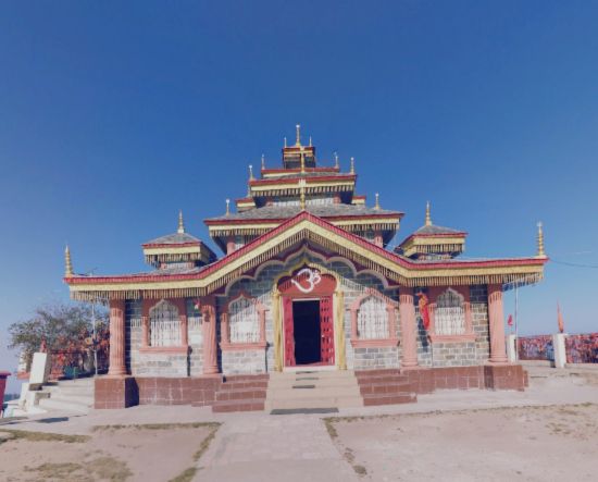
Upon arriving at the resort, you will see a board displaying the Jwala Devi Temple, indicating the entry point into the Mussoorie Wildlife Sanctuary. The trek starts from here with a gradual ascent through mixed forests, following trails used by locals. This well-preserved forest is home to several birds, including the Red-billed Blue Magpie, Himalayan Woodpecker, the rare Mountain Quail, and many more.
Once you are deeper into the woods, the narrow trails of the Pine forest, laden with dry leaves and wild flowers, will mesmerise you with their beauty. Further, you will arrive at the check post to enter the Benog Wildlife Sanctuary. Here, you can buy the entry ticket for about INR 200 per person for Indians and show your valid ID proof.
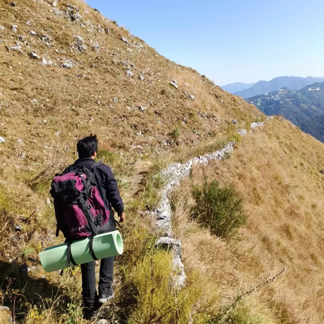
From here, the track steepens slightly, giving you the views of George Everest peak to the east and the distant Himalayan ridgelines. There are no shops or water sources inside this protected forest, so we advise you to carry ample food and water for the trek. After a few hundred meters of climbing, you will arrive at a forest clearing. Sit and relax here before continuing your journey further.
From here, the forest becomes less dense, and the ascent is gradual. On your way, you will see the scenic views of distant peaks dotted with small villages. You will finally see the Jwala Devi Temple sitting at the top of the Benog Hill. This final stretch is steep, where you will climb through the grassy slopes and Banjh Oak trees to reach the summit.
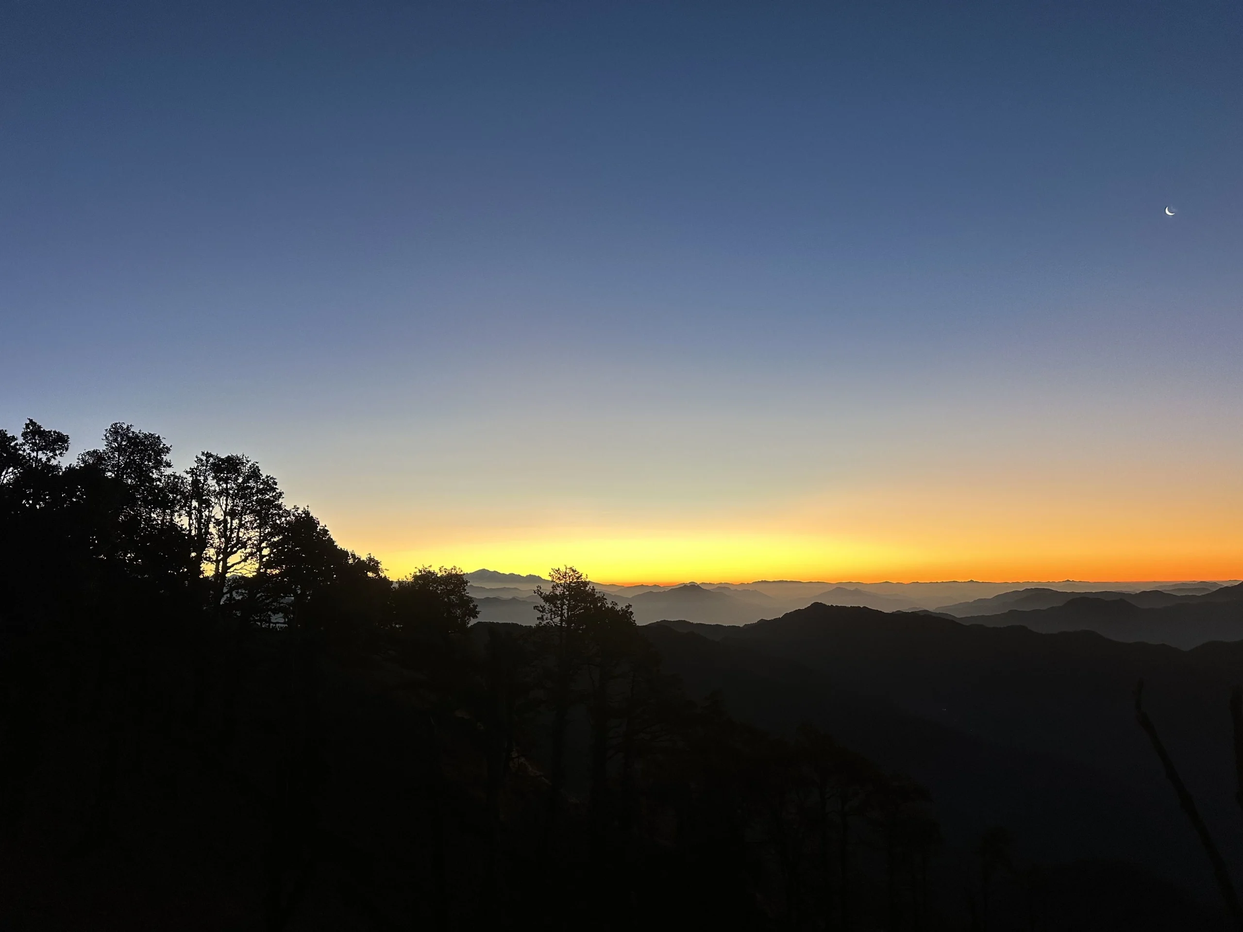
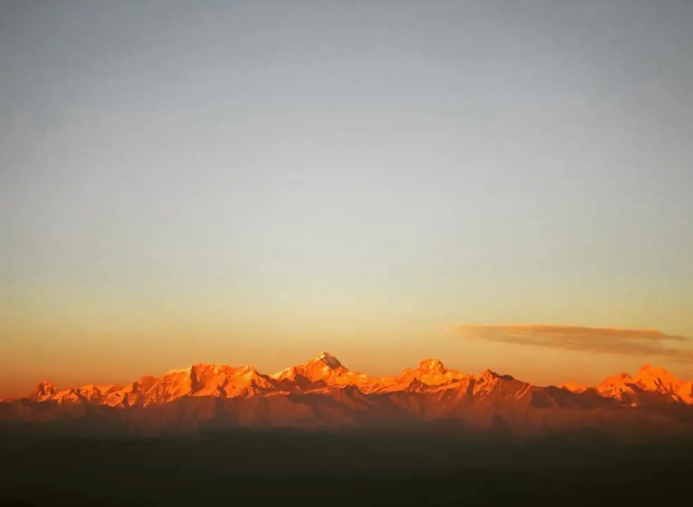
Pay your worship at the Jwala Devi Temple. Sit back and relax at the summit to catch the panoramic views of prominent Himalayan Peaks. On clear days, you can see Bandarpoonch, Swargarohini, and Srikantha peaks, along with the beautiful Yamuna Valley below. Spend some time here and have your packed lunch before continuing the descent.
For the night camp, you will descend towards the other side of the hill or have camp near the temple. Rest and relax here for an evening of camping, bonfire, and dinner.
Hike Distance and Time: 4 km; approx. 1.5 hour
Drive Distance and Time: 37.6 km; 2-3 hr
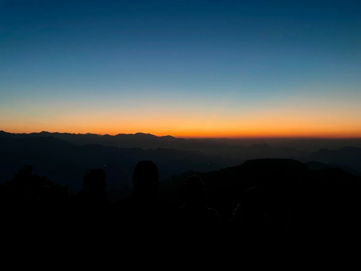
Wake up early in the morning to witness the ethereal sunrise in the mountains. Pack your belongings after having a simple breakfast. We will descend back to the Cloud End, where your vehicle will be waiting for the drive to Dehradun. Make sure you start the descent by 10:00 am, so you have time to explore Mussoorie or Dehradun, if possible.
The short nature walk on the forest trails lined with tall Oak and Pine trees will keep you enthusiastic. Soak in the crisp and clean air of the wilderness and the soft sunlight filtering through the tall canopies. Take pictures and keep your eyes peeled for the rare birds of the forest.
You will arrive in Dehradun in the afternoon. Here, you can stay overnight and explore this thriving city or plan your journey back in the evening.
Inclusion and Exclusion
Price Inclusion
Transport: Transport from Dehradun
Stay: Night stay in tent
Meal: Dinner, Breakfast, and Lunch
Forest Entry and Permits: All required fuel charges, tolls, forest entry fees, and permits are covered.
Guide: A qualified guide will accompany you.
Emergency Kit: First aid medical kits are provided for safety.
Price Exclusion
Emergency Evacuations: Any charges related to emergency evacuation are not included
Personal Expenses: Any meals or accommodations outside of the provided itinerary or additional services not listed in the inclusions.
5% GST
Check the booking procedure, including details on booking deposits, payment terms, and the cancellation policy.
Difficulty Level
Benog Tibba trek is an easy trek, suitable for beginners and trekkers of all ages, from children to seniors, with basic fitness. The forest trails in the wildlife sanctuary are natural and accessible, with a few rocky tracks. However, it can be narrow in some of the sections, where only one person can pass through at a time.
The Benog Tibba trek is often known as one of the introductory treks due to its short walking distances, about 5-6 km, and gradual ascent. It may pose some weather-related challenges depending on the season you are planning to do this trek. The altitude gain is approximately 800 ft from Mussoorie, which is manageable for everyone. Overall, this easy trek serves as the perfect entry point for new trekkers to get familiar with the terrains of the Himalayas.
Things to Carry
- Sleeping Bag
- Common Tent
- Mattress
- Dining Tent
- Camping Stool
- Walkie Talkie (For Team)
- Utensils
1. Clothing
- Outer Layer: 1 Down Jacket (Winter)
- Gloves: (Winter)
- Headwear: 1 Warm Hat + 1 Scarf/Balaclava (Winter)
- Sun Hat: 1 (Summer)
2. Footwear
- Hiking Shoe
3. Backpack & Trekking Gear
- Daypack: 1 (For day-hike)
- Trekking Poles/Sticks: 1 pair
6. Health & Hygiene
- Sun Protection: Sunscreen
- Lip Balm: 1
- Snacks: Energy bars, dry fruits, chocolates
7. Accessories
- Bottle/Bladder: 1
- Sunglasses: 1 (UV-protected and polarized)
How to reach Benog Hill?
Mussoorie serves as the base for the Benog Tibba Trek, and the actual trail starts from Cloud’s End.
- By Air: The nearest airport is Jolly Grant Airport (Dehradun), approximately 58.1 km away from Cloud End. From the airport, you can hire a private taxi to Mussoorie or take a UTC bus.
- By Rail: The Dehradun Railway Station (34.1 km away) is the closest railhead. It is well-connected to Delhi and other major cities.
- By Road: You can take a local bus or cab from Mussoorie’s Mall Road to Cloud’s End (approx. 7-8 km). Many trekkers prefer hiring a scooty or taxi for this short distance.
The nearest major railway stations are Haridwar and Rishikesh. From these stations, one can take a taxi or board a bus to Rudraprayag or Ukhimath. The road journey from Rishikesh to Chopta takes around 8 to 9 hours. Regular buses are available to Rudraprayag and limited services to Ukhimath. From Ukhimath, which is about 30 kilometers from Chopta, shared jeeps or private taxis can take you to the base.
If you’re planning to travel by car, it’s better to leave early in the morning and aim to reach Chopta by the afternoon. Ukhimath is the last town with ATM facilities and petrol pumps, so it’s a good place to stop and refuel or withdraw cash. Roads beyond Rudraprayag are narrow but manageable. It is wise to carry enough fuel, cash, and warm clothes.
From Rishikesh take a bus to Karanprayag and from there change buses for Tharali. Tharali is connected to Loahjung and local taxis are available. Alternatively, you can also reach Lohajung via Haldwani. From Haldwani, take a bus to Tharali and from Tharali take a taxi to Lohajung.
Best Time to Visit
Benog Tibba is accessible throughout the year except during the monsoon. Each season brings a unique beauty to the forest trails of this trek, from the golden landscape in autumn to the colourful wildflowers in spring. The best time for the Benog Tibba trek depends on your preference and the experience you are looking for.
Here is a detailed breakdown of what to expect during different seasons:
Winter
Months: November to February
Temperature: 23°C- 15°C during the day; 7°C- 2°C at night
Winter is the ideal season for adventure seekers who want to experience snow in Mussoorie and get clear views of the distant Garhwal Ranges. November and December bring cold and pleasant days and chilly nights, perfect for trekking in the forest. January and February often bring occasional snowfall to the Benog Tibba summit, where you might even encounter a light dusting of snow on the trail near the Jwala Devi Temple.
Spring
Months: March to April
Temperature: 26°C- 20°C during the day; 11°C- 8°C at night
March marks the retreat of winter, breathing life into the dormant forest with sprouting leaves and blooming wildflowers. This is one of the best times to explore the forest trails of the Benog Tibba trek as the weather becomes pleasant during the day. Spring is ideal for birdwatchers and photographers, as one can spot some of the rare and exotic species of the Mussoorie Wildlife Sanctuary.
Summer
Months: May to Mid-June
Temperature: 30°C- 25°C during the day; 17°C- 12°C at night
The Benog Tibba trek becomes an ideal destination for those who want to escape the heat in the plains and are travelling for summer vacation. This short weekend retreat provides longer daylight hours for trekking during this time of the year. The weather remains favourable with clear skies, and the dense Oak and Pine trees offer adequate shade for hiking.
Monsoon
Months: Late June to Mid-September
Temperature: 33°C- 24°C during the day; 18°C- 16°C at night
The region receives high rainfall during the monsoon, and hence, this season is not ideal for trekking. Avoid visiting the Mussoorie Wildlife Sanctuary during these months as the natural trails become infested with leeches and become very slippery for trekking. The forest floor gets covered with pine needles, making it risky for beginner trekkers.
Autumn
Months: Mid-September to October
Temperature: 25°C- 23°C during the day; 11°C- 7°C at night
Autumn offers one of the ideal seasons to visit the Bengog Tibba Trek. During this time, you will notice a picturesque landscape covered in ember hues, with red and yellow pine trees covering the canopy. This is the perfect time for photography enthusiasts and those who prefer the cold but favourable weather for trekking. The nights may become chilly in october so carry warm layers for protection.
The nearest major railway stations are Haridwar and Rishikesh. From these stations, one can take a taxi or board a bus to Rudraprayag or Ukhimath. The road journey from Rishikesh to Chopta takes around 8 to 9 hours. Regular buses are available to Rudraprayag and limited services to Ukhimath. From Ukhimath, which is about 30 kilometers from Chopta, shared jeeps or private taxis can take you to the base.
If you’re planning to travel by car, it’s better to leave early in the morning and aim to reach Chopta by the afternoon. Ukhimath is the last town with ATM facilities and petrol pumps, so it’s a good place to stop and refuel or withdraw cash. Roads beyond Rudraprayag are narrow but manageable. It is wise to carry enough fuel, cash, and warm clothes.
From Rishikesh take a bus to Karanprayag and from there change buses for Tharali. Tharali is connected to Loahjung and local taxis are available. Alternatively, you can also reach Lohajung via Haldwani. From Haldwani, take a bus to Tharali and from Tharali take a taxi to Lohajung.
Map and Weather
FAQs
Yes, it is a short and manageable trek with 7-8 km of hike both sides.
All year round except monsoon is good for Benog Tibba Trek.
Benog Tibba trek is considered easy day hike. It can be completed either in a day or two day with one night stay.
No, Benog Tibba Trek remains quiet and offbeat.


Leave a Comment