Overview
Pindari Glacier Trek is one of Kumaon’s classic Himalayan treks. It is perfect for trekkers who want a true glacier experience without technical mountaineering. The Pindari Glacier is situated southeast of Nanda Devi and Nanda Kot. It serves as the source of the Pindar River, which meets the Alakananda at Karnaprayag in the Garhwal district.
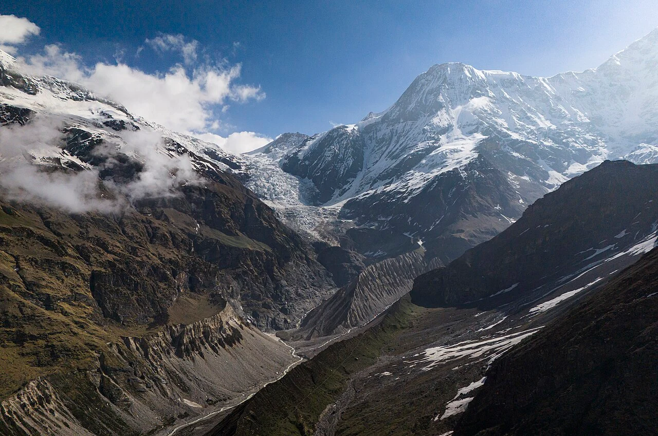
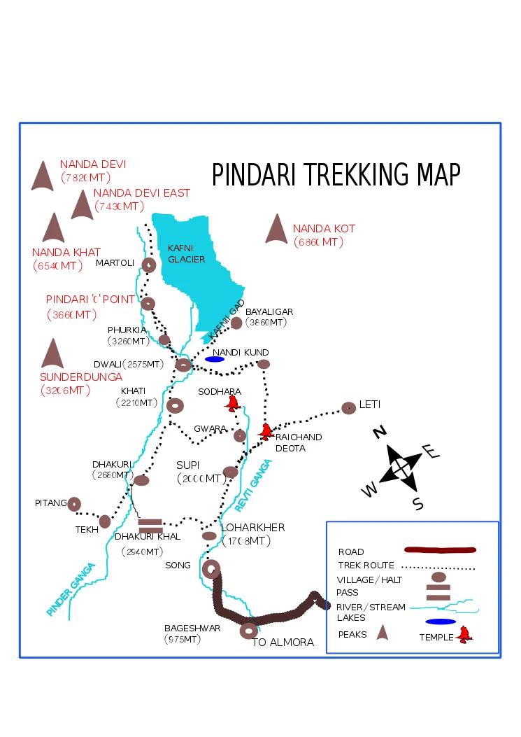
The Pindari Glacier trek starts from the Khati Village in the Bageshwar district. From there, its trails follow the Pindar River deep into the Nanda Devi Biosphere Reserve. It offers you a complete Himalayan experience of trekking through the dense forest trails, alpine meadows, Kumaoni settlements, moraine fields, and a high-altitude glacial valley. The trek ends at the Zero Point, which marks the point from where you get the closest view of the Pindari Glacier’s snout.
This trek is rated moderate and is ideal for experienced trekkers and beginners alike. The Pindari Glacier Trek takes six days to complete, where you will climb from 2,222 m in Khati to roughly 3,816 m at Pindari Glacier’s Zero Point. The total trekking distance is about 58-60 km, which will test your stamina and mental preparedness. The route is non-technical but involves multiple river and stream crossings and sections through landslide and moraine zones.
The best time to do the Pindari Glacier Trek is from mid-March to mid-June and from mid-September to late-October. These months offer you a peaceful escape into the mountains with favourable weather conditions for beginners. The trails of this trek remain inaccessible during the peak monsoon and winter seasons.
Planning for the Pindari Glacier Trek? Continue reading to get a detailed day-wise itinerary of the Pindari Glacier Trek, how to reach Khati Village, the best time to visit, and its difficulty analysis:
Trek Itinerary
Drive Distance and Time: 200 km; 6-7 hrs (From Kathgodam Railway Station to Kharkiya)
Trek Distance: 5 km; 1.5 hrs (From Kharkiya to Khati Village)
Altitude Gain: 535 m/1,754 ft (at Kathgodam) to 2,222 m/7,290 ft (at Khati)
Highlights: Witness the beauty of the Kumaon Himalayas via roads winding through popular hill stations of Uttarakhand.
The basecamp of the Pindari Glacier Trek is Khati Village in the Bageshwar district. On day 1, you will arrive at Kathgodam. Leave early in the morning as the driving time is around 6-7 hours, depending on the traffic and road conditions. Throughout the drive, you will witness the beauty of the Kumaon hills with roads running along the Kosi and Saryu rivers. The route via NH109 will take you through Bhimtal, Almora, Bageshwar, and Kapkot before reaching Khati.
After Bageshwar and Kapkot, the road becomes rough and bumpy as you head towards Bharari and further to Kharkiya. You will find a motorable road till Kharkiya, and from here you will trek to Khati, which is about 5 km from Kharkiya.
Khati is the last habitable village on this trek, which sits on the banks of the Pindar River. It serves as the base camp for multiple treks, including Pindari Glacier, Kafni Glacier, and Sunderdhunga. You will find many homestays and a KMVN guesthouse in the village to spend the night.
Note: The Last ATM point is at Kapkot, so withdraw sufficient cash
Trek Distance and Time: 13-14 km; 8-9 hrs
Altitude Gain: 2,222 m/7,290 ft (at Khati) to 2,612 m/8,570 ft (at Dwali)
Highlights: Trek through the forest trails that run parallel to the Pindar River.
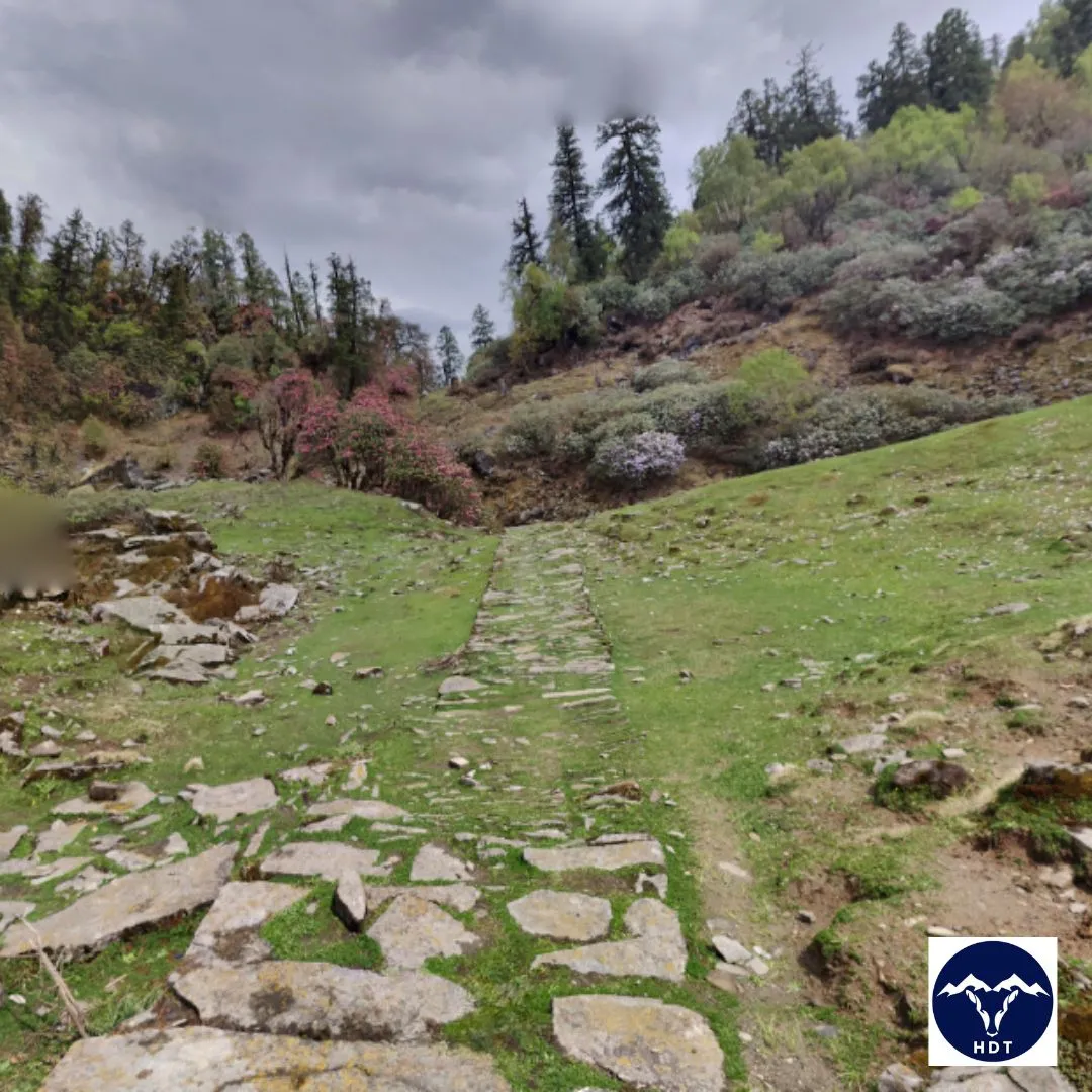
Day 2 marks the first day of trekking into the Pindari Valley. Fuel up with a hearty breakfast and set out towards the trail early in the morning. You will cover about 13 to 14 km today, but the gradient remains gentle throughout the trek. The trails start from Khati Village, and as you leave the colourful settlements behind, you enter a dense Himalayan vegetation.
The trails run along the beautiful Pindar River. Its gurgling sound and birds chirping will keep you company throughout the day. The first 2 km involve a gradual ascent and then a descent to cross the Pindar River via a suspension bridge. You will enter a dense forest of Ringal (a species of bamboo tree) and rhododendron shrubs. Keep your eyes peeled to spot the rare Himalayan flora blooming near the trails if you are trekking in spring.
Throughout the trail, you will find several sheds and benches set up by KMVN to relax. The path is usually well-marked, but some sections lie in landslide zones and may be rough and rocky. Cross these sections carefully and take the help of your trek guide to navigate them.
As you continue your trek, you will see the Pindar River flowing parallel to your right. You will also encounter a few small waterfalls and two small streams, namely Runiyat Nala and Jarthi Nala. After about 5 km from Khati, you will see a pitstop where you can take a break and have your refreshments.
The last stretch before Dwali involves a gradual ascent through dense forests. As you approach Dwali, the trees start to thin out. You will enter the area drained by the Pindar River, which is full of scree and moraine with very rough terrain. Before reaching, you will cross both the Pindar and the Kafni River via an unstable wooden bridge.
Dwali is a beautiful camping spot located near the confluence of the Pindar and Kafni rivers. Here, the trail splits where one trail leads to Pindari Glacier and the other to Kafni Glacier. You will camp near the river. After dinner, rest your feet, enjoy a hot meal, and prepare for tomorrow’s climb to Phurkia.
Distance and Time: 5 km; 3-4 hrs
Altitude Gain: 2,612 m/8,570 ft (at Dwali) to 3,240 m/10,632 ft (at Phurkiya)
Highlights: Steep climb through dense forests and views of Nanda Khat and Nanda Devi East
Today’s trekking distance may seem shorter and easier, but it involves steeper and challenging trail sections. After breakfast, start your trek to Phurkia. Climb through thick forests of rhododendron, birch, and oak trees. The path is well-marked but narrower than yesterday, and you may see uplifted tree roots that create natural pathways.
The complete route functions as a transition zone where the scenery changes gradually. As you ascend further, you will find that the closed valley opens up, giving you clearer views of your surroundings. Within the first hour, you’ll cross two frozen streams, ice bridges, or water streams, depending on the season. These crossings involve walking over rocks or small wooden logs, so take your time and use trekking poles if you have them.
After about 2.5 km, you will cross a high waterfall, reaching a small clearing where you can catch your breath. This is a small meadow, known as Jwarpani, which is also the highest point of today’s trek. Catch the beautiful views of vast grasslands and flocks of sheep grazing on them. If you are lucky, you may even spot Himalayan Tahr or Ibex climbing the higher altitudes of the surrounding hills.
The final approach to Phurkia is through a relatively easier gradient. The campsite sits in a beautiful meadow surrounded by towering peaks. On clear days, you can see Nanda Khat, Nanda Devi East, and others right from your tent.
Use the afternoon to rest, hydrate, and prepare for tomorrow’s summit day. Today’s trek is short so that you can acclimatize properly.
Trek Distance and Time: 16 km; 7-8 hrs
Altitude Gain: 3,240 m/10,632 ft (at Phurkiya) to 3,816m/12,520 ft (at Zero Point)
Highlights: Multiple stream crossings, moraine walking, and the views of Nanda Kot, Nanda Devi, Changuch Peak, Mt. Bauljuri
The fourth day of the trek marks the D-day, where you will finally witness the amphitheater of Pindar Glacier. Start early, at around sunrise, to use the daylight hours and avoid unpredictable rain. The trail starts with an uphill climb, and within 15 minutes, you will cross the first stream. During early spring or winter, you may find the streams frozen on your way, converted into ice bridges.
For the next 2 km, continue your ascent through rocky terrain with patches of snow (if spring). Gradually, you will enter a barren landscape in the inner realm of the Pindar Valley. The vegetation gets thinner, and you can finally catch glimpses of Nanda Khati and Panwali Dwar Peaks.
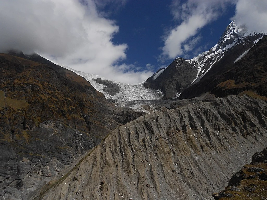
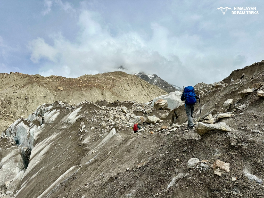
After about 2 hours of climbing, you will reach a vast field of moraine. Cross this section carefully, follow your guide, and watch your step. The Pindar River will keep you company throughout the route, flowing 50-60 m below. You will also see several big and small waterfalls draining into the river.
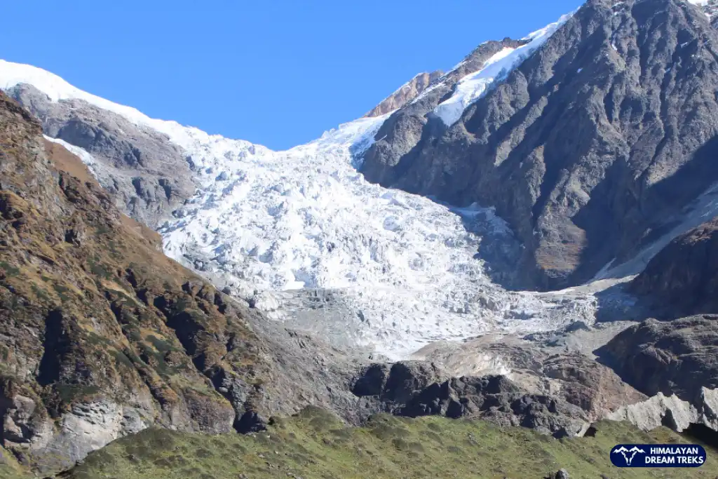
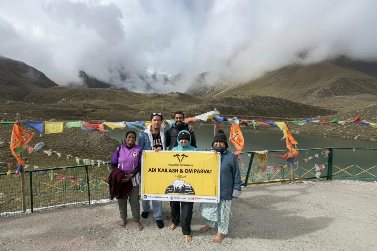
Eventually, you will enter the amphitheater (2 km before the zero point), spread across the beautiful meadow of Martoli. Some trekkers set up their camps here for the night if they do not plan to trek back to Phurkiya on the same day. Here, about 1 km before the zero point, you may find a small hut used by Baba Dharmanand (famous as Pindari Baba) and a small Nanda Devi Temple.
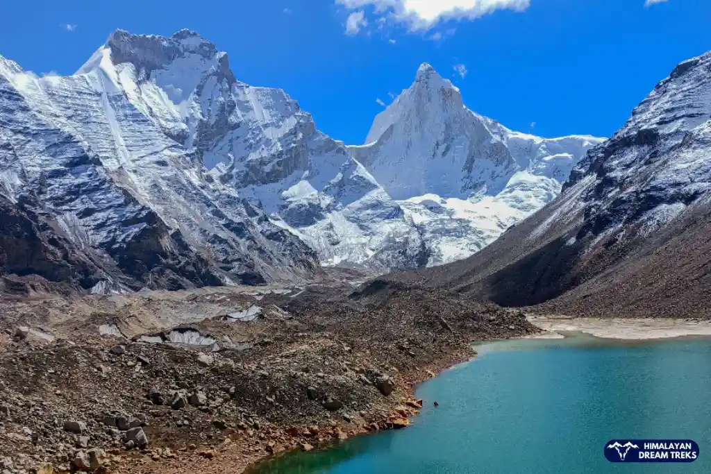
If the sky is clear, you will see the towering peaks like Nanda Kot, Mt. Bauljuri, and the Nanda Khat. As you approach Zero Point, the final stretch involves walking over glacial deposits and sometimes snow patches. At the highest point, you will stand at the edge of the Pindari Glacier, with Mt. Changuch standing tall towards your right.
The zero point marks the point from where the snout of the glacier is visible. Spend about 30-45 minutes here, take photos, sit quietly, and absorb the energy of the mountains. However, avoid staying for too long as the return journey is equally demanding.
Retrace your steps back through the same route. Descending on the moraine field requires careful footing, as loose stones may topple and make you slip. You will get back to your camp by late afternoon or early evening. Retire for the night and rest well.
Trek Distance and Time: 18 km; 10-12 hrs
Altitude Loss: 3,240 m/10,632 ft ( at Phurkiya) to 2,222 m/7,290 ft (at Khati)
Highlights: Return to civilization at Khati village
On Day 5, we will head back to the base camp of the trek. You will trek for the longest distance, losing about 1,000 m of altitude within a single day. Start early after breakfast to complete the trek before evening.
The first section from Phurkia to Dwali retraces the route you took on Day 3. Descending is much faster and easier on your lungs, but it can be tough on your knees. You can use trekking poles or a Ringal stick to reduce strain on your knees.
You will reach Dwali in about 2 hrs. Take a short break at Dwali, hydrate, and have some snacks. From here, the trail to Khati is the same one you covered on Day 2. It involves a gradual descent alongside the Pindar River.
The 11-13 km from Dwali to Khati may feel longer because your legs are already tired from the previous day’s zero-point push. Cross the landslide zones again carefully, and going downhill makes it easier to tread on. The walk through the forest is pleasant, and knowing that hot food and rest await you in Khati keeps spirits high.
As you approach Khati, the sights of the village with its traditional wooden houses and small shops will feel welcoming. Once you reach Khati, explore the village. You can also interact with locals or relax at the homestay.
Drive Distance and Time: 200 km; 6-7 hrs
Altitude Loss: 2,222 m/7,290 ft (at Khati) to 535 m/1,754 ft (at Kathgodam)
After an early breakfast, you will depart from Khati village for the long drive back to Kathgodam. The route retraces your Day 1 journey. You will have plenty of time to enjoy the drive, crossing by Himalayan peaks, meandering roads, and rivers. Many groups stop at Bageshwar town for a meal and to stretch their legs. You can also visit the local temples if time permits.
The drive from Bageshwar to Almora offers beautiful views of the valley. After Almora, the roads improve as you descend toward the plains. You will reach Kathgodam by evening, depending on road conditions and traffic.
Package Details
Price Inclusion
Accommodation for 6 nights: Stay is included from Day 1 to Day 5 (base camp to base camp). Single and double-sharing options are available at an additional cost.
Meals: Meals from Day 1 dinner to Day 6 breakfast.
Trek Equipment: All essential trek equipment is included, such as sleeping bags, kitchen and dining tents, utensils, mattresses, personal tents, toilet tents, and crampons (if needed).
Forest Entry and Permits: All required fuel charges, tolls, forest entry fees, and permits are covered.
Experienced and Certified Guides: A qualified, professional team, including a mountaineering-certified trek leader, guide, cook, and support staff, will accompany you.
Emergency Kit: First aid medical kits, oxygen cylinders, and stretchers are provided to ensure the safety, comfort and well-being of all participants.
Trek Certificate & HDT Badges: Receive a trek certificate and HDT badges to celebrate your adventure.
Price Exclusion
Meals during Transfer: Meals are not included while traveling to and from the trek starting points.
Emergency Evacuations: Any charges related to emergency evacuation are not included.
GST (5%): Not included in the package cost.
Personal Expenses: Any meals or accommodations outside of the provided itinerary or additional services not listed in the inclusions.
Personal Luggage Carrying: Charges for mules or porters to carry personal luggage are NOT included in fees.
Transportation from Kathgodam: Transport from Kathgodam is available at INR 3,000.
Best Time to Visit for this Trek
The trails of the Pindari Glacier trek are accessible during the summer and autumn seasons. These months offer favourable trekking conditions for most people. However, each season brings unique challenges and beauty to the Kumaon’s landscape.
Spring and Summer (Mid-March to Mid-June)
| Attribute | Detail |
| Temperature | Max: 4°C to 20°CMin: -10°C to 4°C |
| Weather | Warm days and clear skies at night |
| Landscape | Green meadows, dense forests, and blooming Rhododendrons |
| Best For | First-timers and those who want pleasant weather. |
The summer and spring seasons in the Pindar Valley mark the end of cold and chilly weather. During mid-March to April, you will see Rhododendrons, Primulas, and other wildflowers in full bloom. The entire forest is filled with greenery, with tall canopies of the oak and birch trees. The weather is usually calm during this time, but you may face unpredictable rain in the evening.
By this time, most of the snow on the lower trails melts, making walking easier. However, you may find ice bridges at the upper reaches of the Pindar Valley. From May to mid-June, the days get warmer, making the weather comfortable for trekking. You can choose this travel window if you want to do this trek with family or friends.
Autumn (Mid-September to Late October)
| Attribute | Details |
| Temperature | Max: 9°C to 18°CMin: -10°C to 5°C |
| Weather | Cooler days and chilly nights |
| Landscape | Golden landscape, meadows with dried grass, and post-monsoon greenery |
| Best For | Photography and crystal-clear mountain views |
If you are an experienced trekker and a photography lover, Autumn is one of the best time to do the Pindari Glacier trek. The post-monsoon air in mid-September is crisp and free of haze. You get the sharpest views of peaks like Nanda Kot and Nanda Devi East. The landscapes turn golden brown and the hills reflecting orange and pink sunset, adds to its beauty.
During October, the trekking conditions remain favourable with colder weather as you ascend to the upper reaches. However, nights start getting colder, often dropping below zero.
Note: Avoid July and August (Monsoon) due to heavy rainfall, leeches, and increased risk of landslides. Winter is generally closed or very difficult due to heavy snow blocking the trail beyond Dwali.
Difficulty Level of this Trek
The Pindari Glacier Trek is rated as a moderate-level trek in India, as it has accessible and well-maintained trail sections. If you are a beginner who wants to experience high-altitude trekking, this trek offers you the best opportunity to seek Himalayan adventure. You reach the glacier’s nearest spot (Zero Point) without crossing any difficult high passes or needing technical climbing gear. The main challenge is endurance. The daily walking distances are moderate (5-7 hours), but you need good stamina to handle the ascents and the rocky terrain.
Terrain
You will experience a variety of terrain on this trek, from easy sections to challenging ones. The trek starts through dense forests of oak and rhododendron, walking alongside the roaring Pindar River. You will also cross old landslide zones and frozen streams. The trail here can be narrow and rocky. As you climb higher, the trees disappear, replaced by grassy alpine meadows (Bugyals) and shrubbery. The final push involves walking over loose rocks, boulders, and glacial debris (moraine).
Altitude Gain
The itinerary of the Pindari Glacier trek ensures that the ascent remains gradual each day. This helps with acclimatization and reduces the risk of Acute Mountain Sickness (AMS). Each day you will gain between 1,000 to 2,000 ft, which is why it is important to maintain a consistent pace throughout the trails.
Walking Distance
The total walking distance of the Pindari Glacier Trek is about 58 to 60 km round trip from Khati. You will walk about 11-13 km on long days (Khati-Dwali) and 5-7 km on shorter but steeper days (Dwali-Phurkia). The summit day, which is Phurkia to Zero Point and back, involves about 14 km of trekking.
Trek Essentials
- 45-60 Ltr Bag Pack With Rain Cover & Comfortable Straps
- Hot and Cold Water Bottle Like Borosil and Milton
- Energy Bar, Dry Fruits, and ORS
- Personal Medical Kit
- 1 Pair of Sunglasses (UV Protected)
- 1 Neck Gaiters (Buff)
- Tiffin Box
- 2/3 Full Sleeves (Non-Cotton)
- 1 Full Fleece T-Shirt
- 1 Fleece Jacket (Woolen or Sweater)
- 1 Down Feather/ Hollofil Jacket
- 1 Waterproof Jacket/ Poncho
- 1 Pair of Thermal Inners (Upper and Lower)
- 2 Trek Pants (Avoid Shorts and Denim Pants)
- 1 Pair of Waterproof Gloves
- 1 Pair of Woolen Gloves
- Sun Cap
- Woolen Cap
- 4 Pairs of Cotton Socks
- 1 Pair of Woollen Socks
- 1 Waterproof and High Ankle Trekking Shoes
- 1 Pair of Floaters
- Hand Sanitizer and Sunscreen Lotion
- Toothbrush and Toothpaste
- Toilet Paper
- Quick Dry Towel
- Lip Balm and Antibacterial Powder
- Moisturizer
- Sleeping Bag
- Common Tent
- Mattress
- Dining Tent
- Camping Stool
- Walkie Talkie (For Team)
- Utensils
How To Reach Base Camp
The nearest airport is Pantnagar Airport, which is about 34 km from Kathgodam and 188 km from Bageshwar. There are direct flights from Delhi (Indira Gandhi International Airport) to Pantnagar.
From Pantnagar, you can hire a taxi to reach Kathgodam. From Kathgodam, you will need to hire a private taxi to reach Khati. You can also take a shared jeep to drive further to Bageshwar and then to Khati.
The most popular way to reach is via Kathgodam Railway Station (KGM). If you are planning to travel from Delhi, these trains are preferable:
- Ranikhet Express (15013): Leaves Jaisalmer/Delhi at night and reaches Kathgodam early morning (around 5:05 AM).
- New Delhi – Kathgodam Shatabdi (12040): A day train reaching Kathgodam by 11:40 AM.
- Uttar Sampark Kranti (15035): Another good option, if you want to arrive at Kathgodam on Day 0.
Once you arrive at Kathgodam, you can find taxis and shared jeeps at the station exit to take you toward Bageshwar.
The drive from Kathgodam to the road head near Khati is long and rough. It is connected via NH 109 and covers about 210 km and taking 9-10 hours.
Route: Kathgodam → Almora → Bageshwar → Kapkot → Bharari → Kharkiya → Khati
You can hire a private Bolero or Sumo from Kathgodam directly to Kharkiya or Khati. Alternatively, you can take a shared jeep or bus from Kathgodam/Haldwani to Bageshwar. From the Bageshwar taxi stand, take another shared jeep to Bharari Market/Saung/Kharkiya.Tip: The road from Saung to Kharkiya can be rough as it is currently under construction. Most trekkers drive till Kharkiya and hike the short 3-4 km trail to Khati village to warm up for the trek.
Get a bus from Haldwani, Kathgodam, or Nainital for Bageshwar. From Bageshwar, take a shared taxi to Khati village.
Trek Map
Weather & Temperature
Nearby Places to Visit
Near the basecamp of Pindari Glacier Trek, which is Khati Village, you can also explore these beautiful destinations:
- Dhakuri Village
- Takuli Chilta or Chilta Top
- Pongu Top
- Loharkhet
- Kafni Glacier Trek
- Bageshwar
- Sunderdhunga Trek
SCL, Foreign National Charges & Vehicle
Himalayan Dream Treks (HDT) is registered tour operator with the IMF, and we can cater to the needs of SCL for Government Employees. According to the rule, the government of India provides its employees with a prospect where they’re allowed to apply for a 30-day special casual leave in a calendar year to do trekking, hiking, or whatever adventure pleases them.
Mail us at info@himalayandreamtreks.in, if you want to avail SCL.
For foreign nationals, permit charges are different, and hence the overall package price is different for foreign trekkers. Connect with us before booking your trek. For more details, contact us at info@himalayandreamtreks.in
- For 4-6 people Bolero or equivalent vehicle.
- For 7 or more people, Force Traveller.


Leave a Comment