Overview
The Ranthan Kharak Trek is a hidden gem in the Kumaon Himalayas of Uttarakhand. It is situated in the remote valleys around the Namik region of Bageshwar district. It climbs to an altitude of around 13,000-13,300 feet (4,000 m) at Ranthan Top. The complete trek covers approximately 35 to 40 km over 7 days. This makes it a rewarding high-altitude trek. Throughout the route, you witness the views of the Kumaon and Garhwal ranges. These include Nanda Devi, Nanda Kot, Panchachuli, Trishul, and Maiktoli, which dominate the horizon.
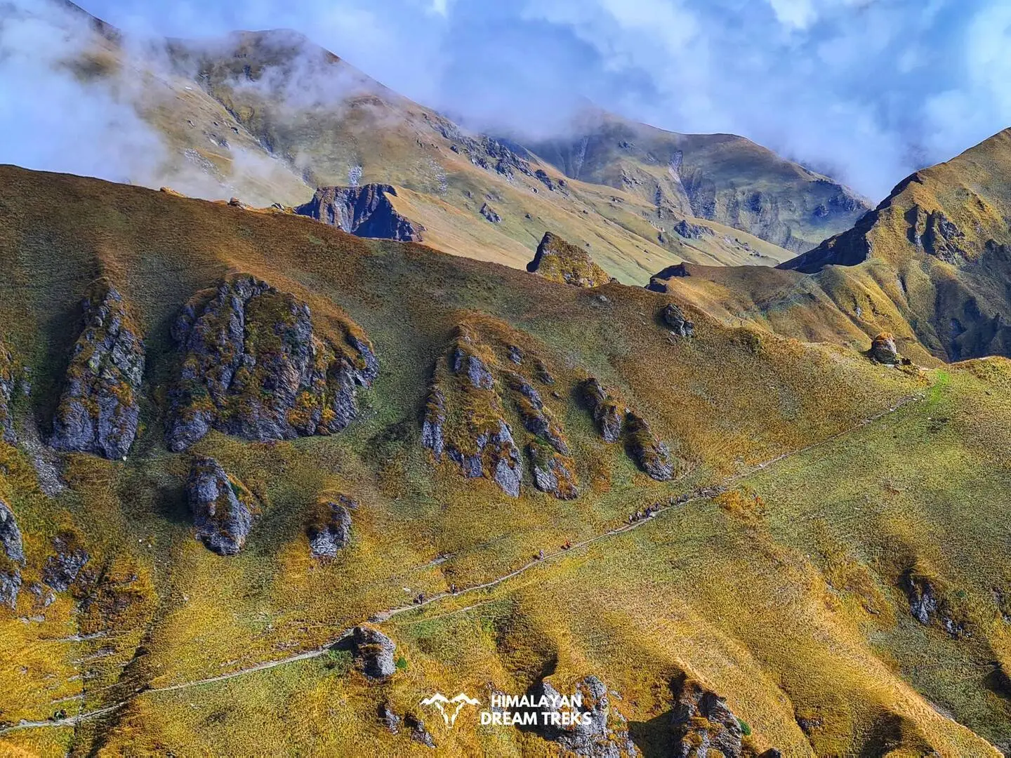
The Ranthan Kharak trek starts from Gogina village, a Kumaoni settlement that serves as the base camp. From here, the trail winds through terraced fields, oak, and rhododendron forests. The main highlights are its high-altitude “kharaks” (meadows) such as Namik, Bajimanian Kharak, and Thal Tok, before you climb a ridge to Ranthan Top. Along the way, you walk above the Ramganga valley, pass near the Namik Glacier region, and camp in wide alpine clearings. These give you sunrise-to-sunset views of snow-capped peaks. This makes the Ranthan Kharak Trek one of the most scenic and rewarding treks in Uttarakhand.
The overall difficulty of the Ranthan Kharak trek is easy to moderate. This makes it suitable for fit beginners as well as experienced trekkers who want a solitary but adventurous Himalayan trail. There are water sources at intervals on the route, and the gradual height gain through Namik and Bajimanian Kharak helps with acclimatisation.
The best time to visit the Ranthan Kharak trek is during spring (April-June) and autumn (September-November). During these windows, the trails are stable, and the mountain views are at their finest.
Ready to take on this Himalayan adventure? Scroll down to get a detailed day-wise itinerary, how to reach the basecamp, difficulty analysis, and the best time to plan the Ranthan Kharak Trek, and prepare for an unforgettable experience of trekking in Uttarakhand.
Trek Itinerary
Drive Distance & Time: 233 km; 8-10 hours
Altitude Gain: 1,752 ft/534 m (At Kathgodam) to 6,391 ft/ 1,947 m (At Gogina)
Highlights: Scenic drive through the popular hill stations of the Kumaon region
On day 1, you will arrive at Kathgodam to begin your journey towards the basecamp of the Ranthan Kharak Trek, which is Gogina Village. The 8 to 10-hour drive passes through the scenic routes along the NH109 in Uttarakhand. You will cross several popular locations like Nainital, Almora, Bageshwar, and Kapkot.
Keep your eyes peeled for the beautiful views of the Garhwal foothills in the distance. The tall pine forests and their dense canopies lining the mountain roads make the drive mesmerising. You will pass through several remote Kumaoni Villages like Sama and Liti, and their terraced fields along the mountainsides.In the evening, if the road conditions are good, you will arrive at your homestay in GoginaVillage.
This is one of the last inhabited villages in the Bageshwar district. By now, you have gained about 1,400 m of altitude, so spend a night here to acclimatise and rest. If time permits and energy allows, visit the nearby Lord Shiva temple.
Trek Distance and Time: 6-7 km; 6-7 hours
Altitude Gain: 6,391 ft/ 1,947 m (At Gogina) to 7,021 ft/ 2,140 m (at Namik)
Highlights: Cross the Ramganga River and climb through the dense forest trails.
Wake up early and enjoy the warm breakfast at your homestay in Gogina. You will start today’s trek by taking the trail that passes from the terraced agricultural fields, leaving the village settlement behind. Initially, the descent is steep, so stay mindful of your footing.
As you descend, the landscape changes, giving way to denser forest trails. In the early morning, you can spot many bird species as their chirps fill the surroundings. After climbing for about 2 km, take a short break at a small clearing. Then, after hiking for 1 km, you will arrive at a small stream with a suspension bridge crossing. This is the Ramganga River, which originates from the Namik Glacier high in the mountains. The bridge is located at the border of Uttarakhand’s two important districts, Bageshwar and Pithoragarh.
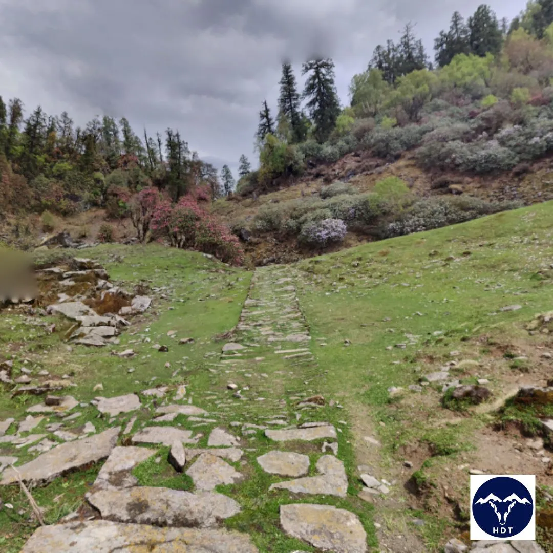
Once across the bridge, you enter a broad-leaved oak forest. This section of the trail is well-maintained, lined with paved stone steps. You are now climbing on the remnants of the ancient Indo-Tibetan trade route that once connected India to Tibet. Continuing upwards, for about the next 3 km, you will finally enter the Namik Village.
Namik village is the last village of Pithoragarh, which also serves as the base camp for other treks like the Namik Glacier trek. There is a small Nanda Devi Temple in the village and a small stream where you can fill your water bottles. Your trek guide will find a suitable clearing to set up the tents for the night. Sleep early after dinner to stay prepared for the next day.
Trek Distance & Time: 5.4 km; 6-7 hours
Altitude Gain: 7,021 ft/ 2,140 m (at Namik) to 9,622 ft/2933 m (at Bajimanian Kharak)
Highlights: Witness the beauty of several alpine meadows or Kharaks amidst the beautiful trails of Rhododendron forests.
Wake up early to the beautiful views of the Namik Village and its local life. After breakfast, begin by ascending the trail that follows a grassland with several chhanis and grazing animals, before getting into the deep forest. If you are trekking during April, the pink, red, purple, and white flowers of Rhododendrons make the green forest even more beautiful.
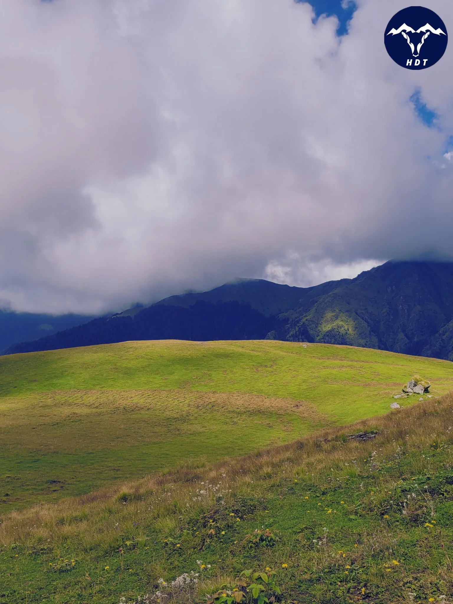
After climbing for 3 km, you will arrive near a small stream. Further, the next 500 m on the trail will take you to a big alpine meadow. This is Raj Kharak, where you can rest and catch your breath. The next pit stop is Purva Thaur, another big grassland.
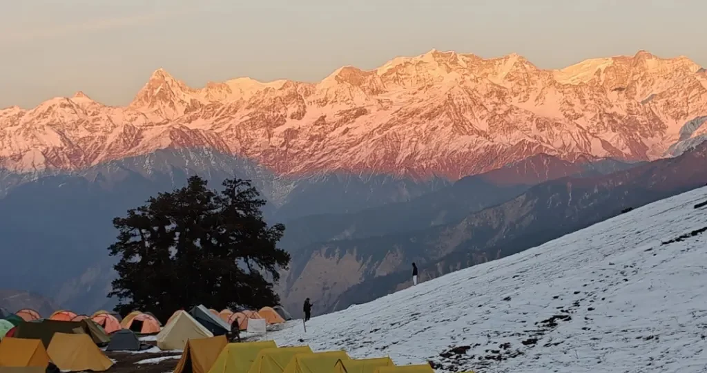
By late afternoon, you arrive at Bajimanian Kharak, a beautiful high-altitude meadow camping site. This clearing is surrounded by rocky slopes on its sides, making it a stunning camping site. The meadow itself is soft and inviting, perfect for camping. Set up your tents here, prepare a warm meal, and spend your evening enjoying the sunset at the Kharak.
Trek Distance & Time: 5 km; 6-7 hours
Altitude Gain: 9,622 ft/2933 m (at Bajimanian Kharak) to 11,108 ft/ 3,386 m (at Thal tok)
Highlights: Trek through dense forests and the expansive Kharaks via a steep and challenging climb to reach Thal Tok.
Today, you will cross some of the challenging sections of the Ranthan Kharak Trek. Start early in the morning by ascending through the alpine grassland. The terrain is gentle with patches of vegetation and rocky sections. However, the entire trail is well-marked and accessible, which is easy to navigate. Gradually, the meadows disappear, and the rocky hill sections appear, with the trail following the natural contours of the mountain.
As you continue climbing, the terrain opens, and you see a moorland-like section with short grass and low vegetation. Further, you will reach a small meadow known as Sur Sungri (named after the wild boars or ‘suar’). This region works like a crossroads, with trails splitting into four directions. The four different routes lead to Ranthan Kharak and Namik Glacier, Birthi waterfall and Munsyari, Baji Kharak campsite, and a remote village.
Continue your climb towards the Namik glacier route, through the Rhododendron forest. After 2-3 km, you will arrive at another alpine meadow, called Thala Gwar Kharak. Take a break here and have refreshments. The last 40-50 minutes towards the Thal Tok is a very steep and challenging climb. The trail is well-marked, but consists of large boulders and loose rocks.
Near Thal Tok, you reach a distinct ridge line. From this point, the landscape opens, and on clear days, you can see the first distant glimpses of the major Himalayan peaks. Thal Tok is both a campsite and a ridge area. Set up your camp here, and spend your evening acclimatising to the altitude and recovering from the day’s exertion.
Trek Distance & Time: 14-15 km; 11-12 hours
Altitude Gain: 11,108 ft/ 3,386 m (at Thal tok) to 13,334 ft/ 4,064 m at Summit
Altitude Loss: 13,334 ft/ 4,064 m to 7,021 ft/ 2,140 m (at Namik)
Highlights: Make a successful summit and witness the surrounding Garhwal and Kumaon Himalayan Ranges.
Finally, on the fifth day, you will climb to the summit. This is the longest, most challenging, and most rewarding day of this trek. Start early in the dawn, around 4:00-4:30 pm, so that you can catch the beautiful views at sunrise, and head back to Namik early.
The trek starts with a steep climb through the well-marked but rocky terrain. You will cross the rough moraine and bouldery sections of the trail. Continuing further, you will arrive at the Chophu Top, a flat mountain ridge. Take a short break here before you climb further towards the uphill trail. Carefully cross the rough sections on the hill and be mindful of your footing. If you are travelling during the spring season, you will see grass and ice as you approach the higher altitude.
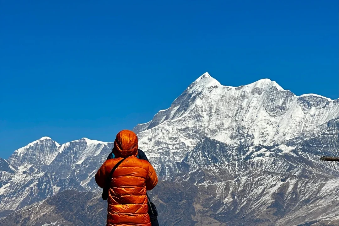
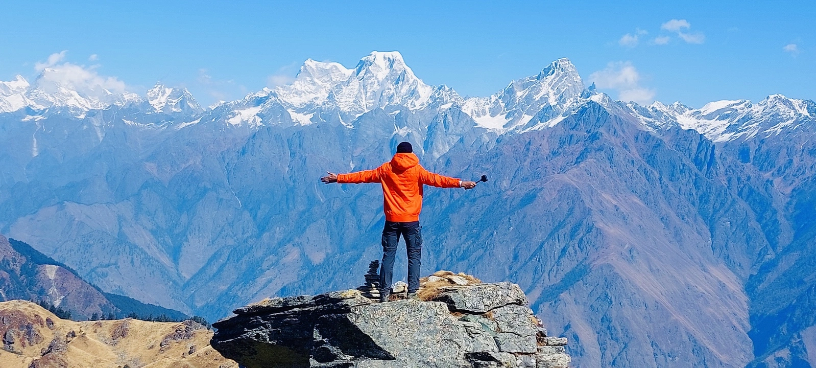
Finally, you will arrive at Ranthan Top, a flat area with cairn rocks and flags, also the summit point of Ranthan Kharak. Here, you will get the spectacular views of the prominent peaks of the Kumaon and Garhwal Himalayas. On one side, you will see Dang Thyal, Nanda Kot, Nanda Devi East, and Nanda Devi peaks. Towards the east, the five peaks of the Panchachuli range, and Panwali Dwar, Rajrambha, Trisul, and Meneka stand tall.
Soak in the majestic views and take pictures. Once you have celebrated the summit, prepare for a long descent back to Namik village. Retrace your steps down to Thal Tok to reach your previous day’s campsite for a lunch break. Then, continue your journey downwards to cross the Bajimanian Kharak route.
This long descent may feel daunting and cause fatigue in your knees. You will lose about 6,000 ft from the summit as you approach Namik. However, entering the lush meadows and dense forests reduces your tiredness. Remember to take appropriate pit stops and breaks to give your lungs and legs some rest.
You will arrive at the Namik Campsite by late afternoon or early evening. Relax and retire for the night and reminisce about your successful summit.
Trek Distance and Time: 6-7 km; 6-7 hours
Altitude Loss: 7,021 ft/ 2,140 m (at Namik) to 6,391 ft/ 1,947 m (At Gogina)
Wake up early to witness the beautiful sunrise over the valley one last time. Today, we will descend back to Gogina by retracing the trails to Gogina. It starts with a sharp descent through a dense forest. Place your foot carefully over the stone-paved sections, as they can be slippery on a downhill track.
Once you cross the Ramganga river, get on the other side of the trail via the suspension bridge. Relax by the bank of the river and soak in its beauty. Then, continue your descent further for the next 3 km. The gradient will descend gradually, and it will be easier to cross the final section. You will pass through the familiar terraced fields and slate-roofed houses. Upon reaching Gogina, settle back into your homestay.
Drive Distance and Time: 233 km; 8-10 hours
The seventh day marks the end of your Ranthan Kharak Trek. We will leave Gogina early after having a warm local breakfast. The long drive will take you through the beautiful Ramganga Valley. Admire the stunning views of the ridges and peaks on your way.
The drive will pass through the towns of Sama and Kapkot before reaching Bageshwar. We will stop for lunch/refreshments at Bageshwar, where you can see the confluence of the Sarayu and Gomati rivers. The route then climbs again towards Kausani and Almora, offering views of the Himalayan range, including Trishul and Nanda Devi.
From Almora, the road descends through the pine forests of the lower Kumaon hills. You will need to reach Kathgodam Railway Station by evening (around 6:00 PM to 7:00 PM), in time for overnight trains or onward travel.
Package Details
Price Inclusion
Accommodation for 6 nights: Stay is included from Day 1 to Day 6 (base camp to base camp). Single and double-sharing options are available at an additional cost.
Meals: Meals from Day 1 dinner to Day 7 breakfast.
Trek Equipment: All essential trek equipment is included, such as sleeping bags, kitchen and dining tents, utensils, mattresses, personal tents, toilet tents, and crampons (if needed).
Forest Entry and Permits: All required fuel charges, tolls, forest entry fees, and permits are covered.
Experienced and Certified Guides: A qualified, professional team, including a mountaineering-certified trek leader, guide, cook, and support staff, will accompany you.
Emergency Kit: First aid medical kits, oxygen cylinders, and stretchers are provided to ensure the safety, comfort and well-being of all participants.
Trek Certificate & HDT Badges: Receive a trek certificate and HDT badges to celebrate your adventure.
Price Exclusion
Meals during Transfer: Meals are not included while traveling to and from the trek starting points.
Emergency Evacuations: Any charges related to emergency evacuation are not included.
GST (5%): Not included in the package cost.
Personal Expenses: Any meals or accommodations outside of the provided itinerary or additional services not listed in the inclusions.
Personal Luggage Carrying: Charges for mules or porters to carry personal luggage are NOT included in fees.
Transportation from Kathgodam: Transport from Kathgodam is available at INR 3,000.
Best Time to Visit for this Trek
Spring and autumn are the best times to do the Ranthan Kharak trek. These seasons offer the most stable conditions for climbing the high-altitude ridges. While the trek can be undertaken across most seasons, the monsoon months (July to August) are avoided due to trail hazards. The best time for you depends on your preference for weather, physical challenges, and the specific Himalayan landscapes you want to witness:
Spring: April to Early June
| Attribute | Details |
| Temperature | Min: 5-8°C; Max: 12-21°C |
| Weather | Favourable weather with clear mornings and cool breezes |
| Ideal For | Beginners, families, and nature enthusiasts |
| Landscape | Vibrant rhododendron blooms and lush green alpine meadows |
| Crowd | Moderate |
The months from April to June are the best time to experience the biological diversity of the Kumaon Himalayas. The trails are mostly dry, which decreases the overall difficulty for beginners. The dense forests are filled with the scent of blooming rhododendrons in shades of pink and red. As the snow melts, the alpine meadows (Kharaks) display the best shades of green. The terrain makes it easy to navigate the region during the long trekking days.
Summer and Monsoon: Late June to Early September
| Attribute | Details |
| Temperature | 15-22°C (Lower altitudes) |
| Weather | Warm climate with heavy rainfall and frequent mist |
| Ideal For | Not recommended |
| Landscape | Slippery moss-covered trails and foggy mountain views |
| Crowd | Rare |
The summer and monsoon seasons often coincide after late June. These bring unpredictable and heavy precipitation to the Pithoragarh district. This season is not recommended for trekking to Ranthan Top. One can face risks such as overflowing mountain streams, mudslides, and slippery rocky sections. Furthermore, the dense clouds often cover the peaks of Nanda Devi and Panchachuli. Hence, it deprives trekkers of the 360-degree views that are the highlight of the journey.
Autumn: Mid-September to November
| Attribute | Details |
| Temperature | Min: 6-10°C; Max: 15-22°C |
| Weather | Crisp, cold air with crystal-clear visibility youtube |
| Ideal For | Photographers and experienced trekkers seeking solitude |
| Landscape | Golden-amber meadows and sharp mountain silhouettes |
| Crowd | Low to moderate |
Autumn is the best season to visit the Ranthan Kharak trek as the retreating monsoon leaves behind clear skies. In October, the expansive meadows convert into stunning shades of amber and gold that stand out under the autumn sun. This is the perfect time for photography enthusiasts. The lack of haze provides sharp visuals of the Nanda Devi massif and the five peaks of the Panchachuli range.
Winter: December to March
| Attribute | Details |
| Temperature | Min: -15 to -5°C; Max: -2 to 10°C |
| Weather | Very cold with heavy snowfall on the ridges |
| Ideal For | Adventure-seekers with prior winter trekking experience |
| Landscape | Snow-covered forests and frozen glacial lakes |
| Crowd | Very low |
For snow-lovers, winter offers a peaceful and adventurous experience with fewer crowds on the trail. The landscape receives heavy snowfall, which can make the ridge walk to Ranthan Top more physically demanding. Trekkers during this season will find the glacial lakes near the summit frozen. The entire Kharak region is blanketed in white snow. You will require equipment like microspikes and gaiters. It is important to check weather forecasts as heavy storms can temporarily block the higher passes.
Difficulty Level of this Trek
The Ranthan Kharak trek is an easy-to-moderate trek. It is suitable for fit beginners and experienced hikers alike. The overall difficulty is influenced by the season and your level of physical preparation, especially on the summit day. You must prepare by incorporating cardio and strength training into your routine. In terms of altitude gain, you will be gaining approximately 6,000 – 7,000 ft of altitude from Gogina (6,391 ft) to the summit at 13,334 ft over the course of 4 days.
The major section of the trails covers well-laid stone paths, dense forests, and expansive alpine meadows. These are easy to climb and are accessible for most of the route. However, the ridge section leading to Ranthan Top features narrow trails and steep rocky terrain. This section requires focused mental strength and steady footing. You will be walking an average of 6 to 9 km daily, with a long 11-12-hour day on the summit day. That is why cardiovascular endurance should be your priority.
To ensure a safe and enjoyable journey, it is important to take proper steps for acclimatisation. For this, follow the itinerary’s gradual ascent and spend nights at Namik and Bajimanian Kharak. These breaks minimise the risk of Acute Mountain Sickness (AMS), especially as you cross the 12,000 ft mark. Carry adequate water and maintain a steady pace to overcome the moderate challenges of the Kumaon wilderness.
Trek Essentials
- 45-60 Ltr Bag Pack With Rain Cover & Comfortable Straps
- Hot and Cold Water Bottle Like Borosil and Milton
- Energy Bar, Dry Fruits, and ORS
- Personal Medical Kit
- 1 Pair of Sunglasses (UV Protected)
- 1 Neck Gaiters (Buff)
- Tiffin Box
- 2/3 Full Sleeves (Non-Cotton)
- 1 Full Fleece T-Shirt
- 1 Fleece Jacket (Woolen or Sweater)
- 1 Down Feather/ Hollofil Jacket
- 1 Waterproof Jacket/ Poncho
- 1 Pair of Thermal Inners (Upper and Lower)
- 2 Trek Pants (Avoid Shorts and Denim Pants)
- 1 Pair of Waterproof Gloves
- 1 Pair of Woolen Gloves
- Sun Cap
- Woolen Cap
- 4 Pairs of Cotton Socks
- 1 Pair of Woollen Socks
- 1 Waterproof and High Ankle Trekking Shoes
- 1 Pair of Floaters
- Hand Sanitizer and Sunscreen Lotion
- Toothbrush and Toothpaste
- Toilet Paper
- Quick Dry Towel
- Lip Balm and Antibacterial Powder
- Moisturizer
- Sleeping Bag
- Common Tent
- Mattress
- Dining Tent
- Camping Stool
- Walkie Talkie (For Team)
- Utensils
How To Reach Base Camp
Pantnagar Airport is the nearest domestic airport, located about 266 km away from the basecamp. While it receives some flights from Delhi, many trekkers find better connectivity by flying into the Indira Gandhi International Airport in Delhi. Then, they travel to Kathgodam by rail or road. It is recommended to arrive at Kathgodam or Haldwani on Day 0 so you can begin the 10-hour mountain drive to Gogina early the next morning.
Kathgodam Railway Station (233 km) is the nearest railhead for this trek to reach Gogina. It is located at the foothills of the Kumaon range and is well-connected to several major Indian cities, including Delhi, Kolkata, and Lucknow. You can travel via regular trains like the Ranikhet Express and the New Delhi-Kathgodam Shatabdi Express. From the station, you can find rental taxis or pre-arranged transport to start the long journey toward the Bageshwar district, and further to Gogina.
Route: Kathgodam → Almora → Bageshwar → Kapkot → Sama → Gogina.
From Delhi, you can take an overnight AC or Volvo bus from ISBT Anand Vihar to Haldwani or Kathgodam. Once you reach Kathgodam, the drive to Gogina takes you through the heart of Kumaon, passing through historical towns and dense pine forests. Private taxis and shared jeeps are available from Bageshwar or Kapkot to reach the final road-head at Gogina village.
Get a bus from Haldwani, Kathgodam, or Nainital for Bageshwar. From Bageshwar, take a shared taxi to Gogina.
Trek Map
Weather & Temperature
Nearby Places to Visit
- Balchand Kund
- Baijnath Temple
- Jhelum Waterfall
- Birthi waterfall
- Namik Glacier Trek
- Bageshwar
- Khaliya Top
SCI, Foreign National Charges & Vehicle
Himalayan Dream Treks (HDT) is registered tour operator with the IMF, and we can cater to the needs of SCL for Government Employees. According to the rule, the government of India provides its employees with a prospect where they’re allowed to apply for a 30-day special casual leave in a calendar year to do trekking, hiking, or whatever adventure pleases them.
Mail us at info@himalayandreamtreks.in, if you want to avail SCL.
For foreign nationals, permit charges are different, and hence the overall package price is different for foreign trekkers. Connect with us before booking your trek. For more details, contact us at info@himalayandreamtreks.in
For 4-6 people Bolero or equivalent vehicle.
For 7 or more people, Force Traveller.


Leave a Comment