Overview
The majestic Himalayan range in India is home to numerous breathtaking treks. The Goechala Trek is one such thrilling route. Situated in the Gyalsingh district of Sikkim, Goecha La is a high-altitude mountain pass with views of the majestic Mount Kanchenjunga. This trek in Sikkim is located at an altitude of more than 15,000 ft. and offers an adventure to remember.
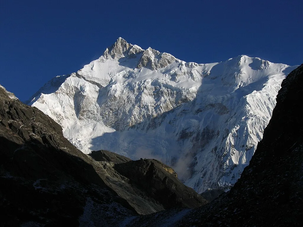
The state of Sikkim is known for its biodiversity and subtropical climates, and the Goechala trek offers the perfect glimpse of this state. The trek is known for its mesmerising 180-degree view of Mount Kanchenjunga, which is the highest peak in India and the third-highest on Earth. It passes through the Khangchendzonga National Park, a UNESCO World Heritage Site, with diverse landscapes of the alpine meadows, glaciers, and subtropical forests.
The backdrop of the Goechala trek is that of the Himalayan range, with views of up to 14 other mountain peaks, including that of Mount Pandim. One of the closest expeditions of Nepal, this trail lies both in Nepal and India. It is also considered a gateway for the moiuntaineers scaling the Kanchenjunga.
One of the oldest treks in the Himalayas, the Goechala trek is a challenging experience. Starting from Yuksom, you trek through the changing terrain with majestic views of the mountain range and the rhododendron forests. With hidden surprises, such as the Samiti Lake and the hiking trail to Dzongri, the Goechala trek is highly popular among adventure enthusiasts.
At Goechala, nature’s serenity is at its finest. Trekkers experience magnificent sunrise and sunset views from the Dzongri top, enjoy the abundant natural beauty of the Rhododendrons, and relish in the calmness of this mountain pass. However, this thrilling Himalayan trek is not suitable for beginners. This 90-kilometre-long trek needs a good level of physical fitness to traverse the pass, but the experience is worth every physical and mental hurdle.
The Goechala Trek offers a navigable route all year round, yet the best time is either spring or autumn. In the spring months, you experience the rhododendrons in full bloom, while in autumn, the mountain views are the most stunning and clear. To learn everything you need to know about the Goechala trek, follow this guide until the end. Find out a detailed itinerary, the best time to visit, trek difficulty, and a few interesting facts about the route.
What makes the Goechala trek a must-visit trek?
Just like any other high-altitude trail, the Goechala trek is also a popular destination for trekkers seeking an adventure. But what makes it different and a must-visit trek? It could be the mesmerising views of the highest mountain range of Kanchenjunga or the sunrise at Dzongri. It could also be that this thrilling adventure in the Himalayas offers a serene, tranquil retreat at the glacial Samiti Lake, at an altitude of 15,700 feet. The trekking route through Kanchenjunga National Park could also be a reason why the Goechala trek is a must-visit. And finally, the beautiful monastery at Tshoka and camping by the Prekchu river at the base of Mount Pandim are the ultimate arguments in the case of why Goechala is a must-visit trek.
Now that it is clear why you must visit Goechala, find out the best trekking itinerary to get the most out of this trail.
Trek Itinerary
Drive Distance & Time: 150 Km; 8-9 hours
Altitude: 1740 m/5700 ft
The Goechala trek starts from Yuksom, so it is suitable to arrive at Yuksom one day before the trek. After you arrive at the New Jalpaiguri Railway Station, you can hire a cab to reach Yuksom. The trek to Goechala starts the next day, as reaching Yuksom would take you approximately 8 to 9 hours. The distance between NJP and Yuksom is 150 km, so sit tight for a scenic road journey.
As you drive from NJP to Yuksom, you can experience mesmerising views of the Himalayan Ranges. The pristine Teesta River runs alongside your uphill drive, reminding you of the serenity and calmness of the natural beauty. Arrive at Legship, where you will be crossing a bridge to Yuksom. This is also the last spot where you can find an ATM, so prepare yourself accordingly.
The town of Yuksom is situated in West Sikkim and holds rich cultural and historical significance. It was once the capital of Sikkim and is often known as the Gateway to Mt. Kanchenjunga. Here, you get to experience the culture of this state to the fullest. It is filled with traditions and community life that speak of the religious and cultural stories of Sikkim.
Besides the historical and cultural fables, you can also relish the comforting Northeastern cuisine. Jorthang is the right spot for this and is a common stop for travellers. From here, Yuksom is a 60-km drive away, where you can check-in for the night. You can do some last-minute shopping for the trek, or relax and rejuvenate for the ascent.
Trek Distance & Time: 8 Km; 6-7 hours
Altitude Gain: 1740 m/5700 ft to 2400 m/ 7800 ft
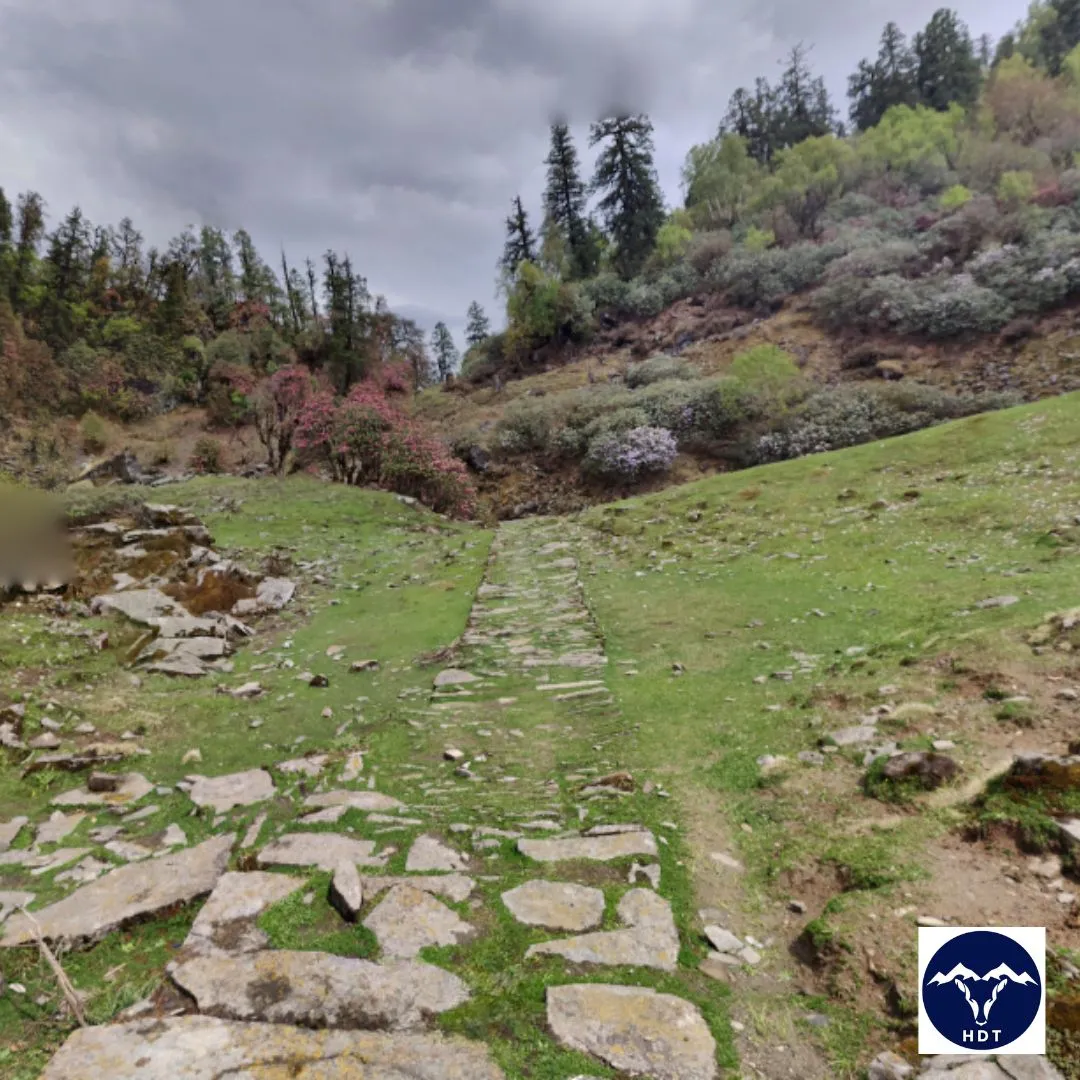
The first day of your Goechala trek starts today, so start your day early. You will be starting on an 8-km-long trek to the first campsite of Goechala, that is, Sachen. It is located at an altitude of 7,800 ft, and the ascend will take you through the canyons of the Rathong River. As you are hiking on the trail, you will come across the dense forests and thickets of the rhododendrons and Magnolias. The vegetation is so dense across this trail that you might even spot some Himalayan wildflowers and orchids on the way.
The trek starts from Yuksom, so you will notice that through the gradient, civilisation slowly ebbs away. Apart from a few mud houses in the beginning, you will be fully walking through dense forests, reminding you of the significance of nature. You also lose your mobile network coverage, and there are no shops on the way, so pack your food accordingly.
After continuing walking for a few minutes, you come across the pristine and calm Rathong River, mesmerising you with its scenic beauty. However, this trail is full of surprises, and you will eventually come across three ancient bridges on your path to Sachen. Then, you encounter charming glimpses of valleys, orchid blooms, rivers, and the Tshushay Khola waterfalls.
The difficulty level of this trail is varying. As you reach the first suspension bridge over the Pha Khola, the trail is a gentle climb. The next hour and a half to the second bridge is moderate too. During this, you come across the Tshushay Khola falls, a series of smaller falls, and ultimately they join the Prek Chu river below. The next ascent to the third bridge (over the awe-stricking Mentogang river) is steep, and after crossing it, you are at an altitude of 7000 ft. From here, a final 20-minute trek, and you have reached the Sachen campsite! Set up your tent and let the faint sound of the Prek Chu River lull you to a relaxed sleep.
Trek Distance & Time: 7 Km; 5-6 hours
Altitude Gain: 2400 m/7800 ft to 3000 m/9800 ft; via Bakhim at 2650 m/8650 ft
Wake up to the serenity of the Sachen campsite and continue to your next one at Tshoka. This trail takes you through Bakhim as you reach a total altitude of 9800 ft. The terrain nature is one of a kind, as you witness the rhododendron vegetation, dense forests, magnificent views of Mt. Pandim, and serene rivers all through this 5-hour trek.
The hike up to Tshoka starts as you cross the bridge across the Prek Chu river. Then, the trail climbs through the dense mixed forests of oak and rhododendron, as you witness them in full bloom with changing hues of the forest. At the midpoint of the trek, you can take a short break at Bakhim. Here, the Forest Rest House offers magnificent views of the Yukson Valley, and you can enjoy some light snacks at its tea stall.
Following your rejuvenating rest at Bakhim, you can continue your trek to Tshoka. From here on, the trail comprises steep ascents and descents, and finally you reach an altitude of 9000 ft. Hence, even if the trek from Sachen to Tshokha is just 7 km, the steep ascent of this technically difficult path takes up a lot of your time. Tshoka houses a beautiful monastery and is a popular spot among trekkers. The view of the snow-clad mountains and some flat plains is the right spot to set your campsite here for tonight.
Trek Distance & Time: 9 Km; 8-9 hours
Altitude Gain: 3000 m/9800 ft to 3950 m/13000 ft; via Phedang at 3700 m/12,100 ft
Wake up to the snow-clad mountains at Tshoka and get ready for an even more scenic trek to Dzongri: the lush rhododendrons springing up everywhere on your trail, the changing views of the Pandim and the Kabru ranges, prayer flags lining up the route, and the ultimate view of the mighty Kanchenjunga from Dzongri. This 9-kilometre trek is not just charming but also strenuous for trekkers; hence, it requires the utmost preparations.
The trek starts from Tshoka, and Phedang offers a welcome rest from the steep and rocky ascent. Trekkers usually choose to have their lunch here and then continue to Dzongri. The initial part of the trail begins with small rhododendrons along the slope, with wooden logs. The prayer flags at Phedang mark the spot of your well-deserved rest.
This trail section can be a test of fitness if you are not well prepared, as it is one of the most challenging days of the Goechala trek. The sharp altitude gain combined with the initial wooden trail and the rocks and pebbles can be a bit challenging for trekkers. The steep ascent often results in nausea, headaches, and other altitude sickness, so it is vital to prepare yourself. To avoid injury on this trail, you should always carry sturdy waterproof boots with soles and heavy socks.
Dzongri is your campsite for the day, so you can acclimate yourself to the altitude. The wind can be pretty chilly, so dress accordingly. The challenging climb requires much-needed rest, so relax here.
Trek Distance & Time: 1.5 km; 1-2 hours
Altitude Gain and Loss: 3950 m/13000 ft to 4150 m/ 13675 ft, and back to 13000 ft
Your body needs time to acclimatise itself to the steep climb; hence, today is a rest day. All you need to do is relax and take small walks to get used to the altitude. A small trek to Dzongri Top does the job well.
The trek should be early in the morning, so you can enjoy the sunrise view from the Dzongri Top. It takes only an hour from Dzongri, but the views of Kanchenjunga and Singalila are fantastic. The illumination of the snow-covered mountain as the sun’s rays hit it is thrilling. The scenic landscapes act as a relief from the tiring day before, and you can admire the natural beauty to your heart’s content.
A few prominent Himalayan peaks you can witness include North and South Kabru, Kanchenjunga, Mt. Pandim, Jupono, Simmo, Frey Peak, Kokthang, Narsing, and many more. From here, you can even spot your destination for the next day, that is, Thansing.
Trek Distance & Time: 10 Km; 5-6 hours
Altitude Gain and Loss: 3950 m/13190 ft to 3900 m/12910 ft; via Kokchhurung at 3650 m/12100 ft
The trek from Dzongri to Kokchhurung is gentle with medium ascents and descents. Continuing to Thansing along the Prekchhu River is also not strenuous. This 8-kilometre trail is almost at the same altitude, so 5 to 6 hours are sufficient to complete it.
As you start on the trail, lush meadows and the rhododendrons accompany you again. You will find a variety of birds camouflaged here, so this is a popular spot for bird-watching. After crossing the forest, you will gradually descend to Kochhurung. Here, the trekker’s hut and the bank of the Prekcchu river make a fine spot for resting.
Following your serene rest at Kokchurung, a straight trek to Thangsing offers some charming views too. Throughout the 2 km, you can enjoy the rhododendrons blooming and the view of the nearing Thangsing meadows. The campsite at Thangsing is located at an altitude of 13000 ft and at the foot of the majestic Mt. Pandim. Witness the magnificence of this mountain range up close and rest in the camps for the night.
Trek Distance & Time: 4 Km; 3-4 hours
Altitude Gain: 3900 m/12910 ft to 4150 m/13600 ft
The trek from Thangsing to Lamuney is the easiest day due to its gentle slopes and shorter distance. You will reach the Lamuney campsite in about 3 hours, making it a leisurely walk. It helps you acclimate yourself to the altitude and gives your body some rest.
The trail is beautiful as you walk through meadows and pastures and is mostly flat. However, the last leg is steep and rocky, causing a bit of discomfort for trekkers. From here, you can visit the Samiti Lake, which is only at a distance of 2 km. The trek to this beautiful still water lake is not as smooth but is covered with stones and pebbles. It is also important to note that you cannot camp beside the lake and would have to return to the campsite before night. Enjoy the view of the sky filled with stars at the Lamuney campsite and prepare for the early start tomorrow.
Trek Distance & Time: 18 Km; 13-14 hours
Altitude Gain: 3900 m/12910 ft to 4150 m/13600 ft
Wake up early because today’s trek is the longest and toughest day. Today is the day when you finally make your way to the Goechala Pass. First, you could start with hiking for a short time to visit the Samiti Lake. Then, you can start your ascent to reach the Goechala Pass viewpoint 1. Following the Goechala pass, you will descend and return to Thangsing or Kokchhurung, making day 8 a strenuous and equally thrilling day.
Starting the day as early as 1 in the morning is advised to avoid any harsh weather conditions. Since the trek is around 18 km long and takes approximately 13 to 14 hours, the more time you have on your hands, the better. Additionally, the remarkable sunrise views in the Himalayas add to the benefits of waking up early today. The trek starts from the Lamuney campsite to the Goechala view point, and you would have to return to the Lamuney campsite for your lunch. Then, starts the descent for lower campsites.
If you are starting at 1pm, you will reach the Goehcala view point by sunrise, so you are trailing most of the night. It is therefore recommended to carry a head torch here. As you reach the Samiti Lake, the slope will only become steeper until the Goechala viewpoint at 15,100 ft. The distance between Lamuney and Goechala is about 5 km, but it takes 3 to 4 hours to complete the steep climb.
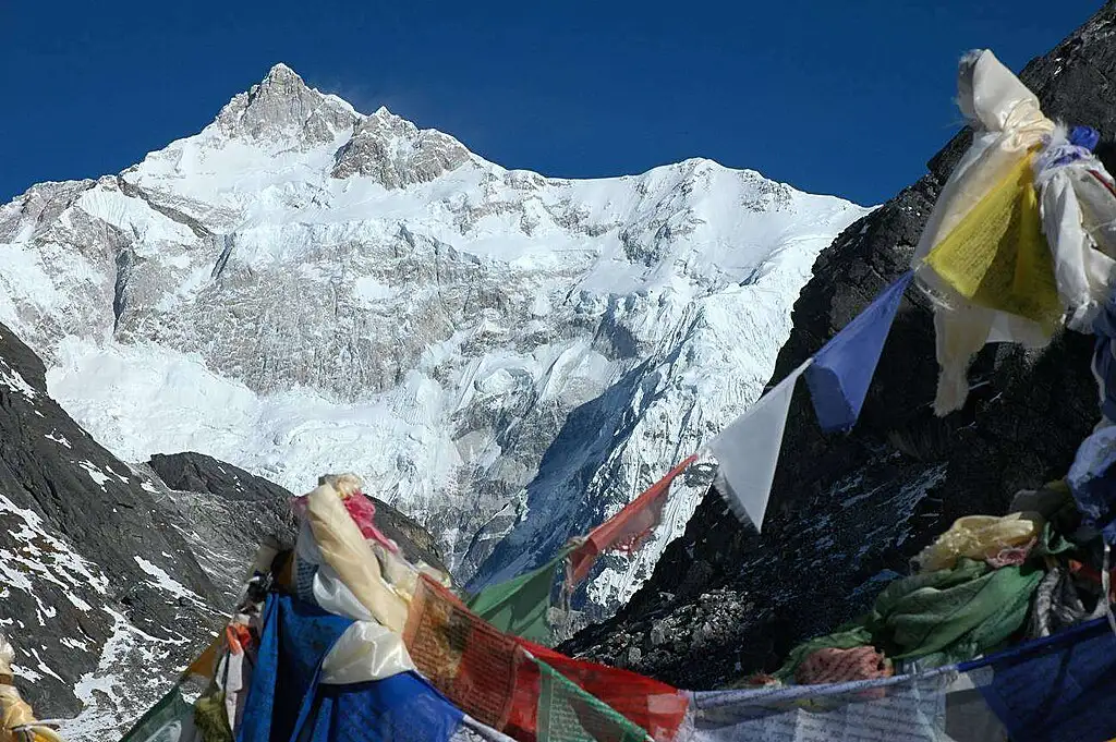
The sunrise view at Goechala is one of the most magnificent you will ever see. Witness the majestic Mt. Kanchenjunga in all its glory as the sun hits the snow-covered peaks and colours it golden. You can even spot some other major peaks, such as Pandim, Gopcha Jupano, Sinvo, Tenzing Khang, North and South Kabru, and the Kabru Dome. Revel in the accomplishment of completing your Goechala Summit, with the mountain peaks surrounding you in your celebration.
Following the Goechala viewpoint, you will begin your descent towards the Lamuney campsite. Here, you can relax for a bit and enjoy a warm lunch. Depending on the weather, you can descend further to either Thangsing or Kokchuurung and rejuvenate for the night there. Overall, the trek is overwhelming for your body, as the hiking route is moderately challenging. The nighttime adds to the strenuous uphill climb even more. The return journey is comparatively easier but depends on the weather.
Trek Distance & Time: 16 Km; 7-8 hours
Altitude Gain: 3900 m/12910 ft to 3000 m/9800 ft; via Phedang at 3700 m/12,100 ft
This 16 km long trek is your path back to Tshoka from Thagnsing. It takes around 7 hours to complete and can be steep at certain places. Depending on the weather conditions, you could find some sections frozen in ice as well. During the spring months, however, the path is filled with rhododendron blooms.
Start your day early so you can complete your descent by nightfall. You will reach Phedang after about 4 to 5 hours of walking. The trail will once again offer you some majestic views of the mountains and the dense rhododendron forests. After Phedang, there are no steep spots, so the walk is pleasant, and the beautiful mountains enhance the enjoyment. Catch a few mesmerising sightings of Mt. Pandim as you descend to Tshoka. The serenity of nature is sufficient to revitalise you from the previous strenuous day of trekking. Set your camp at Tshoka and relax before the long walk of day 10.
Trek Distance & Time: 15 Km; 7-8 hours
Altitude Gain: 3000 m/9800 ft to 1740 m/5700 ft; via Bakhim at 2650 m/8650 ft and Sachen at 3000 m/9800 ft
Today you will be reaching Yuksom as you cross Bakhim and Sachen, starting from Tsokha. You will also be crossing the Prek Chu River and enjoying a scenic trail. Since you will be mostly descending, the trek is less tiring, and you will be covering a distance of 15 km in around 7 to 8 hours.
Starting from Yuksom, you will pass through Bakhim and Sachen. The trail offers the backdrop of the snow-covered Himalayas, and the pristine Prek Chu River is visible too. After Sachen, the trail will have some ascends and descends, but the altitude will be gradually declining. Cross the three-iron bridge once again and finally reach the town of Yuksom. Here, the telecom networks will return, so you can connect with your family and friends.
Besides resting at Yuksom, you can also explore the town. Learn about the local culture, the heritage, history, and religious beliefs of the natives. The locals of Yuksom are friendly and welcoming, so the interactions are always memorable. You can even visit the monasteries or shop for souvenirs to commemorate your thrilling trek.
Distance Distance & Time: 150 Km; 8-9 hours
This is the last day of your Goechala expedition as you drive back to NJP. Start the day early so you can reach the station on time. The distance is 150 km from Yuksom to NJP, and traffic could cause delays in your schedule.
Follow the same scenic route as the Teesta River flows by your side. You can stay at NJP for the night so you can explore the local Hong Kong and Bidhan markets. Reminisce about the beautiful mountains and the lush forests as you catch a flight or train back to your city.
Package Details
Price Inclusion
Accommodation for 10 nights: Stay is included from Day 1 to Day 10 (base camp to base camp).
Meals: Meals from dinner on Day 1 to breakfast on Day 11 are included.
Trek Equipment: All essential trek equipment is included, such as sleeping bags, kitchen and dining tents, utensils, mattresses, personal tents, toilet tents, and crampons (if needed).
Forest Entry and Permits: All required fuel charges, tolls, forest entry fees, and permits are covered.
Experienced and Certified Guides: A qualified, professional team, including a mountaineering-certified trek leader, guide, cook, and support staff, will accompany you.
Emergency Kit: First aid medical kits, oxygen cylinders, and stretchers are provided to ensure the safety, comfort and well-being of all participants.
Trek Certificate & HDT Badges: Receive a trek certificate and HDT badges to celebrate your adventure.
GST (5%): Included in the package cost.
Price Exclusion
Meals during Transfer: Meals are not included while traveling to and from the trek starting points.
Emergency Evacuations: Any charges related to emergency evacuation are not included.
Personal Expenses: Any meals or accommodations outside of the provided itinerary or additional services not listed in the inclusions.
Transport: Transport facility for an extra charge
5% GST
Best Time to Visit for this Trek
The beautiful state of Sikkim is known for its moist weather conditions that are prevalent almost throughout the year. The increasing altitude also adds up to the dampness along with the natural cold conditions. So, even though the Goechala trek can be done throughout the year, some weather conditions offer a more pleasant experience than the others. The weather you will be experiencing at Goechala will depend on the seasons.
For the Goechala trek, the best time is the one that suits your preference. Late June to early September at Goechala should be avoided due to the heavy storms common in these months. From September to December, you witness the best views of the mountains with mesmerising sunrises and sunsets. On the other hand, April and May are flower-blooming months, with the beauty of Rhodedendrons and Giant Magnolias.
Find out detailed information on the ideal months to visit Goechala below:
Spring (April to May)
| Attribute | Details |
| Temperature Range | 12° C to 15°C during the day |
| -3°C to 0°C at night | |
| Weather | Pleasant trekking conditions with cold air and some snowfall. |
| Clothing layer required | Upto 3 warm layers: Thermal inners with fleece over and a jacket |
| Ideal for | Comfortable and pleasant trekking; serene rivers and calm nature. |
| Special features | Lush forests with blooming rhododendrons belt from Tshoka to Phedang, bird-watching activities, and diverse Kanchenjunga National Park. |
The Goechala trek is at its peak during the spring/summer season. The weather conditions are most favourable for trekking and tourist activities. For snow enthusiasts, there are some patches of snow at the higher altitudes. You might even witness snowfall during this season, as it drapes the upper areas of meadows in white. The blooming rhododendrons are in various hues, from pink to scarlet and even white. The rich biodiversity of Knachenjunga National Park adds to the experience.
The daytime temperatures are comfortable for trekking, with some cold wind blowing to remind you of the higher altitudes. The temperature during the day ranges between 12° and 15° C; however, at night, it can drop up to minus 3° C. The weather is stable with fewer rainfalls, making it a comfortable time for the Goechala trek.
Autumn (October to November)
| Attribute | Details |
| Temperature Range | 8° to 12° during the day |
| -5° to -10° at night | |
| Weather | Chilly and sometimes sub-zero temperatures at night, with cold winds blowing during the day. |
| Clothing layer required | Up to 5 warm layers: heavy thermals and fleece outer with windproof and padded jackets. |
| Ideal for | Drak lush forest views under the clear autumn sky; clear views of Dzongri, Thangsing, Tshoka, and Goechala Viewpoint 1; night-sky photography. |
| Special features | Vibrant landscape, serene and clear air, trekking under the star-lit sky. |
Another best time to visit Goechala is the autumn season. The weather conditions are clear with no haze, offering sharp views of the Knachenjunga, Pandim, and other major peaks. There are no blooming rhododendrons, but the landscape is filled with dark, mossy forests. The colours are vibrant in contrast to the blue sky, with hues of deep reds and browns seen in the forests. The season is also ideal for stargazing, as the pristine, clear night sky is lit with the stars.
The environment in Goechala is colder during the autumn season with plummeting temperatures. During the day, the temperatures range between 8° and 12° C. At night, the temperatures drop up to minus 10 °C. The weather is undoubtedly chilly, but trekking is comfortable. With appropriate clothing, you can protect yourself from the cold winds while enjoying the weather.
Difficulty Level of this Trek
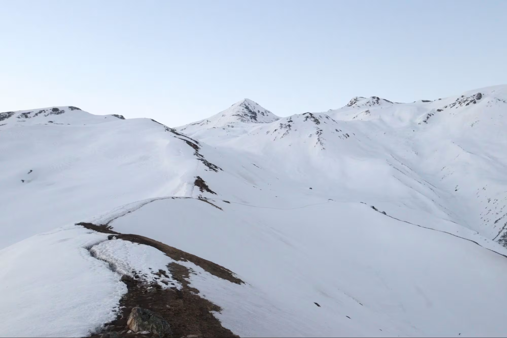
The Goechala trek is considered a moderately difficult trek because of its maximum altitude of over 15000 ft. The trek is ideal for high-altitude trekkers as it ascents rapidly with long and strenuous walks. The trail, however, is safe, with well-laid out and wide paths requiring no special skills or navigation. The quick climb of the Goechala trek makes it difficult for beginner trekkers to become habituated to the sudden altitude rise. Hence, prior experience of trekking is vital for faster acclimatisation to the altitude.
Trekkers often face acute mountain sickness due to the sudden climb of the Goechala trek. The acclimatisation day at Dzongri is therefore greatly important for your safety. Dzongri is also an exit point for those suffering from altitude sickness, because after this, the altitude goes beyond 15000 ft and might even add to the symptoms. The following are some factors that make the Goechala trek a difficult one:
Terrain.
The terrain of the Goechala trek is relatively easier compared to the other high-altitude treks of the Himalayan region. Although it takes you beyond 15000 ft through a rapid climb, the trail is safe. The entire route is well laid out and wide, with only a few zigzag paths. While trekking, you will cross streams and waterfalls, along with the three iron bridges between Yuksom and Sachen. The only issues you will face on this terrain are the high elevation and a few difficult pathways. Some rough roads increase the chances of slippage, so trekkers need to be fit with some prior experience.
Walking Distance and Altitude Gain.
The total distance you will cover on your way to Goechala is approximately 40 km. So, you are trekking for a distance of 80 km to and from Yuksom. This overwhelmingly long trekking distance makes the Goechala trek moderately difficult. The trail strains your body, but the topmost point of Goechala and the majestic views are enough to make you forget the long distance. However, using quality boots especially designed for trekking and hiking is a must to avoid any injury during the trail.
The rapid altitude gain is another factor adding to the difficulty level of the Goechala trek. The second day itself starts from an altitude of 5700 ft. When you reach the Goechala summit, you are at an altitude of 15100 ft. This is why the acclimitation day at Dzongri is essential to avoid acute mountain sickness and enjoy a comfortable trek.
Weather and Temperature.
The most suitable time to visit Goechala is during the spring and autumn seasons. Although Goechala is open to visitors throughout the year, heavy storms are common during late June to early September. Hence, we suggest avoiding these months while attempting the Goechala trek. The monsoon increases the chances of landslides, and the soil is slippery, along with the dampness in the weather. This makes trekking not only dangerous but also uncomfortable.
Trek Essentials
The best time for Kedarkantha Trek is during the winter months, especially from December to April, when the entire trail is covered with snow.
- 45-60 Ltr Bag Pack With Rain Cover & Comfortable Straps
- Hot and Cold Water Bottle Like Borosil and Milton
- Energy Bar, Dry Fruits, and ORS
- Personal Medical Kit
- 1 Pair of Sunglasses (UV Protected)
- 1 Neck Gaiters (Buff)
- Tiffin Box
- 2/3 Full Sleeves (Non-Cotton)
- 1 Full Fleece T-Shirt
- 1 Fleece Jacket (Woolen or Sweater)
- 1 Down Feather/ Hollofil Jacket
- 1 Waterproof Jacket/ Poncho
- 1 Pair of Thermal Inners (Upper and Lower)
- 2 Trek Pants (Avoid Shorts and Denim Pants)
- 1 Pair of Waterproof Gloves
- 1 Pair of Woolen Gloves
- Sun Cap
- Woolen Cap
- 4 Pairs of Cotton Socks
- 1 Pair of Woollen Socks
- 1 Waterproof and High Ankle Trekking Shoes
- 1 Pair of Floaters
- Hand Sanitizer and Sunscreen Lotion
- Toothbrush and Toothpaste
- Toilet Paper
- Quick Dry Towel
- Lip Balm and Antibacterial Powder
- Moisturizer
- Aadhaar Card, Pan, or Passport for Applying Permit
- Trek Insurance
- Medical Certificate
- Self-Declaration Form
- Sleeping Bag
- Common Tent
- Mattress
- Dining Tent
- Camping Stool
- Walkie Talkie (For Team)
- Utensils
How To Reach Base Camp
The Goechala trek starts and ends in Yuksom. So, before starting on your trek, you would have to reach the base camp here. Yuksom is about 150 km from the New Jalpaiguri Railway Station, the city of Siliguri, and the airport at Bagdogra. To reach NJP, Siliguri, or Bagdogra, you can choose train or flights. Your mode of transportation decides where you will reach.
By Air
Bagdogra is the closest airport to Yuksom. It is Siliguri’s airport and has good connectivity with Kolkata, Mumbai, Delhi, Hyderabad, and Bangalore by air. Book your flight tickets in advance to avoid higher prices and reach Bagdogra on Day 0 to reach the Yuksom Base camp on time.
By Train
The station of Siliguri, that is, NJP, is where you will reach if you choose to come by train. NJP, or the New Jalpaiguri Railway Station, mostly has trains coming from Kolkata. The North East bound trains that come from Delhi reach directly at NJP. These trains are usually booked rapidly, and getting seats is challenging. So, we advise you to book your tickets in advance.
By Bus
Most of the time, the trains and flights are expensive and booked fully. In such situations, you can fly to Kolkata and then book a bus to Siliguri. Although the journey is 14 hours long, there are sleeper buses available, and the route is comfortable.
Once you have reached Siliguri, you can reach Goechala by either booking a cab directly to Yuksom. You can also take a bus up to Jorethang and then hire a vehicle for Yuksom. The 87-kilometre drive from Siliguri to Jorethang takes approximately 4 hours. Then, Yuksom is another 4-hour drive from Jorethang. It is important to remember that the last vehicle for Yuksom will leave before 2.00 pm. Hence, we advise you to leave Siliguri as early as possible to reach Jorethang around noon.
Although the months between December to February are the coldest and the temperature remains below zero at night, this is the time when the landscape around the trail turns into a wonderful paradise.
Though these months are mostly cloudy, if you are lucky, you can enjoy the bright landscapes under clear skies. The campsites are covered in a blanket of snow, and near Judha Ka Talab, trekkers can even walk on the frozen lake.
Though these months are mostly cloudy, if you are lucky, you can enjoy the bright landscapes under clear skies. The campsites are covered in a blanket of snow, and near Judha Ka Talab, trekkers can even walk on the frozen lake.
More Info About this Trek
Cultural and Historical Info
The Goechala trek, amidst the enchanting views, also has a rich cultural and historical heritage. As history claims, a famous French mountaineer, Pierre Noire, was the first to open the Goechala trek for the public in 1979. Since then, this trail has been a popular choice among trekkers worldwide. During the colonial rule in India, the British discovered Goechala as a trade route from Sikkim to Tibet.
Yuksom, the base camp of the Goechala trek, is another historically rich town. It was the first capital of Sikkim during its creation in 1642. The town also holds religious value for the natives of Sikkim. It is especially significant for the Coronation Throne of Norbugang and marks the first Chogyal. The Chogyal is the Royal Spiritual King of Sikkim, and Yuksom was the place where the first Chogyal was enthroned. In some myths, it is said that the famous saint Guru Padmasambhava descended at Goechala on a legendary tigress. He is often called the Second Buddha, and since then, the Goechala summit has become sacred.
According to the indigenous culture of Sikkim, Mount Kanchenjunga is regarded as a guardian deity. In Tibetan, Kanchenjunga means ‘five treasures of the great snow’, which is a reference to the five peaks of this range. It is a belief that no one has ever stood on the summit of this majestic mountain. On May 25th, 1995, Joe Brown and George Band were the first to climb the peak; however, they stopped a few feet below the summit. The then Chogyal ruler allowed them to embark on their expedition. But he put forward the condition that they would not climb the peak, as it is home to divine forces. Since then, as a testament to the rules and the divine forces present there, no one has even stepped on the summit.
In the local language of Limbu, Goechala translates to ‘Land of Snow’. As beautiful as the Goechala summit is, the culture is warm and welcoming too. The trek passes through areas where the original inhabitants of the region reside, the Lepcha and Bhutia tribes. Through the trek, you can learn a lot about their traditions. The Buddhist monasteries are a great way to witness the region’s culture. The carvings and statues on the onastries display the spirituality and history of the region. The welcoming nature of the locals makes it easy to interact with them and learn about their customs and traditions. Local festivals, such as the Losar (Tibetan New Year) and the Saga Dawa (Buddha’s birthday), are worth participating in too.
A big part of the Goechala trek is learning about the lives of the local communities. Talking to them will make you feel one with the people and the culture. It makes your trek more spiritual, meaningful, and unforgettable.
Flora and Fauna
The flora and fauna found along the Goechala trek is one of the most diverse ones. The trail crosses three different vegetation zones. Huge varieties of the rhododendrons, fir, oaks, maple, shrubs, and birch are common along the trail. Trekkers can also enjoy the views of the alpine meadows and rocky areas. The route even has an abundance of medicinal plants, and local people use them for medication.
The Goechala trek is also home to several native animals, such as the red panda, snow leopard, musk, deer, sloth bear, wild dog, Tibetan wild ass, serow, and the Himalayan black bear. Plus, there are around 550 species of birds here. Some might even say that the Yeti is a common sight on the Goechala trek (however, others believe it to be a myth). The state has taken initiatives to protect the plants and animals of this region (except maybe the Yeti). Trekkers are also supportive of such initiatives and practice mindful trekking to preserve the beauty of the trail.
Special Casual Leave for Trek
Himalayan Dream Treks (HDT) is registered tour operator with the IMF, and we can cater to the needs of SCL for Government Employees. According to the rule, the government of India provides its employees with a prospect where they’re allowed to apply for a 30-day special casual leave in a calendar year to do trekking, hiking, or whatever adventure pleases them.
Mail us at info@himalayandreamtreks.in, if you want to avail SCL.
Although the months between December to February are the coldest and the temperature remains below zero at night, this is the time when the landscape around the trail turns into a wonderful paradise.
Though these months are mostly cloudy, if you are lucky, you can enjoy the bright landscapes under clear skies. The campsites are covered in a blanket of snow, and near Judha Ka Talab, trekkers can even walk on the frozen lake.
Nearby Attractions
The following are some nearby attractions to visit during the Goechala trek:
- Dubdi Monastery: It is a 400-year-old monastery known for its carvings and paintings of Buddhist saints.
- Tashi Tenka: An old royal palace complex. Currently, it is in ruins, but it offers a 360-degree view of the Yuksom valley.
- Kheceopalri Lake: A heavenly water body meaning ‘the heaven of Padmasmabhava’. It is one of the largest lakes of the state and is sacred to both Hindus and Buddhists.
- Kanchenjunga National Park: A UNESCO World Heritage Site. It houses various endangered species, and there are even some settlements of the Lepcha tribe inside the park.
- Tholung Monastery: It is located inside the Kanchenjunga National Park. It is one of the oldest and most sacred monasteries in the state.
Although the months between December to February are the coldest and the temperature remains below zero at night, this is the time when the landscape around the trail turns into a wonderful paradise.
Though these months are mostly cloudy, if you are lucky, you can enjoy the bright landscapes under clear skies. The campsites are covered in a blanket of snow, and near Judha Ka Talab, trekkers can even walk on the frozen lake.


Leave a Comment