
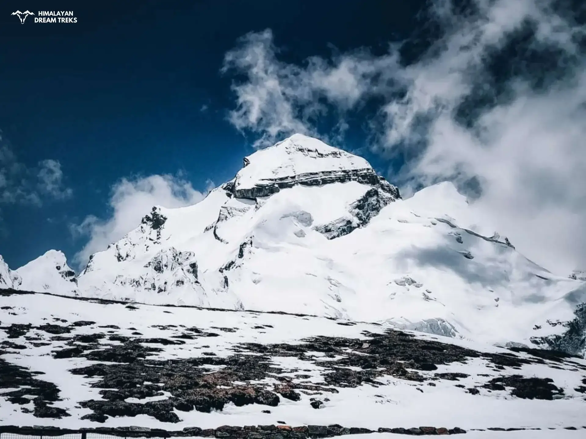
Adi Kailash, also known as Shiva Kailash, Chota Kailash, Baba Kailash, or Jonglingkong Peak, is a sacred mountain located in the Pithoragarh district of Uttarakhand, India. Standing at approximately 5,975 meters (19,600 feet), it holds the distinction of being the second most important peak among the Panch Kailash or “Five Kailashas” of the Himalayas. The five sacred peaks in order are:
- Mount Kailash (Tibet)
- Adi Kailash (Uttarakhand)
- Shikhar Kailash/Shrikhand Mahadev (Himachal Pradesh)
- Kinnaur Kailash (Himachal Pradesh)
- Manimahesh Kailash (Himachal Pradesh)
This sacred peak invites devotees all over the world with its striking resemblance to Mount Kailash in Tibet. You will also find two glacial lakes, Gauri Kund (also known as Jolingkong Lake) and Parvati Tal, which rests at the base of Adi Parvat near Jolingkong, adding more to its spiritual significance.
Most devotees visit Nabidhang as well to witness Om Parvat (5,590m/ 18,340ft). Here on this mountain, the surface is carved in the shape of the sacred Hindu symbol “ॐ,” pronounced as “Om.” The embossed Om stands out more predominantly because falling snow enhances the structure. It is believed that there are a total of eight mountains like this, carved by the almighty Lord Shiva himself, but only one has been found till now.
Apart from spiritual reasons, the enticing peak of Adi Kailash attracts trekkers worldwide to witness its glory. The journey will offer you varying challenges with constant scenic routes based on the chosen routes. You will pass through some of nature’s best creations, like Darma Valley, Kuthi Yankti Valley, Sin La Pass, Nama Pass, etc.
Let’s understand more about Adi Kailash Parvat Yatra, its significance, trekking routes, and more.
Table of Contents
Geographical Location and Features
Location
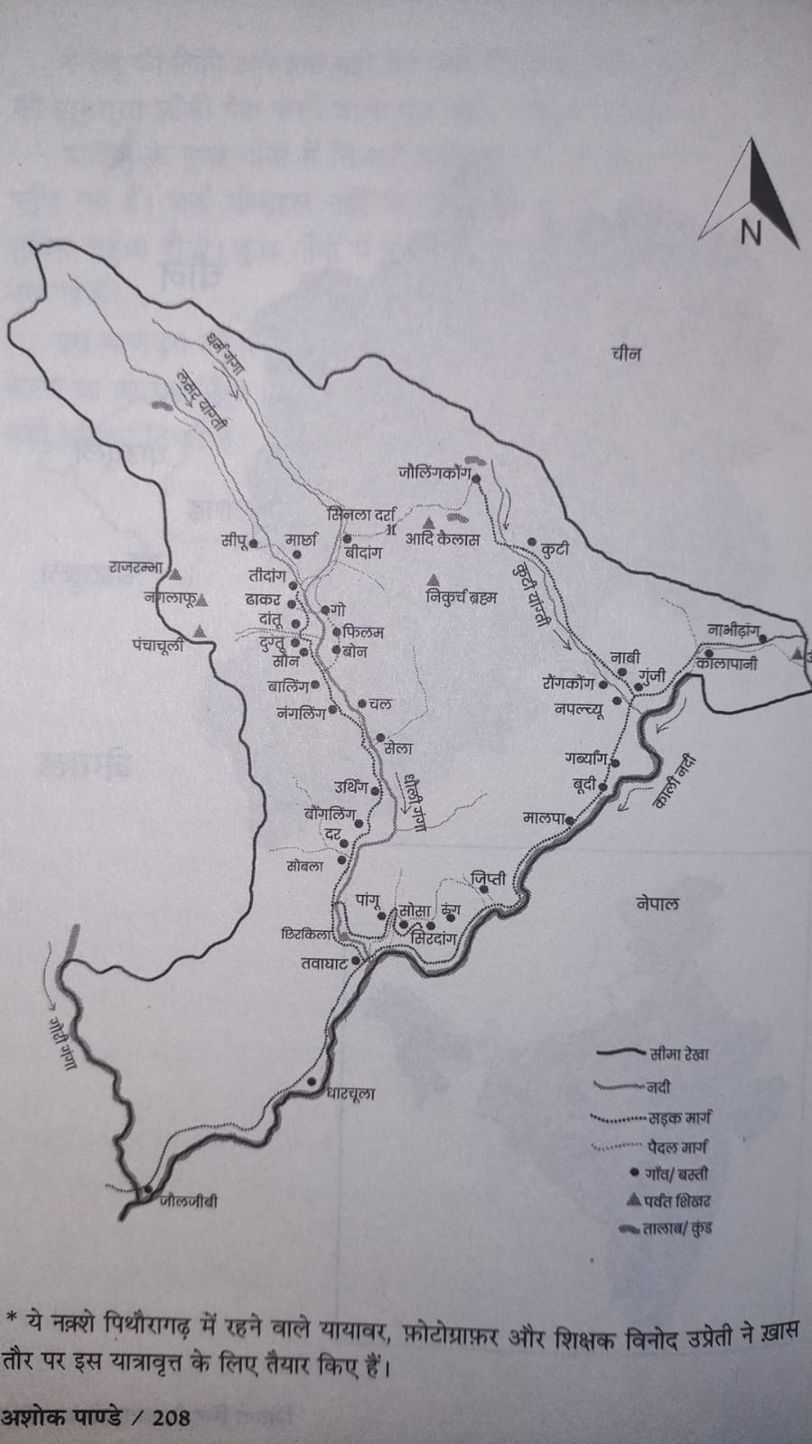
Adi Kailash is nestled in the eastern part of Uttarakhand, close to the India-Nepal and India-Tibet borders. It lies at an altitude of approximately 6,191 meters (20,312 feet) at coordinates 30°19′09″N 80°37′57″E and is part of the Kumaon Himalayas. The trek to Adi Kailash passes through the Darma Valley and the Kali River Valley, offering glimpses of high-altitude landscapes, dense forests, river crossings, and remote villages rich in cultural heritage.
- Situated in the easternmost mountain wedge of Uttaranchal state
- Squeezed between the borders of Tibet and Nepal
- The massif is bound on the west by the Darma Valley
- The eastern boundary formed by the Kuthi Yankti-Kali Ganga rivers
- Base camp located 17 km northwest of Kuthi (Kuti) village in Kuthi Yankti Valley
- Northwest of Gunji, with Limpiyadhura Pass further northwest
- Proximity to Lipulekh Pass, Old Lipulekh Peak, and Om Parvat (which lies northeast of Gunji)
Geographical Features
- Peak elevation: approximately 5,975 meters (true height verified during the first ascent)
- Two sacred lakes at the base: Gauri Kund (Jolingkong Lake) and Parvati Tal
- Formed of vertically folded crushed sediments, including limestone bands
- Fossil bands (mainly ammonites) found up to 5,500m elevation
- Rich biodiversity with alpine meadows
- Dense forests in lower regions
- Varied terrain from moderate to challenging gradients depending on the route chosen
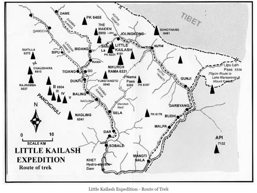
Different Trekking Routes & Itineraries for Adi Kailash
The journey to Adi Kailash offers multiple trekking routes suitable for intermediate trekkers, challenging paths for experienced ones, and serene stopovers at quaint villages with scenic landscapes.
Depending on the chosen path, trekkers can experience high-altitude challenges, valleys, rivers, water streams, cultural interactions in remote Himalayan villages like Gunji, Kuti, and Nabi, and, of course, beautiful views of snow covered peaks.
Route 1: Classic Circuit (7 Days)
This is the most commonly used route, also preferred by non-trekkers as a motorable road has been constructed till Jolingkong itself. So you can drive all the way to Adi Kailash base camp with trekking.
However, trekkers can follow the same route and conquer it old-fashioned. Don’t worry; you will find many cozy homestays in these villages for your stopover.
Itinerary 1
Day 1: Kathgodam (554m) to Pithoragarh (1,627m/ 5337ft)
- Distance: 220 km | Time: 8-9 hours
Day 2: Pithoragarh to Dharchula (915m/ 3002ft)
- Distance: 85 km | Time: 4-5 hours
Day 3: Dharchula to Gunji (3200m/ 10498ft)
- Distance: 70 km | Time: 6-7 hours
Day 4: Gunji to Nabhidang (4300m/ 14,107ft) and Back (Om Parvat Darshan)
- Distance: 16 km | Time: 8-9 hours
- Terrain: Moderate to challenging
Day 5: Gunji to Jyolingkong (4700m/ 14,107 ft) and Back (Adi Kailash Darshan)
- Distance: 20 km | Time: 10-12 hours | Terrain: Challenging
Day 6: Gunji to Dharchula
- Return journey
Day 7: Dharchula to Pithoragarh
- Final return leg
Itinerary 2: Extended Circuit (8 Days)
This route includes additional destinations and attractions for which we suggest taking a taxi/bus service.
Days 1 to 5: Same as Route 1
Day 6: Gunji to Chaukori (2,010 m/ 6,594 ft) via Dharchula
- Distance: Approximately 180 km | Time: 7-8 hours
- Key attractions:
- Panoramic views of Nanda Devi, Panchachuli peaks, and Nand Kot.
- Tea gardens
Day 7: Chaukori to Bhimtal (1370m/4495ft ) via Patal Bhuvaneshwar (1350m/4429ft )
- Distance: 172 km | Time: 5-6 hours
- Special attractions: Ancient limestone cave temple complex
Day 8: Bhimtal to Kathgodam
- Distance: 30 km | Time: 1-2 hours
- Leisure day
- Shopping and local sightseeing opportunities
Itinerary 3: Express Circuit – Extension to Lipulekh Pass and Kailash Mansarovar* (5 Days)
A more compact and less time-consuming itinerary for experienced trekkers because of rapid altitude gain.
Day 1: Kathgodam/Haldwani to Dharchula
- Distance: 335 km approx | Time: 8-9 hours | Mode: By road
Day 2: Dharchula to Gunji
- Distance: 71 km approx | Time: 3-4 hours | Mode: By road
Day 2: Gunji to Jyolingkong (trek) and back to Gunji (Adi Kailash Darshan)
- Distance: 25 km | Time: 2-2.5 hours
Day 3: Gunji to Dharchula via Nabidhang (Om Parvat Darshan)
- Distance: Dharchula to Nabidhang: 110 km + 20km till Gunji | Time taken: 6-7 hours
- *Optional: From Nabidhang you can extend towards Lipulekh Pass and witness the holy Kailash Mansarovar as well. Given you have proper permits and no border tension as you will need approval from Tibetan authorities.
Day 4: Gunji to Dharchula (return journey)
- Distance: 71 km approx | Time: 3-4 hours
Day 5: Dharchula to Kathgodam/Haldwani (final leg)
Route 2: The Challenging Sin La Pass Route (5 to 6 days)
For experienced trekkers seeking an adventurous and less-travelled path, the Sin La route offers a demanding but rewarding trek.
Day 1: Dharchula to Gala Village Drive (2375m/ 7792ft) and Trek to Budhi (2740m/ 8989.5ft )
- Drive Distance: 37 km | Time: 3-4 hours
- Trek Distance: 20 km | Time: 10-11 hours
Day 2: Budhi to Gunji (3200m /10,498ft)
- Trek Distance: 17 km | Time: 4-5 hours
Day 3: Gunji to Kuti (3657m/ 12000ft)
- Trek Distance: 19 km | Time: 7-8 hours
Day 5: Kuti to Jolingkong (4572m/ 15000ft)
- Trek Distance: 14 km | Time: 4-5 hours
Day 6: Excursion to Adi Kailash Darshan, Parvati Sarovar, Gauri Kund
Note: You can do it on day 5 itself, but it is advisable to give your body the rest it deserves and acclimatisation time.
Day 7: Sin La Pass (5500m/ 18,044ft) CROSSING to Bidang Village (3950m/ 12,959ft)
- Trek Distance: 35 km OR 13km | Time: It takes approximately all your day.
Sin La Pass connects Kuti Yankti Valley through Jolingkong to Bidang Village in Darma Valley. This route was traditionally used by mountain communities like Bhotia & Rang for trade to Tibet.
Day 8: Bidang to Dugtu/Dakutu (3048m/ 10,000ft) OR (3597m/ 11800ft)
- Trek Distance: 17 km | Time: 5-6 hours
Day 9: Return to Dharchula (Drive)
- Distance: 70 km | Time: 3-4 hours
As it is a long distance to be covered it is advisable to take a drive down to Dharchula.
Trekking down will take several days, depending on the rest in different villages en route.
Reverse Way
You can reverse this route and start from Dharchula to Darma Valley first and descend to Kuti Valley.
Dharchula→Sela/Nagling→Dugtu-Bidang→Sin La Pass→Jolingkong→Kuti→Gunji→Budhi→Gala→Back to Dharchula
Route 3: Via Nama Pass Trail
Nama Pass connects Sela village of Darma Valley to Kuti village through imposing Himalayan peaks. The trail used to be brimming with local people and traders to Tibet but remains mostly deserted.
The last motorable road in Darma Valley is to Dar, so, it is suggested to go up with a vehicle and then start your trek. However, if you want to, then you can begin your trek from Dharchula itself, but it will be more time-consuming.
Day1: Darchula to Sobala (1,670m/ 5,500ft)
- Distance: 37km | Time: 9-10 hours
- Sobla marks the gateway to Darma Valley
Day2: Sobala to Sela (2438m/ 7998ft)
- Distance: 17km | Time: 9-10 hours
Day 3: Sela to Kuti (3700m/ 12,300ft) via Nama Pass (5200m/ 17,060ft)
- Distance: 28km | Time: will take almost all-day
Day 4: Kuti to Jolingkong (4572m/ 15,000ft) (Adi Kailash Darshan) back to Kuti
- Distance: 20 km | Time: 10-12 hours
Day 5: Kuti to Gunji (3,200m/ 10,498ft)
- Distance: 19 km | Time: 9-10 hours
Day 6: Gunji to Dharchula (Return)
- Distance: 71 km | Time: 3-4 hours by road
Climate
- Best time to visit: May to October
- Winter months (November to April): Extremely cold and often inaccessible
- Monsoon season (July-August): Challenging due to landslides
- Temperature range: -10°C to 20°C during trekking season
The two attempts made to the peak of Adi Kailash
The First Attempt (2002):
In 2002, Martin Moran led a team of 6 members that attempted Adi Kailash via its imposing North Face. They approached through the traditional route, trekking up the Darma valley and crossing over the Sin La.
The team reached Jolingkong and was rewarded with the ethereal view of their destiny – Adi Kailash. The north-facing pyramidal peak could be distinguished from others with its striking vertical rock cutting across at 5,825m.
However, they encountered a serious problem: 55° powder snow with no bond to the bare rock slabs below, hence unstable to walk on. This dangerous condition forced them to withdraw, leaving the peak unclimbed. The unstable snow conditions on the technical terrain made it too risky to continue.
The Successful Ascent (2004):
Two years later, in 2004, a new attempt was organised by Moran but led by British guides Andy Perkins and Martin Welch with a team of seven climbers. They took a completely different approach, having learned from the previous attempt. Instead of tackling the formidable north face, they chose the Southwest Ridge (AD – grade) as their line of ascent. Other factors which worked in their favour are-
- Made their base camp at Nikurch Rama, also known as Brammah Parvat, about 2km south of Jolingkong
- Accessed the mountain through a large side valley and glacier system
- Established a high camp at 5,400m
This route proved to be much more reasonable, rated at Alpine AD (Assez Difficile) standard. The team successfully reached the summit, though, due to respect for religious beliefs, they stopped 5 meters short of the absolute top, acknowledging Adi Kailash’s sacred status as the seat of Lord Shiva.
New Discovery: It was in this attempt that the actual height of Adi Kailash was measured, which was 5975 m (19,603 ft). Earlier, it was believed to be 6191 m.
Adi Kailash represents a unique blend of natural beauty and spiritual significance in the Indian Himalayas. The recent development of infrastructure, including the new road from Gunji to Limpiyadhura Pass in July 2020, has reduced the trek time to just two hours, making this sacred site more accessible than ever before.
However, this accessibility comes with the responsibility to preserve its pristine environment and religious sanctity.
Whether approached via the traditional Darma Valley route or the newer motorable path through Gunji, Adi Kailash offers pilgrims and trekkers an extraordinary experience that combines spiritual devotion, cultural richness, and natural beauty. The multiple routing options cater to different levels of experience and time constraints.
For future visitors, as infrastructure developments have made your journey easier and more convenient, remember to respect the local customs, religious significance and be environmentally conscious to preserve this sacred destination for generations to come.


Leave a Comment