

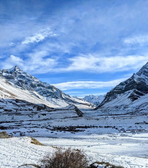
Known as “Middle Land” between Tibet and India, Spiti Valley is a high altitude destination in the northern Himalayas of Himachal Pradesh. The valley is often called a “cold desert” because it is dry and rocky, with scant rainfall and hardy terrain. Jagged snow‑clad peaks rise around a broad U-shaped river valley. The Spiti River flows through its center, carving deep gorges and flat sandbanks. The local villages here speak Bhoti (a Tibetan dialect) and practice Tibetan Buddhism. Visitors notice how quiet and open the land feels – sunlight on windswept cliffs, prayer flags fluttering in a cold breeze. The valley’s population is very sparse, and Kaza is the only large town. Summer brings short green patches along irrigated fields, but most of the year Spiti is hard rock, scree slopes, and high barren plains. This high-altitude wilderness has a stark, peaceful beauty.
Places to Visit in Spiti Valley
1. Kaza
- Elevation: ~3,650 m (11,980 ft).
- Role: Largest town and administrative HQ of Lahaul and Spiti district.
- Connectivity: Main road hub (only petrol pump is here), mobile network available (Jio/Airtel).
- Culture: A local Buddhist gompa and market at Old Kaza (Kaza Khas) sells handicrafts, woollens and everyday goods.
- Festival: Hosts Ladarcha Fair (annual sheep trading festival, mid-August).
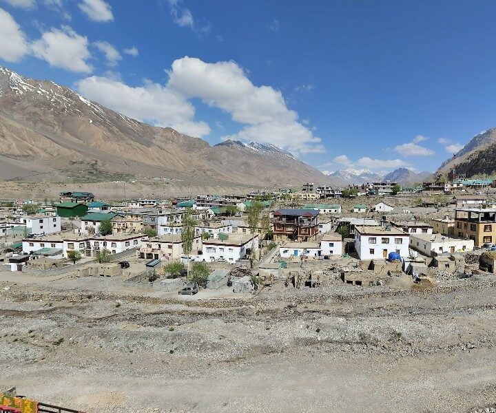
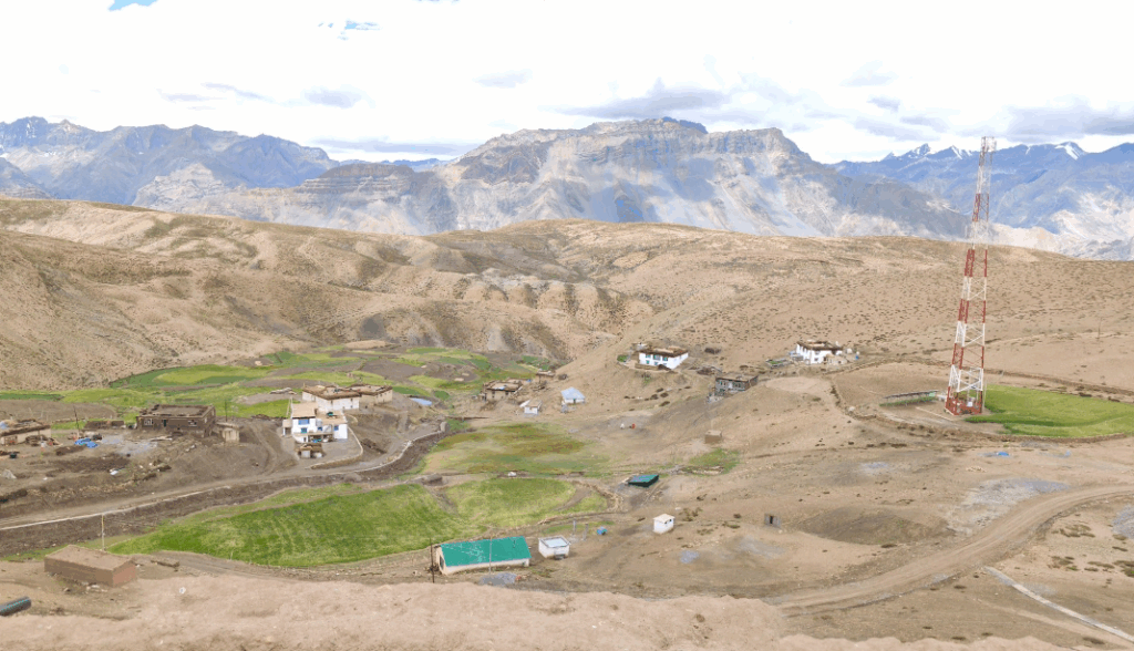
Kaza is the central base for exploring Spiti. It sits by the Spiti River and consists of two areas: the original Old Kaza (a market bazaar and gompa) and a newer settlement. From its vantage you see barren slopes and distant peaks. Travelers stay in guesthouses or homestays here and stock up on supplies. A small new tall Buddha statue overlooks the town. The marketplace is the valley’s commercial heart, full of Tibetan-style shops and a bakery. From Kaza one can visit nearby sites: the key monuments like Key Monastery (12 km away), or head into valleys like Pin and Parang with vehicles. The clear, high-altitude air gives splendid views at sunrise and sunset. Kaza’s calm town life – horses plodding through dust, locals in home‑grown wheat fields, travelers sipping butter tea – sets the relaxed tone of Spiti travel.
Also Read: Traditions and Culture of Spiti Valley
2. Key Monastery (Kye Gompa)
- Elevation: 4,166 m (13,668 ft) above sea level.
- Sect: Gelugpa (Yellow Hat) school of Tibetan Buddhism.
- History: Founded in the 11th century by Dromtön (a disciple of the guru Atisha).
- Description: Largest monastery in Spiti, with fortress-like architecture.
- Highlights: Maze of interconnected chambers and chapels; ancient murals and thangka scrolls.
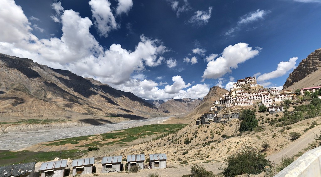
Key Monastery crowns a hilltop about 12 km north of Kaza. It is the oldest and largest Buddhist center in the valley. The monastery’s whitewashed walls and red ochre battlements make it look like a Tibetan castle against the sky. Inside, several floors of chambers unfold. Elaborate wall paintings and colorful thangka scrolls cover the interiors, telling Buddhist stories. A vaulted assembly hall holds an enormous figure of Vajradhara Buddha. Visitors can climb narrow stairs and corridors to upper terraces, where they look down over the green fields of Kaza and the winding Spiti River. In summer the light on its walls is beautiful; in winter it is snowbound. Key Gompa remains an active monastery of about 50 monks. It gives visitors a sense of age and tradition – centuries of relics, statues and sutras are still kept here. The peaceful atmosphere and the panoramic views make Key Monastery a must-see in Spiti.
3. Kibber Village
- Elevation: 4,270 m (14,010 ft).
- Unique: Once the highest motorable village in the world.
- Wildlife: Gateway to Kibber Wildlife Sanctuary (home to snow leopard, ibex, etc.).
- Attractions: Small stone gompa; green barley fields against a desert backdrop.
- Nearby: 19 km north of Kaza, linked by a seasonal bus in summer.
Kibber is a striking Spitian village at the top of a narrow spur. Surrounded by gray hills, it contrasts barren rocks with surprisingly green fields in summer. Farmers here grow peas and barley using mountain streams. The one-lane road from Kaza climbs steeply to reach Kibber. You see prayer flags and flat, stone houses. There is a modest gompa (monastery) with a low sloping roof. Tourists come to Kibber for two main reasons: first, it’s an access point for the Kibber Wildlife Sanctuary, where one can spot Himalayan blue sheep, wolves and the rare snow leopard. Second, Kibber hosts one of the world’s highest post offices – at 4,270 m, it’s famed for altitude records. (A tourist delight is mailing a postcard from here.) Nearby is the Chicham Bridge, which crosses a dramatic gorge and is one of Asia’s highest suspended bridges. Though remote, Kibber now has a few guesthouses and homestays, electricity and internet. Visitors often camp in Kibber or simply pause here en route to higher villages, enjoying its wide views and starlit skies at night.
4. Hikkim (World’s Highest Post Office)
- Elevation: ~4,440 m (14,570 ft).
- Post Office: Established 1983, at 4,400 m; likely the world’s highest post office.
- Location: 15 km by road west of Kaza; near the village of Komic.
- Seasonal: Often cut off in winter by snow.
Hikkim is a tiny hamlet better known for its post office than its size. Nestled on a high ridge, Hikkim sits well above tree line, among caves and mani walls. The famous post office is the heart of this community – each morning a line of villagers and a handful of trekkers queue to drop letters in the high-altitude boxes. The postmaster carries mail on foot to the lower valley. In summer Hikkim is reachable by jeep or trekking, but in winter the track is closed. There are only a few houses: just enough to be called a village. Visitors usually get off the road, have a prayer with locals, and enjoy the view. From Hikkim one sees the dragonfly-shaped terraces of Komic below and the glint of the Spiti River far beneath. Hikkim is a peaceful spot with prayer flags everywhere – exactly as one imagines for the “highest post office on earth.”
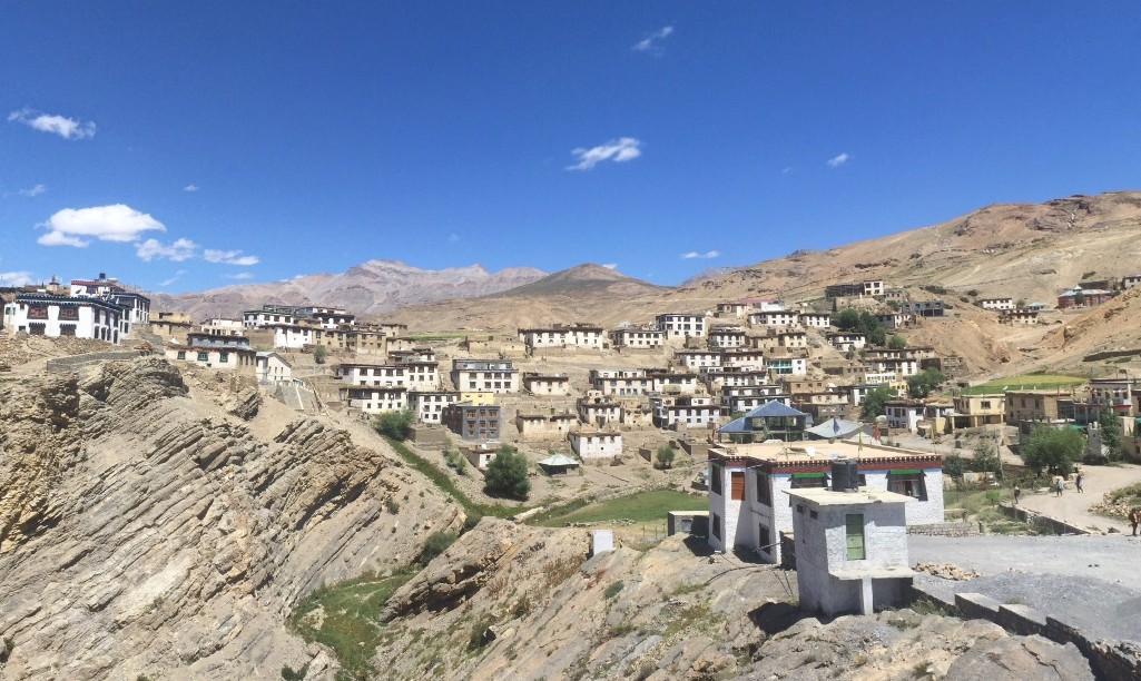
5. Komic Village (Tangyud Gompa)
- Elevation: ~4,470–4,520 m (14,665–14,830 ft).
- Monastery: Tangyud (also called Komic Monastery) at 4,520 m, built like a medieval fortress.
- Title: Often claimed as the highest village in India/world (motorable).
- Culture: Small farming community, summer grazing; deserted in winter.
Komic is one of the highest permanently inhabited villages in the world. Its Tangyud Monastery dominates the scene: a squat fortress of mud‑brick walls painted white with red trim. The monastery perches at 4,520 m on a cliff edge, overlooking Kaza 4 km away. It was founded in the Sakya tradition and dates back to medieval times (it may have roots as early as the 11th century). Locals regard it as one of the highest monasteries on earth. Below the gompa, the village of Komic spreads across a desolate plain, with just a couple dozen flat-roofed houses and rocky enclosures. In summer the residents’ yaks and goats graze above the village; everyone moves to lower valleys in winter. Travelers climb here to feel the silence of the high plateau. The stone steps are said to be sacred; pilgrims believe circumambulating the monastery brings blessings. From Komic, visitors get a clear view of the entire Spiti Valley ahead – an unforgettable panorama.
Tangyud Monastery (Komic): built like a fortress at 4,520m, with vertical white-and-red walls overlooking Spiti Valley.
6. Langza
- Elevation: ~4,420 m (14,500 ft).
- Buddha Statue: Giant golden statue of Maitreya Buddha (seated), one of Spiti’s most photographed landmarks.
- Fossils: Called the “Fossil Village”; many marine fossils (ammonites) found in the village fields.
- Atmosphere: Very small, peaceful village of a dozen families, with whitewashed stone houses and prayer flags.
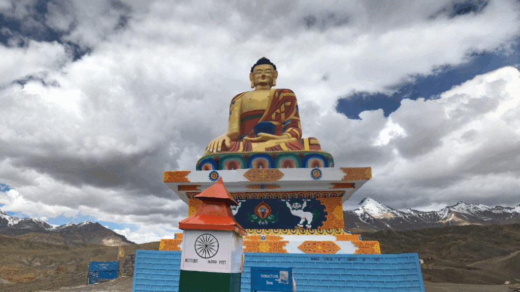
Langza is a quiet, windswept village famous for its dramatic vistas. A huge golden Buddha statue sits on a hill above the cluster of houses, gazing serenely at the mountains. The statue is nearly 15–18 feet high and honors Maitreya, the future Buddha. Despite the harsh setting, Langza’s few homesteads keep green barley patches watered by glacial streams. The surrounding plateau, once a seabed, is studded with fossils: visitors often find ammonite spirals in the soil. These 200‑million‑year‑old relics remind one that Spiti was under an ancient ocean. Langza feels timeless – children playing with prayer wheels, solar panels on roofs, and locals in traditional woolen garments. The sense is of being on holy ground amid silence. A short walk leads to a small village temple too. As one guide puts it, Langza makes you “stop and take a deeper breath” – it’s less about sightseeing and more about feeling Spiti’s ancient rhythms.
7. Dhankar Monastery & Lake
- Gompa Elevation: ~3,894 m (12,774 ft).
- Features: Perched on a 300-m cliff overlooking the confluence of Spiti and Pin rivers. Fortified “cliff‐fort” architecture, Gelugpa sect.
- History: Once the old capital of Spiti’s king; traditions date to the 12th century.
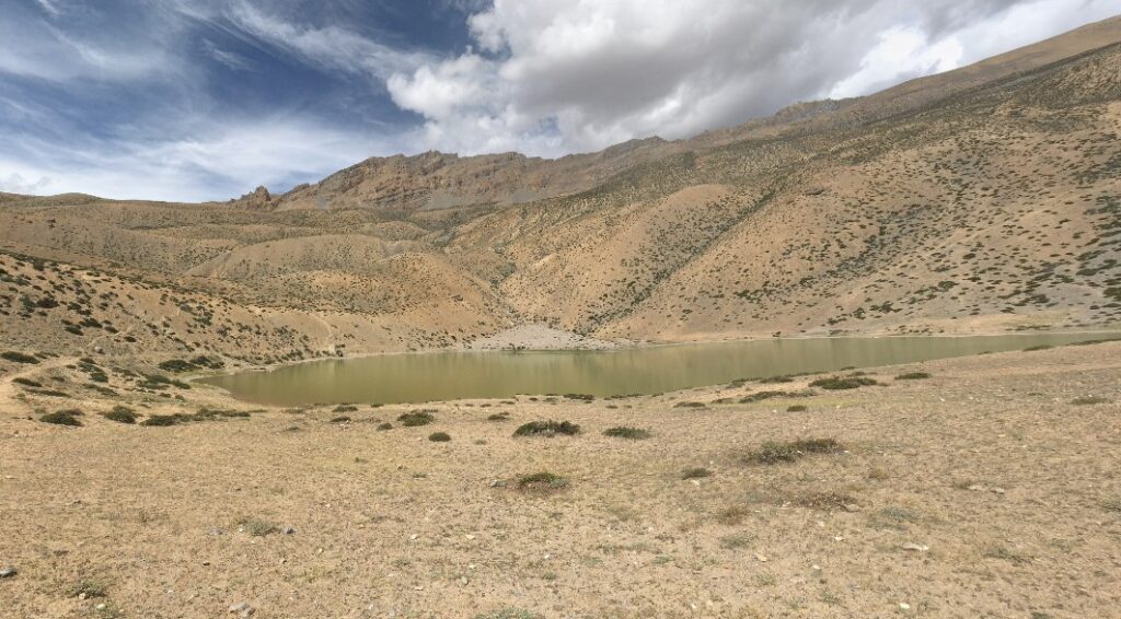
- Dhankar Lake: Glacial lake above the village at ~4,140 m; accessible by a 2–3 hour hike.
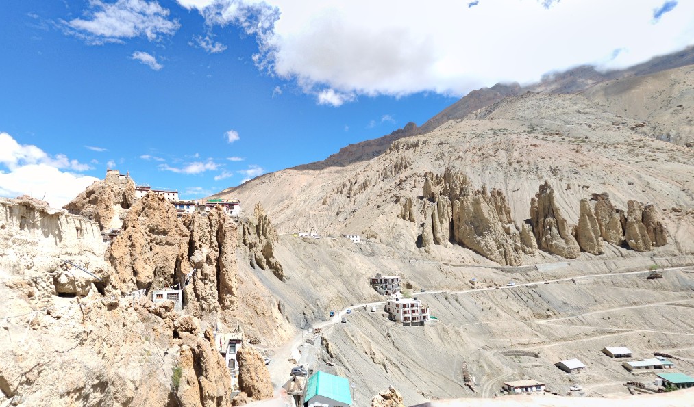
Dhankar combines both natural beauty and history. The old Gompa crowns a rocky spur 300 meters above the river junction – a dramatic setting that makes it look like a fortress on a cliff. The complex is whitewashed with red banding and includes cave shrines. The monastery was the ancient capital of Spiti’s rulers and is said to predate even Tabo Monastery. Today the Gompa has about 150 monks. A short path leads down to a newer monastery in Shichilling village below.
Beyond Dhankar town, a well-known trek climbs steeply to Dhankar Lake (also called Gumpa Tso). The lake lies at roughly 4,140 m on a ridge above the village. Its water is a clear turquoise-blue in sunlight. Camping is allowed at a site beside the lake, which is considered sacred. From the lake shore you gaze back at the monastery perched far below on its jagged ridge. The lake’s shape has been likened to a fish. Trekkers describe the views as “jaw-dropping” and the experience as very quiet – the only sounds are prayer bells and the breeze. Dhankar thus offers two highlights: the enthralling cliff-top gompa and the tranquil high-altitude lake beyond.
8. Pin Valley National Park
- Area: ~675 km² (established 1987).
- Terrain: High cold desert, elevations from ~3,500 m up to 6,000+ m.
- Wildlife: Snow leopard, Himalayan ibex, bharal (blue sheep), red fox, snow partridge, and rare alpine plants.
- Climate: Extremely cold and dry (part of the Cold Desert Biosphere Reserve).
Pin Valley National Park protects the upper Spiti-Pin drainage near the Tibetan border. It is one of India’s coldest protected areas. A bumpy gravel road (branching off past Dhankar) leads up the valley of the Pin River. The landscape is stark: sand, scree slopes and broken rock. Wildlife here is adapted to high altitude – one hopes to spot ibex on crags or even the elusive snow leopard (though sightings are rare). In spring, dholes (wild dogs) and bearded vultures also roam. The park’s highest peaks exceed 6,000 m (barely reachable by climbers). Above a certain line there is no vegetation except moss and lichens; lower down there are patches of juniper and medicinal herbs. Pin Valley passes through traditional Tibetan villages (Mud, Tinn) where nomads herd sheep and carry firewood across passes. It remains largely off the tourist track, visited by trekkers who seek wildlife and the emptiest mountain scenery. In summary, Pin Valley offers pure wilderness and rare mountain creatures, all on the boundary between Spiti and the green Bhaba Valley of Kinnaur.
9. Tabo Monastery
- Founded: 996 AD by King Yeshe-Ö of Guge.
- Significance: The oldest continuously operating Buddhist monastery in India (over 1,000 years old).
- Architecture: Complex of 9 temples, 23 chortens (stupas), and numerous caves with murals.
- Art: Called the “Ajanta of the Himalayas” for its rich frescoes and murals. Protected by Archaeological Survey of India.
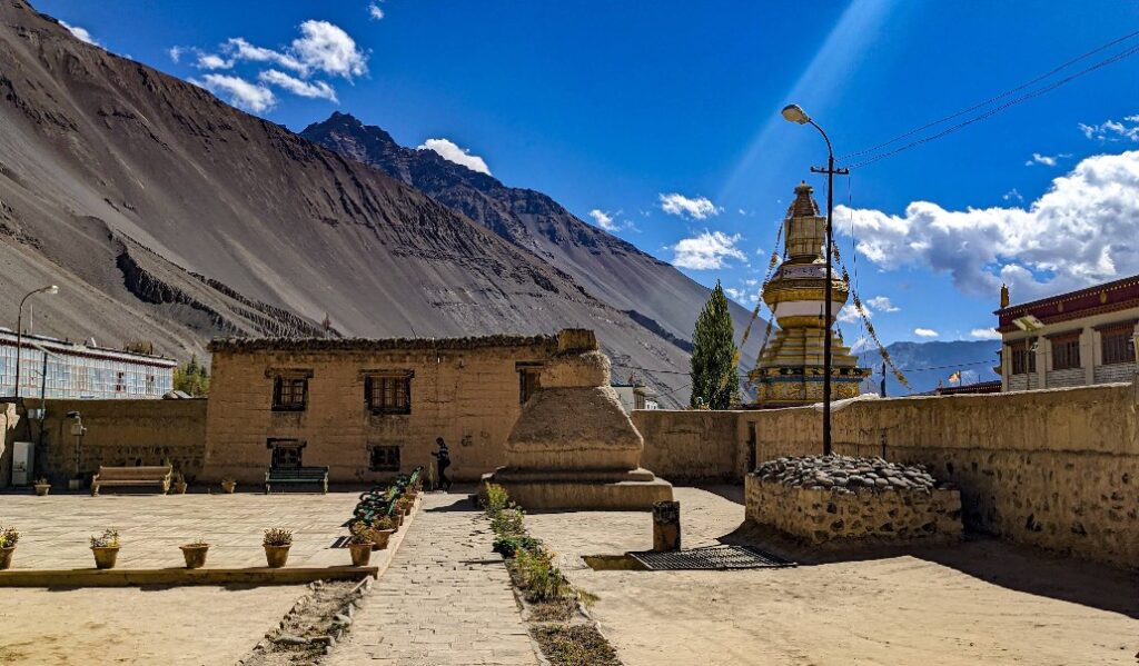
Tabo Monastery sits at the eastern end of Spiti Valley. Founded in 996 CE, it is an unparalleled time capsule of Buddhist art and culture. The monastery’s temples are built of mud and timber, painted earthy red and ochre. Every wall in the old temples is covered with vivid frescos depicting Buddha’s life and tantric deities. The artwork and statues here are said to be better preserved than any other monastery of its age. The site also includes 23 white chortens, an assembly hall, and many low-cave shrines where monks used to meditate. Tabo was once the home base for Rinchen Zangpo (the great translator) and later the site of the Dalai Lama’s Kalachakra ceremonies (1983, 1996). It is located at 3,050 m (10,010 ft) in a wide flat area. Visitors can walk through the quiet village of Tabo and climb up to view the cave paintings on the cliff. Today ASI protects Tabo as a national treasure. A visit to Tabo feels like stepping into an ancient Buddhist monastery untouched by time; it’s the valley’s spiritual crown jewel.
10. Chandratal (Moon Lake)
- Elevation: ~4,300 m (14,100 ft) above sea level.
- Shape: Crescent-shaped glacial lake (hence “Chandra”, Moon).
- Access: Reachable by road via Kunzum Pass in summer (June–Oct). Last 1 km is a hike from the parking area.
- Scenery: Deep blue waters reflecting the sky and barren peaks; considered sacred by locals.
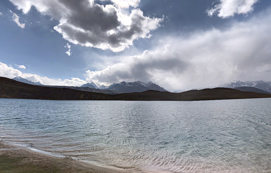
Chandratal is a jewel of high Spiti – often called the Moon Lake. It lies just beyond Kunzum Pass (4,551 m) on the road between Kaza and Manali. The lake sits in a bowl of rocks and tundra. In spring it is frozen; in summer it melts to reveal intensely blue water fringed by small tents. The thin air makes the lake’s color even more vibrant. From above one sees its curved outline, a perfectly arced crescent. There is a meager campsite at its edge where adventurous travelers stay overnight. Families of Himalayan marmots sometimes appear along the banks, and on clear nights the Milky Way arches overhead undimmed by light. Local legend connects Chandratal to the Pandavas of the Mahabharata and even a mythical mermaid who guards it. For practical visitors, it’s a long day-trip from Kaza (via Batal) or an overnight if camping is allowed. Every summer Chandratal draws photographers and trekkers who marvel at its serenity. As one writer notes, the waters “keep on changing” color through the day. In short, Chandratal is Spiti’s most famous alpine lake – high, remote, and impossibly beautiful.
Chandratal Lake at 4,300m – the crescent-shaped “Moon Lake” of Spiti. Surrounded by snowy peaks, it lies beyond Kunzum Pass and changes shades from turquoise to deep blue during the day.
Geography of Spiti Valley
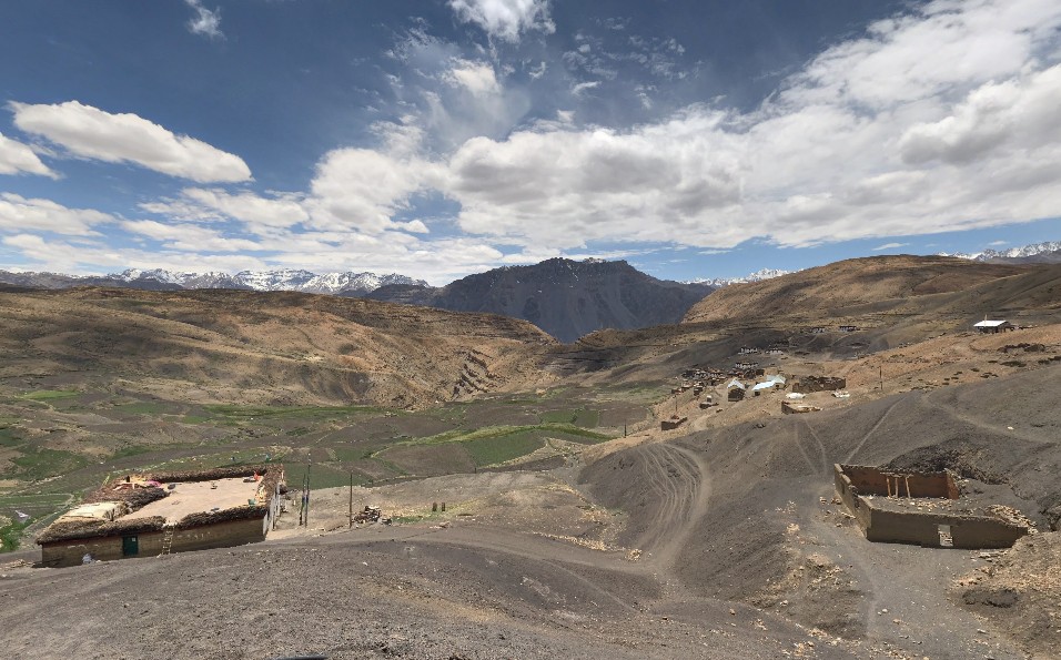
Spiti Valley occupies the upper drainage of the Spiti River, a tributary of the Sutlej. It is framed by two major mountain ranges: to the south the Greater Himalaya (with passes like Kunzum at 4,590 m) and to the north the Zanskar range. The valley itself is broad at the top (Losar area) then narrows into deep canyons. Geologically, Spiti is mostly sedimentary rock and gravel – a stark moonscape carved by glaciers and rivers. Because the main Himalaya blocklies monsoon clouds, Spiti is very arid. Annual rainfall averages only ~50 mm, and even winter snow rarely exceeds 150–200 cm. Summers (June–mid-Oct) are cold but sunny, with daytime temperatures around 15°C. Winters are very long and bitter (down to –30°C or lower) and practically shut off the valley (roads snowed-in). Most of the year Spiti’s upper reaches lie above the tree line.
The entire Spiti region covers about 7,800 km², mostly in Lahaul and Spiti district (with a little part in Kinnaur). The valley’s isolation has shaped its geography: vast open basins at 3,200–4,000 m, steep broken gorges where the river has cut through layered rock, and hanging glaciers high above. The landscape alternates between gravelly flats (used for barley fields) and towering rocky walls (home to monasteries). In spring, alpine wildflowers bloom on slopes and sparse juniper groves show flashes of green. Wildlife like blue sheep and snowcock survive on the high ridges. In short, Spiti’s geography is that of an inner Himalayan desert – a rain-shadow plateau of stone and ice with only the hardiest life.
Cultural Significance of Spiti Valley
Spiti’s culture is deeply Tibetan Buddhist. Nearly everyone here follows Tibetan Buddhist traditions. The valley was historically part of the Kingdom of Guge and later a small republic, but it has always shared culture with Tibet and Ladakh. Local languages include Bhoti (a Tibetan dialect) alongside Hindi. In villages, you’ll see mani walls, prayer flags, and chortens (stupas) at every pass or hilltop.
Villagers live a traditional high-mountain lifestyle. They grow one main crop per year (barley or peas in the short summer) and raise yaks, sheep and goats for dairy, wool and meat. Houses are made of stone and wood with flat roofs. In old times, farmers would migrate seasonally with their herds – descending to lower altitudes in winter. Today, Spiti has some modern amenities (solar power, satellite TV, roads), but daily life is still slow and communal. People bring in wood from lower valleys for heating. Local crafts like weaving and wood carving continue.
Spiti’s festivals reflect its agrarian calendar and Buddhist faith. The most famous is the Ladarcha Fair at Kaza (late August), where shepherds from all over trade livestock and goods. Losar (New Year, around Feb/Mar) is celebrated with prayers in monasteries. Other local festivals: Guitor at Key Monastery (July, masked dances), Thuckchu (mid-winter purification), Dachang and Sia Mentok (Feb). During these, villagers drink chhaang (a barley beer) and arak (local liquor) to celebrate harvest and the seasons. Buddhist ceremonies like Chham dances (mask dances) and butter lamp offerings happen at the monasteries. The spirit of all festivals is one of community – sharing food, offerings and colorful rituals against the gray mountains.
In short, visiting Spiti is not just seeing scenery but experiencing a living Tibetan culture on Indian soil. The monasteries here are not museums; they are active centers where monks chant daily. The villagers’ simple hospitality – a cup of salty tea and a prayer wheel spun for good luck – leaves a lasting impression. Travelers often return from Spiti speaking of its “pure light” and “secret wisdom” – phrases drawn from the local Buddhist outlook.
Weather and Climate
Spiti’s climate is severe. It is classified as a cold desert or alpine semi-arid climate. Winters (November–April) bring deep snow and temperatures well below freezing, often –20 to –30 °C by night. Roads over the passes (Kunzum, Rohtang) are buried in snow; most of Spiti is cut off. Spring thaws the lowest villages by late April, but higher settlements stay snow-bound until June.
Summers (June–September) are short but pleasant during the day (often 10–20 °C) with clear blue skies. Nights, however, remain chilly. Because Spiti lies in the rain shadow of the main Himalaya, the monsoon barely reaches here – annual rainfall is only tens of millimeters. Occasionally summer thunderstorms sweep through and make the rivers muddy or cause rockslides. The predictable season is autumn (Oct) with bright colors and still warm days before cold sets in. Spiti’s low humidity and high altitude mean strong sun (visitors are urged to use sunscreen and sunglasses).
One should acclimatize slowly to Spiti’s height. Even staying in Kaza (3,650 m) for a night helps avoid altitude sickness. Weather can change quickly in the mountains: sunny mornings may give way to afternoon hail or snow showers, even in summer. In winter, outside of December–February, it’s possible to drive in with special snow vehicles. In summary: pack warm layers year-round, expect dry cold, and plan the trip between late May and mid-October for road access.
Accessibility
- By Road: Spiti has no rail or air links, so road is the main entry. From Manali, the Atal Tunnel (2,000 m) and Rohtang Pass lead north to Keylong, then a steep climb over Kunzum Pass (4,590 m) into Spiti. That route is open roughly June–Oct. From Shimla (west), the smooth highway goes via Kinnaur through Reckong Peo and Rampur, then onto Kaza (about 415 km from Shimla) – this road is long and difficult but open in both summer and shoulder seasons. Distances: Kaza is ~196 km from Manali, 416 km from Shimla and ~737 km from Delhi by road. State and private buses run these routes in summer (e.g. Delhi–Kaza via Shimla, or Manali–Kaza). The roads into Spiti involve dozens of switchbacks and can be closed suddenly by landslides. Within Spiti, a single highway (NH-505) runs from Khab (Satluj River junction) through Sumdo and Kaza, then on to Kunzum Pass and lossar. Many of the side villages (like Komic, Langza, Kibber) are reached by branch roads or tracks from this main road.
- By Air: The nearest airport is Bhuntar (Kullu), about 250–260 km south of Kaza (7–8 hour drive). Bhuntar is a domestic airport with flights mainly from Delhi; road travel from Bhuntar goes via Aut and Bajaura into Puh valley. The nearest international airports are Chandigarh (roughly 480 km, ~12–14 hours) or Leh (flight to Leh + long drive). Because no airlines fly into Spiti itself, most visitors fly into Kullu or Chandigarh and then travel by road.
- By Train: There is no railhead in Spiti. The closest major railway stations are Joginder Nagar (Himachal, ~360 km from Kaza via Mandi-Kullu road), Shimla (418 km away), and Chandigarh. In practice, travelers take trains to Chandigarh, Ambala or Pathankot, then switch to buses or taxis. From Shimla station, one can hire a taxi for the long journey to Kaza; many tourists take the scenic 505 km route via Rampur–Kinnaur.
Once in Spiti, traveling between places requires a sturdy SUV or motorbike. A typical tour might be a loop: Delhi → Shimla → Kinnaur → Kaza, then back either via Kunzum/Manali or the same road. Permits: Indian citizens do not need special permits, but foreign nationals need an Inner Line Permit from the local Forest or Tourism office (as of 2025).
Final Thoughts
Spiti Valley is not a busy resort or city but a remote land of raw beauty and deep silence. From Kaza to Komic, Langza to Chandratal, every place offers peace and humility. Travel here is slow, with days spent crossing high passes or resting in quiet villages. Life is simple, cell signals may fade, yet the people’s warmth shines through. Roads open only in late spring and close by autumn, so plan wisely with warm clothes, cash, and respect for nature and local customs. More than a trip, Spiti feels like an inner journey that stays with you forever.
FAQs
Where is Spiti Valley?
Spiti Valley is in Himachal Pradesh, India, between Tibet and India, known for its high-altitude desert, monasteries, and unique culture.
How to reach Spiti Valley?
Reach by road via Shimla (all year) or Manali (summer only). Nearest airport is Bhuntar, nearest railway station is Shimla/Kalka.
How to reach Spiti Valley from Delhi?
From Delhi, buses and taxis connect via Shimla or Manali. Flights to Bhuntar or Shimla are also possible, followed by road travel.
Is Spiti Valley open in December?
In December, only the Shimla route remains open. The Manali route closes due to heavy snow, and winter travel is extremely harsh.
Is Spiti Valley dangerous?
Not dangerous but challenging. Roads are rough, weather extreme, and oxygen low. With preparation and care, it’s safe for visitors.
Is Spiti Valley open now?
Spiti stays open all year via Shimla route. Manali route remains open only May–October, depending on weather and BRO clearance.
Where to stay in Spiti Valley?
Options include guesthouses, homestays, and hotels. Kaza, Tabo, and Kibber offer good stays, with homestays giving authentic experiences.
What is Spiti Valley famous for?
It’s famous for monasteries, high-altitude villages, Chandratal Lake, fossils, unique culture, and rugged Himalayan scenery.
How many days are required to visit Spiti Valley?
Plan at least 7–10 days to cover Kaza, Tabo, Dhankar, Key Monastery, Chandratal, Langza, Hikkim, and Kibber comfortably.
What to see in Spiti Valley?
Key Monastery, Tabo Monastery, Dhankar, Chandratal Lake, Pin Valley, Hikkim (highest post office), Langza (fossils), and Kibber (snow leopards).
Which network works in Spiti Valley?
BSNL works best. Jio has limited coverage in Kaza. Airtel is patchy. Remote villages mostly depend on BSNL.
Is Spiti Valley worth it?
Yes, Spiti offers unmatched adventure, Tibetan culture, and dramatic landscapes, making it one of India’s most rewarding Himalayan destinations.
What is the last village of Spiti Valley?
Chitkul is often mistaken, but in Spiti, Losar and Gette are among the last inhabited villages near Tibet border.
When does it snow in Spiti Valley?
Snowfall usually begins in late October and lasts till March. Heavy snow blocks Manali–Kaza route; only Shimla route stays open.
Leave a Comment