Overview
Standing at the crossroads of nature’s most dramatic contrast, Hampta Pass offers what few Himalayan treks can. It gives you a journey through multiple worlds in just 4 to 5 days. It takes you to an impressive altitude of 4,290 m (14,100 ft) in just a couple of days, which is rare for most short treks in the Himalayas. Most of the trek route lies in the rain shadow of the Pir Panjal range, making it a perfect destination to visit in the monsoon since it receives minimal rainfall even during that season.
Serving as a perfect example of pass-crossing treks in India, the Hampta Pass trek is a dramatic crossover from the lush Kullu Valley to the Lahaul Valley in Spiti. On this trail, you witness both vibrant greenery and stark barren landscapes in a single journey. This rare blend of contrasts is exactly what the trek offers every trekker.
What makes Hampta Pass truly special is its easy ridge climbing. Many high-altitude climbs in the Himalayas demand extreme skills. This trek offers a moderately challenging route that welcomes both beginners and experienced trekkers. All you need is moderate fitness and good mental preparation. Most importantly, you need the will to witness something extraordinary.
When most Himalayan treks become treacherous during the monsoon, Hampta Pass thrives. Between June and September, the trail transforms into a riot of colors, vibrant wildflowers carpeting meadows, misty valleys creating ethereal atmospheres, and dramatic river crossings adding to the adventure.
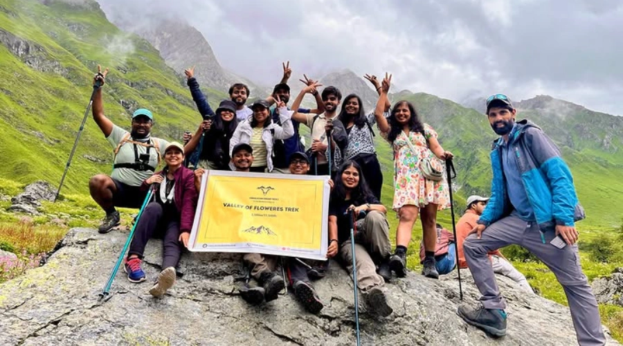
Whether you’re seeking your first Himalayan experience or adding another gem to your trekking crown, Hampta Pass delivers an all-in-one Himalayan package: diverse landscapes, challenging crossings, rich biodiversity, and cultural heritage all compressed into an unforgettable 5-day journey.
Come to witness the changing portrait of the Himalayas as you cross from one world into another.
Facts Making Hampta Pass a Must-Visit Trek
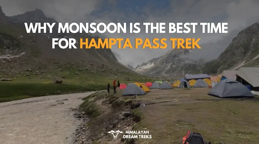
An ideal Himalayan Monsoon Trek
Most Himalayan treks shut down during the monsoon, but Hampta Pass stays open and there is a good reason for that.
The trek lies in the rain shadow of the Pir Panjal range, which blocks most of the monsoon clouds before they reach Lahaul. The Manali and Kullu Valley side of the trek does get rain, which brings green valleys, waterfalls, and cloudy mountain views. But even in July and August, the trail usually remains easy to walk on.
After crossing the pass, the landscape changes completely. The Lahaul side is much drier and receives very little rainfall.
This is what makes Hampta Pass one of the best Himalayan treks to do during the monsoon season.
Rich Topographical Diversity
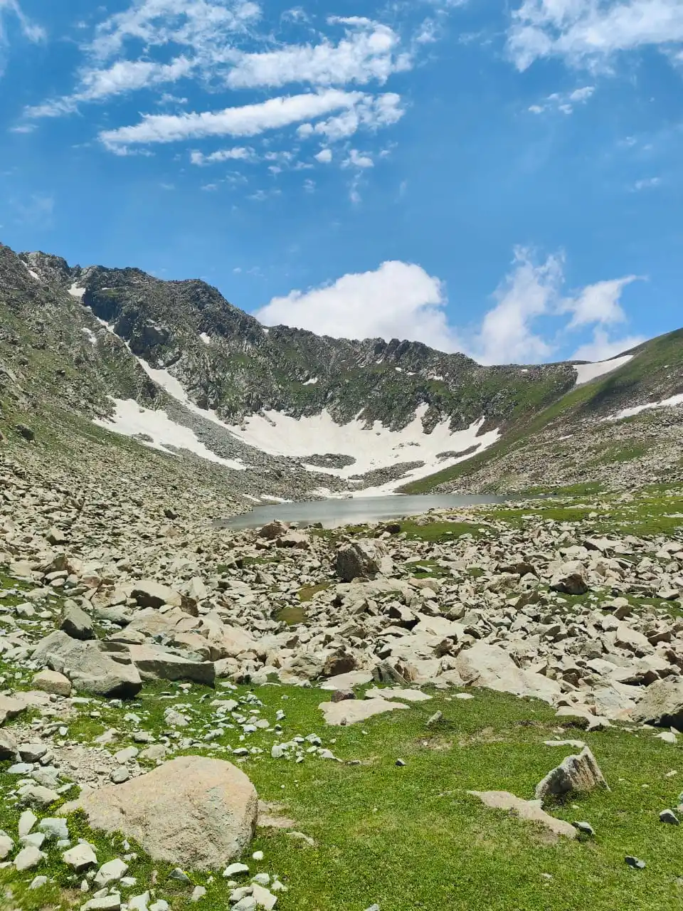
The Hampta Pass Trek offers a stunning journey through the Himalayas most diverse terrains. Starting in dense forests of oak, birch, and maple, the trail shifts to meadows, wildflowers, and glacial streams. As you ascend, greenery gives way to rocky moraines and icy rivers. Crossing the pass reveals a dramatic contrast lush Kullu Valley on one side, barren Lahaul on the other showcasing incredible natural beauty in just days.
Each campsite has a different story to tell
The Hampta Pass trek offers a dramatic shift in landscapes from Kullu’s lush green valleys and forests to Lahaul’s barren, rugged terrain. Starting at Jobra, you walk through dense woods and meadows to Jwara, where Rani Nallah flows. At Balu ka Ghera, sandy stretches appear amidst mountains. After crossing the pass, Lahaul’s rocky mountains greets you, ending at Chandra Tal—the moon lake. This trek truly show nature’s diversity.
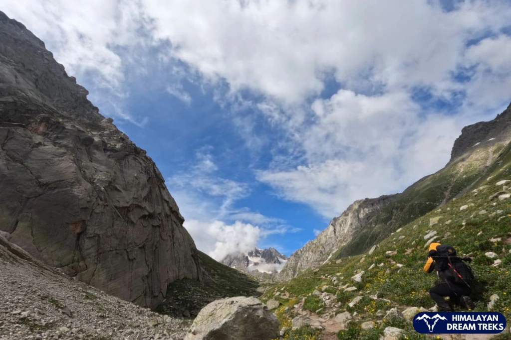
Crossing a high-altitude pass – stepping into a new landscape
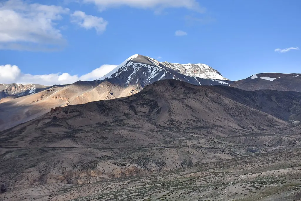
Crossing the 14,100 ft-high Hampta Pass is like stepping into a whole new world. Ideal even for beginners, this trek offers a rare chance to experience high-altitude adventure. The transition from Kullu’s lush greenery to Lahaul’s stark, barren landscape is breathtaking. Once used by traders and now by shepherds, this ancient route showcases both natural beauty and historical significance.
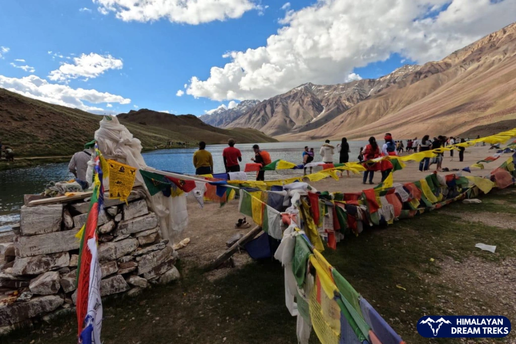
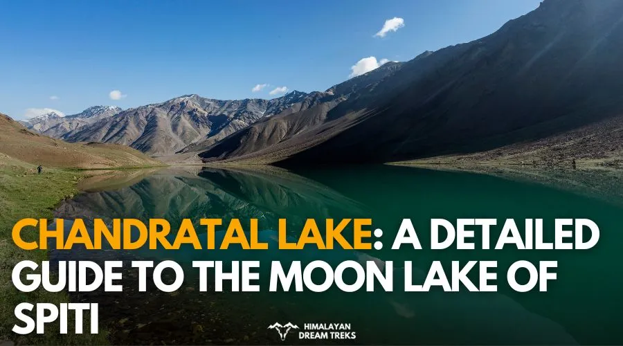
Exploration of Chandratal/ Chandra Taal
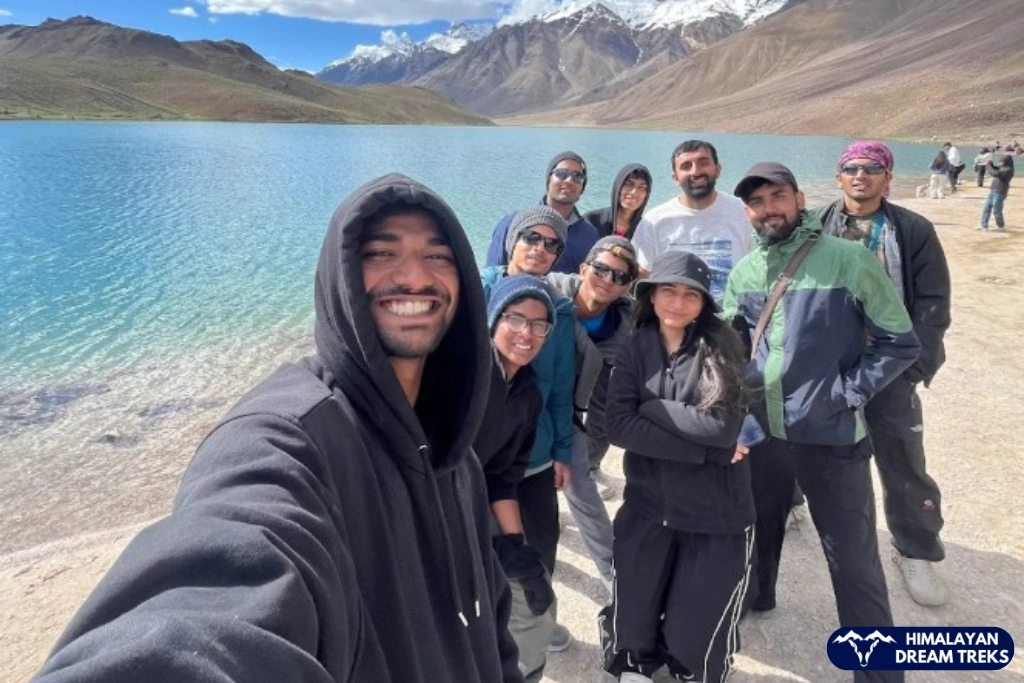
Chandratal, or “Moon Lake,” is a stunning high-altitude glacial lake at 14,100 ft, nestled on the Samudri Tapu Plateau in Spiti. Shaped like a crescent, it’s one of India’s highest Ramsar Wetland Sites. Surrounded by the majestic Chandrabhaga and Mulkila ranges, this serene lake near the Chandra River basin offers a magical end to the Hampta Pass trek.
An accessible adventure (even for beginners)
An ideal adventure for beginners, the Hampta Pass trek is one of the most accessible high-altitude experiences in the Himalayas. While it doesn’t require prior trekking experience, it does call for a fit body and a determined mindset. Spanning around 26 km over four days, the trek offers just the right mix of challenge and thrill, making it a perfect introduction to Himalayan trekking.
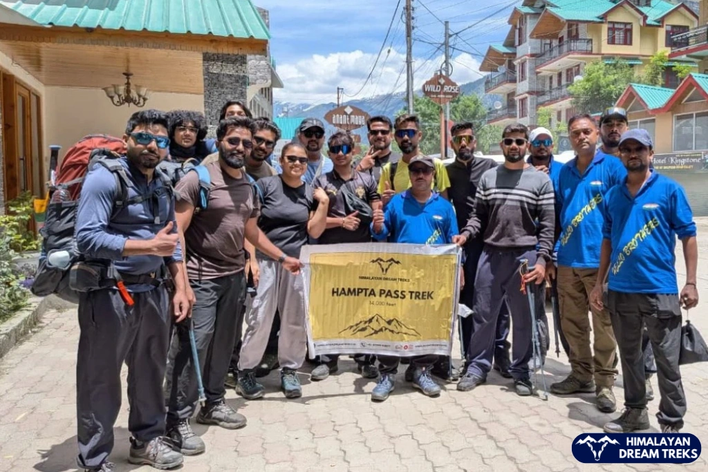
Hampta Pass Trek Itinerary [4N/5D]
Day 1: Drive from Manali to Jobra and Trek to Chika
Pick Up & Drive: From Manali 16 km drive, 1-2 hours
Trekking Distance & Duration: 3 km, 2 hours
Altitude Gain: From Manali (2,100 m / 6,400 ft) to Jobra(3,000 m / 9,800 ft): 3,400 ft/ 1,036 m ↗ | Jobra to Chika (3,100 m / 10,100 ft): 300 ft/ 91 m ↗
Difficulty Grade of The Day: Easy | Mostly flat with mild uphill
Highlight/s of the Day: Scenic drive through Manali | A short trek amidst the forest of pine, deodar, maple etc.
To begin our trek, you must first reach Manali, a famous city in the Kullu district in Land of Snow, Himachal Pradesh. Manali is known for its lush forests, snow-capped mountain peaks and ancient trade routes that cross through various passes like Rohtang and Baralacha.
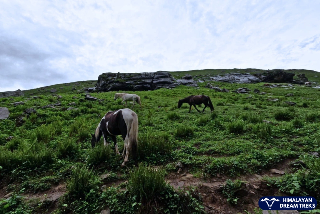
After reaching Jobra, we will start our trek marking the official beginning of our trek. The trail will be filled with tiny rocks, small streams, and tall trees of Deodar, maple, pine, etc. Once we hit the trail, it won’t take long before you come across a small shop offering eatables and other essential items. By just walking a few more metres you will be greeted by the sight of the Rani Nallah, a charming stream winding its way through a lush meadow. You will see many cattle like sheep, calves, cows grazing in these verdant meadows.
Keep walking along the left side of the stream; it will be filled with boulders and rock, but it will not be too difficult to walk on. Whereas, on the right side you will see small trees of rhododendrons and birch. While there are several routes, this is the best way to climb over a hill and descend into the vast, open expanse of meadows where Chika lies.
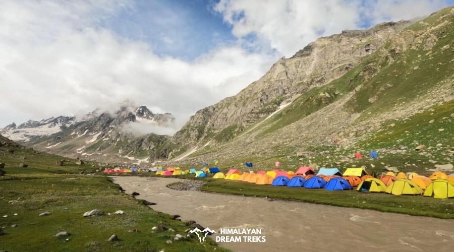
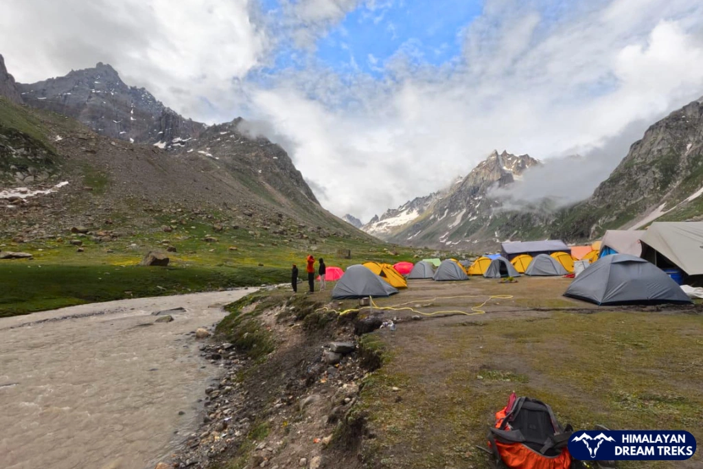
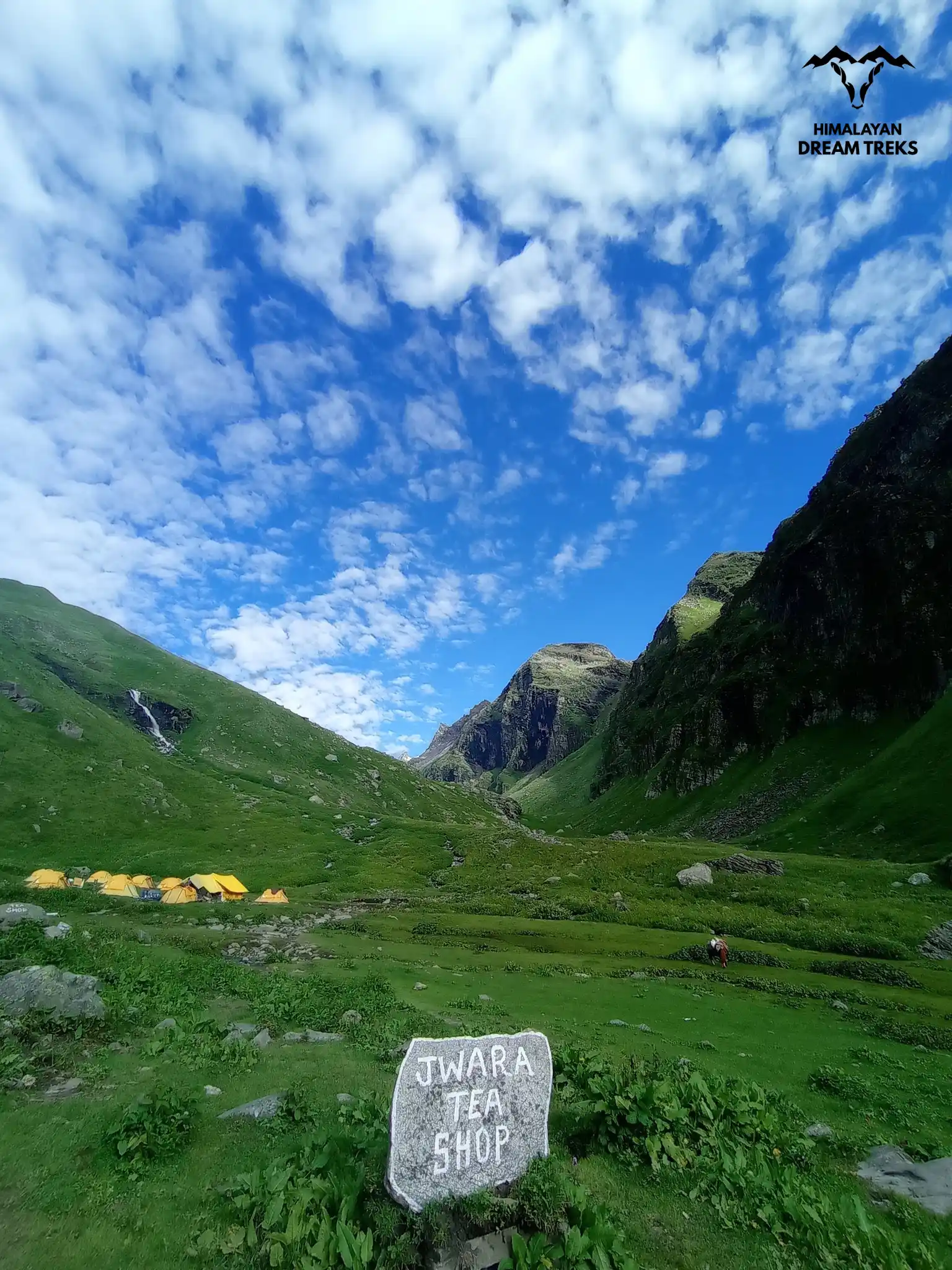
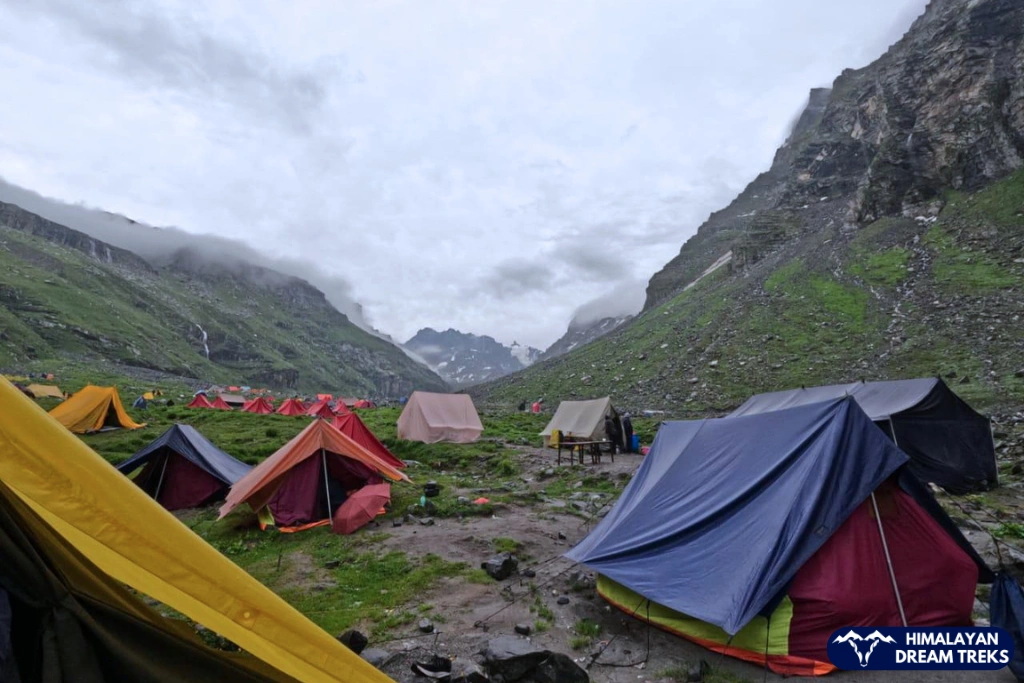
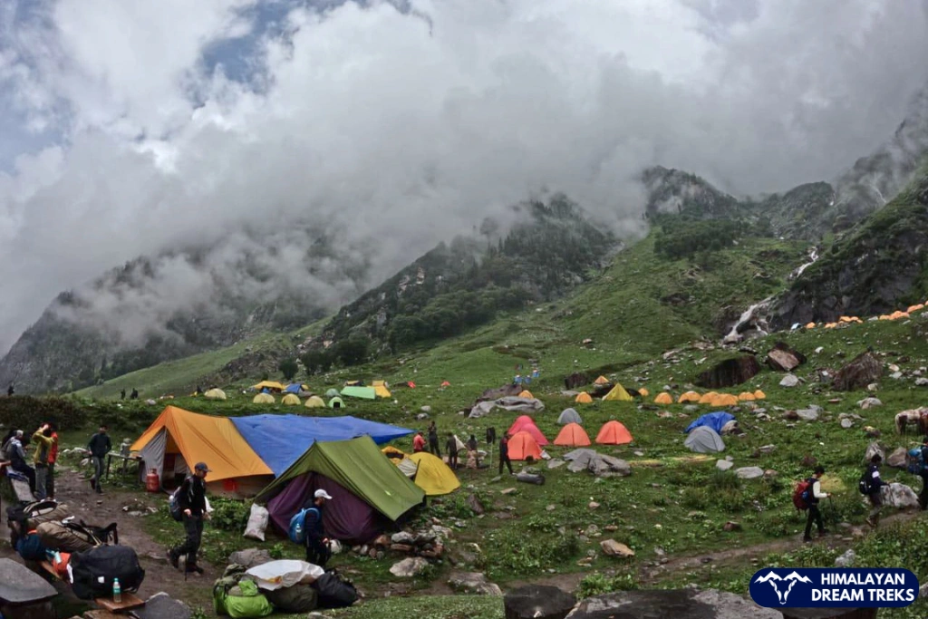
Chika is the most favourable campsite for night stay, providing a constant water source, the Rani Nallah stream encircled by the Pir Panjal mountain range.
A little far on the right of Chika campsite, you will see many waterfalls marking another campsite, Jwara. After a light snack and dinner, we will rest for the day.
Day 2: Trek from Chika to Balu ka Ghera
Trekking Distance & Duration: 9 km, 6-7 hours
Altitude Gain: Chika to Balu ka Ghera (3,800 m/ 12,400 ft): 2,300 ft/ 701m ↗
Difficulty Grade of the Day: First half – Moderate/Steep Ascent
Highlight/s of The Day: Rani Nallah river crossing
Today, we will start our trek early by having breakfast at 8 am and then start the hike. Our campsite for today, Balu ka Ghera literally translates into “Land of Sand” or “Bed of Sand.” The site is formed over the years when the river carries the debris after a landslide and deposits it here.
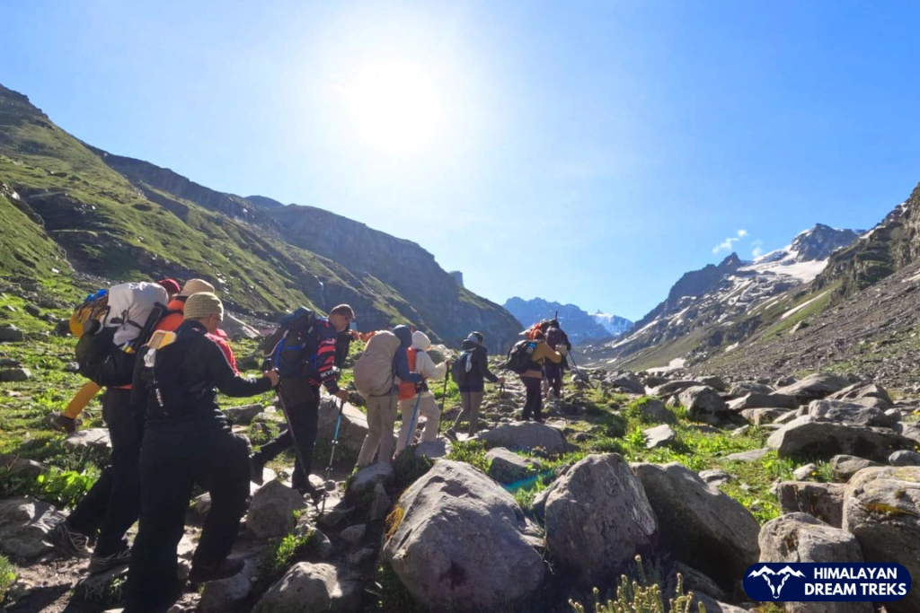
The trail today will be of rough gradient filled with big boulders that are spaced far from each other, making the jump between them difficult. Instead, we will hike cautiously while indulging in the nature as our path is also steep today.
After walking for a while, be prepared to feel the cold water of the gushing stream as you have to cross the stream of Rani Nallah stream. Our trek leader will first cross the stream to check for any danger and then you all will follow.
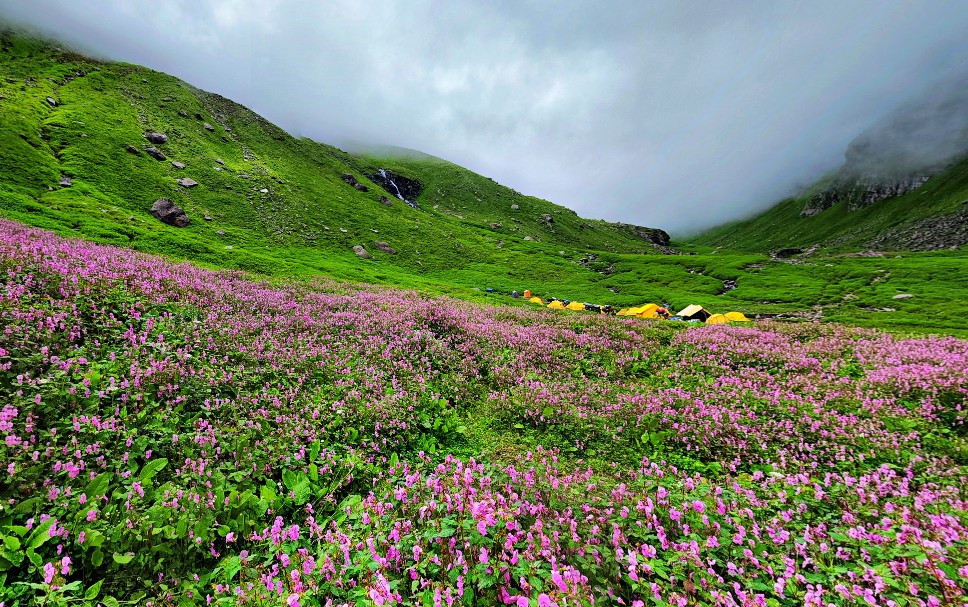
Crossing the chilling stream will refresh you and fill you up with the new enthusiasm. For some time the rough terrain will continue and after a while the flat surface of Jwara will begin. On your way you will find many colourful flowers on the trail like marigold, blue poppies, and a bunch of other cluster of flowers in red, pink, orange, etc. amidst tall snow-covered Himalayan peaks creating a postcard perfect image.
After hiking for another 3-4 km, the terrain gradient will slowly start to change into a land covered in sand and other debris, which the river carried over here and created this beautiful site, now our perfect campsite of Balu ka Ghera.
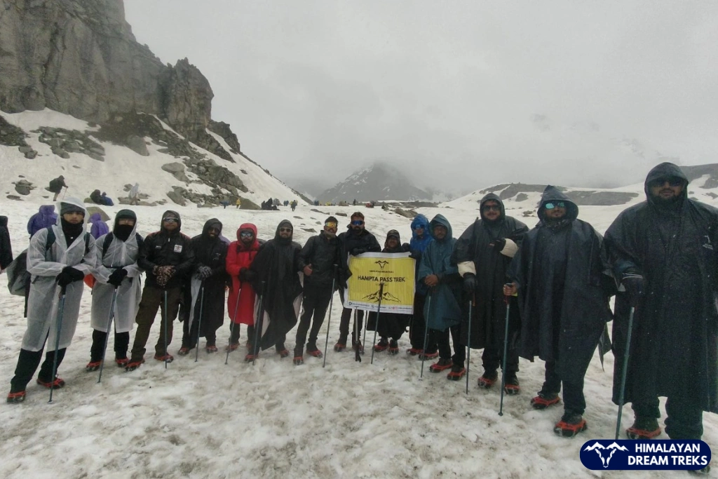
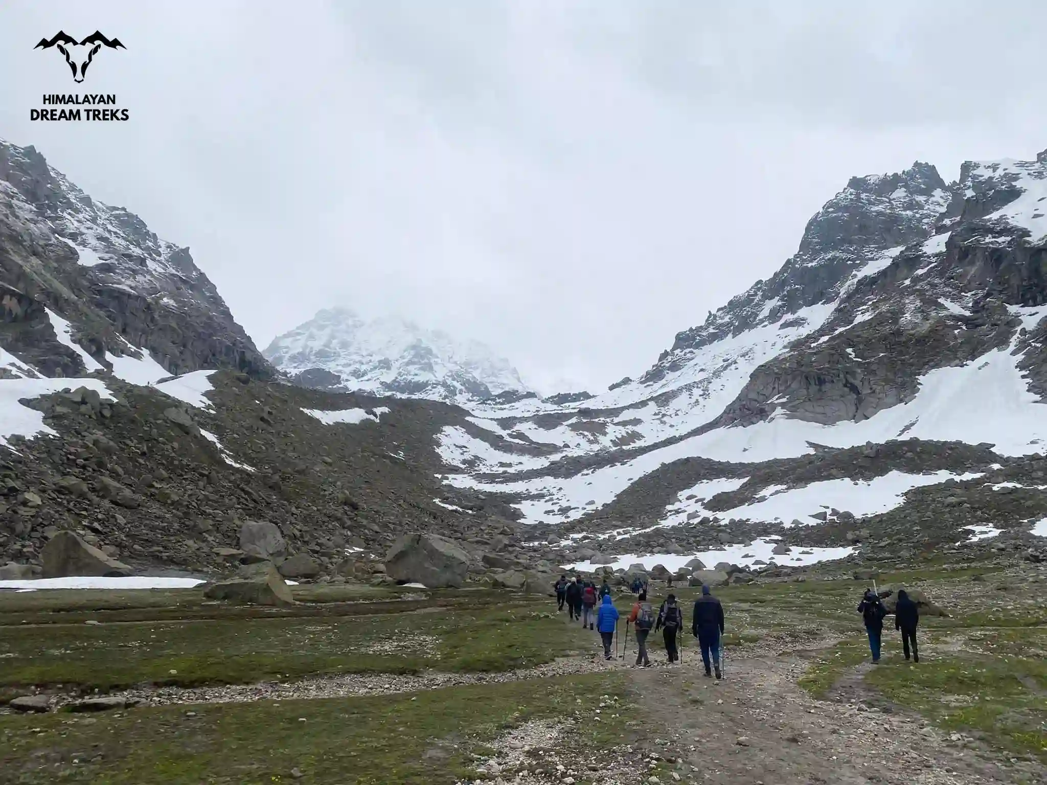
Day 3: Trek from Balu ka Ghera to Shea Goru by crossing Hampta Pass
Trekking Distance & Duration: 9 km, 8-9 hours
Altitude Gain: Balu ka Ghera to Hampta Pass (14,100 ft/ 4,300 m): 1,700 ft ↗
Altitude Loss: Hampta Pass to to Shea Goru (12,900 ft/ 3,900 m): 1,200 ft ↙
Difficulty Grade of the Day: Moderate to Difficult | The ascent of Hampta Pass is steep and the descent from there is equally challenging
Highlight/s of the Day: Rocky Terrain | Crossing the Hampta Pass | Changing terrains from vibrant meadows of Kullu to rocky & cold desert of Lahual, Spiti Valley.
Today’s trek is an exciting mix of challenges and rewards. The trek can be divided into two parts, first, you’ll tackle the hike and the mountain climb to Hampta Pass, a moderate yet steady ascent. Then comes the steep descent to Shea Goru, which requires careful footing, especially if snow’s there.
Your goal? Reach the pass by lunchtime, take a well-deserved break, soak in the views, and then start your way down to Shea Goru campsite.
We will start our day early, given our goal for today. After having a delicious breakfast, we will walk along the river. If you are trekking in summer, then you’ll be surprised by the delightful flowers varying in colours beside the riverbank, resembling the “Valley of Flowers”. For an hour you will continue on this gentle and beautiful trail.
Note: Remember to fill your water bottles here and carry at least two bottles of 1 litre each with you as the next water source in quite far from here.
But soon you will be above it and the terrain will change into a more tricky and rocky grade. The trail will not be marked well from here, so hike accordingly, and be with your group or you might get lost.
After passing a rocky section, the climb for your first incline will begin. It will take around 30 minutes to cross and then you’ll reach a plateau like space – a perfect spot to catch your breath. If you are trekking in early season, then you will witness this entire stretch blanketed in snow, giving out Narania vibes.
After the short break, the next climb awaits you. This section has two steep sections which lead you to a ridge, which will take you through Hampta Pass. The surrounding beauty and changing landscape in Hampta Valley will leave you in awe and you won’t realise when you reach the Hampta Pass.
The last stretch to Hampta Pass is a steep incline, filled with big boulders adding more challenges to your hike. But after reaching the top at an altitude of 14,100 ft your every step will feel worth the effort. Savour the moment and try to identify various peaks like Hanmuan Tibba (19,600 ft), Indrasan Peak (20,401 ft), and a few unnamed but uniquely shaped peaks like Duel Horned Peak.
Now, the tricky part—the descent. Depending on the snow conditions, you might even be able to slide down sections! Follow a zig-zag path, keeping to the right of the mountain. The first steep downhill stretch takes about 30 minutes, bringing you just below the pass. From here, you’ll either make your way down a snowy slope or follow a winding trail until you reach the valley floor in about 1.5 hours.
Now begins the tricky part of Hampta Pass – the descent into the Lahaul Valley in Spiti. Depending on snow conditions, you might just roll down the section (do not attempt this, trust us it will be painful). While descending, turn around and spot Deo Tibba (19,690 ft), just behind the Indrasan peak
Follow a zig-zag path for better footing while keeping right of the mountain. This first stretch will take about 30 minutes, covering a small section just bringing you below the pass. Descend down for another 1.5 hours following the same zig-zag method until you reach the valley.
If you’re trekking after the snow is melted, then you’ll find the path filled with big blocks of stones, boulders all the way till the final descend.
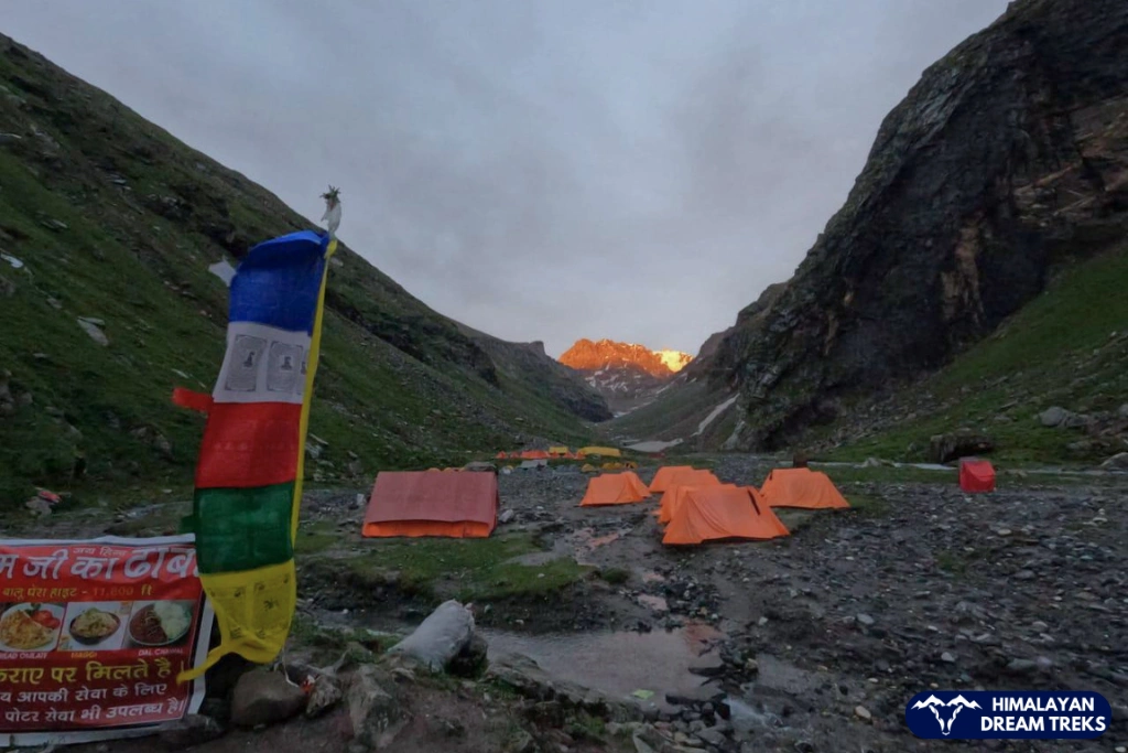
The valley will showcase a completely different terrain, showcasing the uniqueness of the Himalayan mountain ranges and terrains. The final leg of today’s hike is walking along the Chandra river to reach Shea Goru Campsite.
Today’s campsite is way more different than our previous ones with a changed rocky terrain, between the Spiti ranges, also making it our coldest campsite. After reaching the campsite of Shea Gora, take the well-deserved rest and relax under the starry night.
Day 4: Trek from Shea Goru to Chatru and Drive to Chandra Tal & Return to Chatru
Trekking Distance & Duration: 7 km, 5 hours
Drive: 50 km, 3-4 hours (one way)
Altitude Loss: Shea Goru to Chatru (3,350 m/ 11,900 ft): 1,000 ft/ 304 m↙
Altitude Gain: Chatru to Chandratal Lake (4,300 m/ 14,100 ft): 2,200 ft/ 670.5 m↗
Difficulty Grade of The Day: Easy
Highlights of the Day: Witnessing the infamous Chandra Taal, a high-altitude lake located in the Spiti Valley
Today marks another important day in our trek as we will descend down and drive to the Chandra Tal. As we have to cover the long distance of a drive twice a day, it is advised to start your day early in the morning so that you reach Chandratal in the morning itself or noon.
The downward hike today will be of easy grade of 7 kms which can easily be covered in 4-5 hours. Though due to different weather conditions, you may find some patches muddy and sloshy, so be careful while descending.
The drive will be filled with a bumpy road and coiling roads with an altitude gain. Be prepared by hydrating yourself, and if in case of AMS (Acute Mountain Sickness) take the necessary medicine like avomine.
After the drive, lay your eyes on the majestic yet graceful destinatoin- Chandra Taal. The crescent moon shaped lake lies in the watershed of the Chandra river in Lahaul Valley. Even in the rugged terrain, the lake maintains the flora and fauna nearby. You may spot fauna like blue sheep, Himalayan Ibex, Chukor, red fox, etc, and in the summer season you might spot a migratory species like Ruddy Shelduck.
After spending soaking in the beauty of the lake, we will head back to Chatru and rest for the night.
Interesting Facts:
- Chandratal was designated as a Ramsar Site in 2005. It is a list of important wetlands across the globe.
- Chaturu village marks the intersection of 3 major pass roads – Rohtang, Spiti and Hampta. Making it an extraordinary place to be at.
Day 5: Chataru to Manali Drive
Drive: 83 km, 2-3 hours
Altitude Loss: 5500 ft/ 1676m↙
Highlight/s of the Day: A picturesque drive from Chatru to Manali via Rohtang Pass
Today marks the final drive of our trek, and our journey back to Manali will pass through Rohtang Pass. We will drop you off at Manali Mall Road, leaving you with amazing memories and thrilling stories to share. The rest of the day is yours to explore the charming town of Manali, head back to your hometown, or continue your journey to the next destination in the Indian Himalayas.
Hampta Pass Trek Package
Price Inclusion
Transport from Manali to Manali is included. Pickup at 7:00 AM and drop-off at 5:00 PM. Location: Manali Bus Stand / Mall Road.
Accommodation for 4 nights in alpine tents during the trek, from Night 1 to the second-last night of the itinerary.
Meals from Day 1 lunch to Day 5 breakfast are included. The plan covers a total of 4 breakfasts, 4 lunches, 4 evening snacks, and 4 dinners — all vegetarian. Vegan, Jain, or other preferred meal options are available upon request (T&C apply).
All the required forest and camping permits
Camping gear provided: Sleeping bags, mattresses, tents, dining tent, and camping stools
First aid kit with oxygen cylinder
Certified Trek Leader and supporting staff.
Trek completion certificate and badges.
Price Exclusion
Travel Insurance (here you can get it)
Meals during the transfer
5% GST
Any items not mentioned in the inclusion
For backpack offloading, an additional fee of INR 3,000 will be charged
Any expenses arising from emergencies or personal expenses
Stay in Manali
Read more about the booking procedure, including details on payment policy, and cancellation & refund policy.
Best Time for Hampta Pass Trek
When most treks are closed during the rainy season, this trek is done during the peak monsoon season. Mid-June to early October is the best time for Hampta Pass Trek. During the time, trail is surrounded by blooming flowers, and weather conditions are mostly clear.
Trekking in June: Best for Snow Covered Landscapes
If you love snow trekking, June is the best time to visit Hampta Pass. After crossing Balu ka Ghera, the trail is covered in thick snow all the way to the pass and into Lahaul Valley. The views of endless white landscapes against deep blue skies are stunning.
Trekking in July & August: When the Valley is in Full Bloom
During July and August, the snow melts and the trail of Hampta Pass transforms into a vibrant landscape filled with colorful wildflowers. Light monsoon showers are common, but heavy rain is rare due to the valley’s high altitude and rain-shadow effect.
Trekking in September: Shade of Browns and Golden
In September, the weather at Hampta Pass becomes clearer as rains stop and skies open up. The landscape turns golden-brown with hints of lingering flowers, offering the best mountain views and stunning sunrises/sunsets.
Difficulty Level of the Route
Hampta Pass is a moderate grade trek. There are many factors that decide the grade of a trek, such as terrain, altitude gain, distance covered, number of days required, etc. There are no technical sections on this trek and can easily be triumphed by a fit person making it an ideal choice for beginners in the world of trekking. Fitness is important for this trek as the altitude gain is quick on a rough terrain with big boulders on your way. Cold glacier river crossings add more to the adventure and challenges for which you decided to embark on this trek.
Another reason is the lack of an easy exit on this trek.
Let’s analyze the deciding factors in detail that make Hampta Pass Trek a moderate level trek-
Hampta pass’s trail varies from one campsite to another, where the hike in the beginning is slightly upwards, but the soft carpet of meadows makes it easier till the Chika Campsite. Then the number of increasing boulders takes the difficulty a level up, but you will still have a refreshing vibe of the greenery around you, with a stream gushing beside you. From Balu Ka Ghera the terrain slowly transitions into a barren land, giving you a glimpse of what lies on the other side.
The trail starts to change from “Balu Ka Ghera” to the barren, cold desert of Lauhal valley resembling Leh-Ladakh’s cold desert. The amplified number of boulders, walking a ridge twice, river crossing and the final push to the pass all account. And, lastly, the climb for the Hampta Pass is here. It has steep slopes, narrow trail filled with rocks, and has hanging glaciers, so you must hike with concentration and take precaution in this challenging terrain section.
Adventure isn’t over yet, the descent, if not more than, is equally challenging as the ascent. If you are trekking in snow, then it becomes extremely difficult as you cannot see the boulders and rocks beneath you, sometimes the snow may reach up to your waist, so a hiking pole becomes necessary. Even if you are trekking in other seasons, then also the descent is rough on the big boulders, steep decline, and be vigilant here.
The path to Chhatru is easier than what you just conquered. From here, you can see the stark contrast in the vegetation. Now, the surrounding area is barren, surrounded by sharp-edged mountain peaks in cold weather with almost no greenery.
We have to drive from Chataru to reach Chandratal. After reaching the last drivable point, we hike a steep incline again, but it is all worth it for what awaits us: a crescent-shaped blue lake.
We cover approximately 28 kilometres on the Hampta Pass trek, which is also within a span of 4 days. And, the rapid altitude gain of approximately 2000 ft every day all gets added up for it to be considered a moderate level trek. Even the highest point, Hampta Pass is at a whopping 14,100 ft, which is no way less and hiking all the way in a short period of 4 days is no game.
The trek is beginner-friendly, given you are physically fit and well equipped. Mental health is also important in treks like this as the weather can change at any time. So be prepared for whatever comes your way.
Make good quality high trekking shoes your best friend, among other stuff like a right trekking bag and of course, the zeal to conquer this trek.
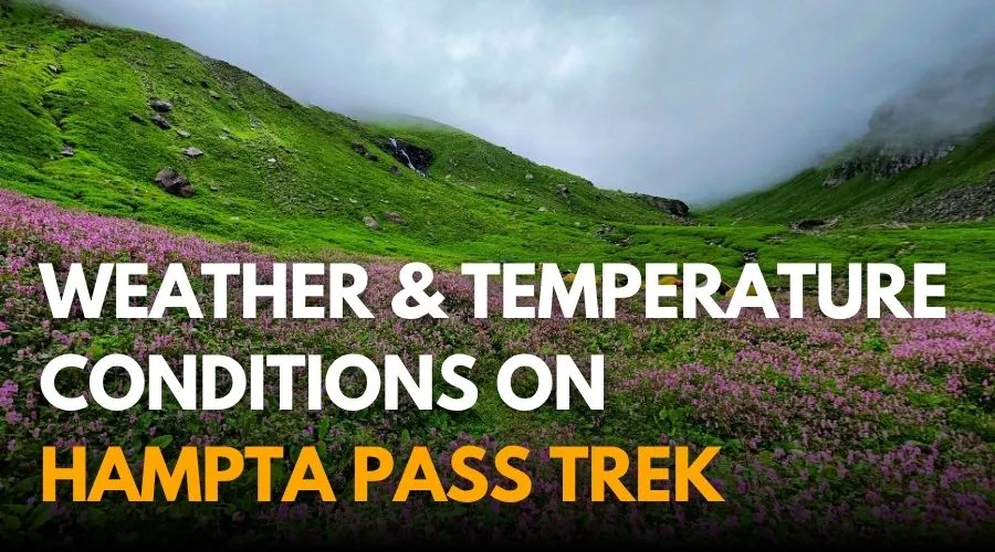
Hampta Pass is considered a cold trek even though it is done in the monsoon season. The reason for the tunnel-like structure is that you will be walking in deep valleys surrounded by the Pir Panjal ranges. The temperature remains cooler. The weather is unpredictable here, like in all the mountains. But it won’t rain heavily for days continuously, so you can trek here.
In June, the remnants of winter stay in the form of snow, but you might face some snowfall interrupting your plans, however, the chances are less, so don’t worry. September will bring colder winds, a sign of upcoming colder weather.
The temperature varies with the months you choose to do this trek (discussed in above in the best time to do the Hampta trek). But we can roughly say that June and September are colder months, whereas July and August are warmer. June marks the end of winter, while September signals its beginning. July and August brim with the freshness of the monsoon.
Preparation for the Trek
Treks are all about fun, adventure, finding yourself, etc, but only for those who are mentally and physically fit. Because activities like treks, especially a Himalayan trek, challenge you on different levels in unimaginable ways and situations.
Hampta Pass Trek falls under a moderate-level trek. Being fit is like being equipped with the right weapons for a battle. With a fit body and strong mind, you can make the most out of your trek.
The trek difficulty dictates your level of fitness and preparations for it. As mentioned above, it is moderate level trek and proper preparation is needed as it’s mountainous terrain.
- Running: Aim to run 3 km within 15 minutes over flat slope.
- Cardiovascular Training: Running, cycling, and swimming to boost stamina.
- Strength Training: Focus on leg exercises like squats, lunges, and step-ups for endurance.
- Core Strength: Planks, mountain climbers, and Russian twists to maintain balance on uneven trails.
- Flexibility Exercises: Stretching, yoga, and dynamic warm-ups to prevent injuries.
- Mental Conditioning: Visualisation techniques, breathing exercises, and meditation to strengthen focus and manage stress on difficult days.
- Exercises with Weights: For this moderate to difficult-level trek, practice exercises with weights. Seek professional advice accordingly.
- Diet: Incorporate proteins like lentils, eggs, paneer, whey protein, etc for fast recovery after a strenuous trek. Whole grains like wheat, barley, etc for sustained energy, and leafy greens like spinach, bitter guard, and any seasonal veggie for those extra nutrients and building the immunity system.
- Muscle Recovery: Plan rest days and add stretching, relaxing yoga poses or foam rolling after every workout.
- Stay hydrated: drink 2 to 3 liters of water. To incorporate more nutrients, including coconut water, fruit, and vegetable juices.
- Limit alcohol and caffeine consumption.
- Start sleeping upto 8 hours.
Altitude Sickness happens when your body cannot adjust to lower oxygen levels at higher altitudes. This happens mainly because your body doesn’t have enough time to acclimatize to a higher altitude or not enough time to get used to lower oxygen levels. Hampta Pass is situated at a high altitude location and avoiding altitude sickness preparation can make such beautiful trek into a worst experience of the Himalayas.
How to Prevent AMS?
- Gradual Ascent: Climb slowly to give your body time to adjust.
- Hydration: Drink plenty of water to prevent dehydration.
- Rest and Sleep: Ensure ample rest, especially as you reach higher camps.
- Avoid Alcohol: Limit alcohol and caffeine, which can lead to dehydration.
What to do if sickness occurs?
- Most Important – Inform your trek leader as well-trained leaders and experience they can assess the situation better and find solutions faster.
- Stop and Rest: Pause your trek to recover.
- Descend if Necessary: Descend immediately to Manali Basecamp. Our team with the vehicle and necessary help will be there for further action.
- Stay Hydrated: Drink water and avoid strenuous activity.
- Seek Medical Help: After descending, our team will take you to the nearest hospital if needed. If solo, then descend and seek the closest medical help.
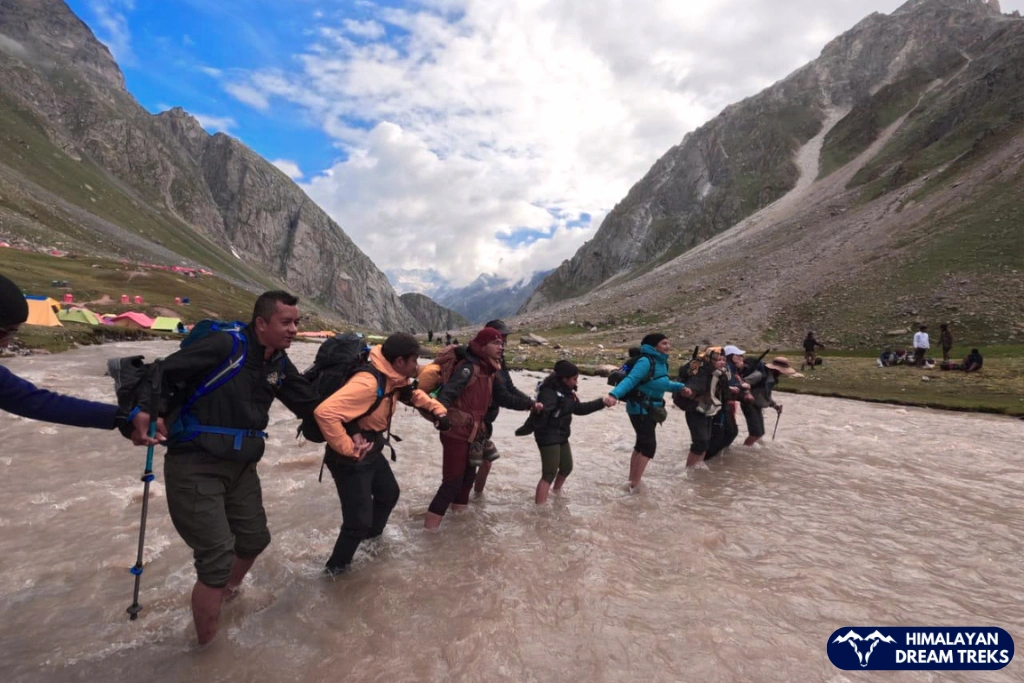
On the Hampta Pass trek you will cross the water stream twice, though they are not deep or much dangerous, still our trek leader will take the precautionary steps to make it as safe as possible.
Here are some tips which you should keep in mind while crossing –
- First, analyse the stream and select a location where the breadth is wide, the water is shallow, and the flow is slow. In a narrow strip, the water has more pressure, hence fast flowing.
- Walk on stone or nearby it, as the strong flow gets interrupted here and slows a bit.
- Do not cross the water if it reaches above your thighs.
- It is strongly advised not to hang your shoes around your neck and walk on slippery stream without socks or shoes.
- Loosen your backpack’s hip belt to make your body free and in an emergency, you can up-lift it to protect it from getting wet. Keeping your items and extra clothes dry is a precaution you must take.
- If you are in a group, then form a human chain to cross. This method helps disrupt the water flow and maintain the balance.
Pro Tip: Cross water streams wearing socks – they provide a strong grip on slippery stones.
You can find in detail about how to Safely Cross Rivers and Streams.
Trek Essentials
- 45-60 Ltr Bag Pack With Rain Cover & Comfortable Straps
- Hot and Cold Water Bottle Like Borosil and Milton
- Energy Bar, Dry Fruits, and ORS
- Personal Medical Kit
- 1 Pair of Sunglasses (UV Protected)
- 1 Neck Gaiters (Buff)
- Tiffin Box
- 2/3 Full Sleeves (Non-Cotton)
- 1 Full Fleece T-Shirt
- 1 Fleece Jacket (Woolen or Sweater)
- 1 Down Feather/ Hollofil Jacket
- 1 Waterproof Jacket/ Poncho
- 1 Pair of Thermal Inners (Upper and Lower)
- 2 Trek Pants (Avoid Shorts and Denim Pants)
- 1 Pair of Waterproof Gloves
- 1 Pair of Woolen Gloves
- Sun Cap
- Woolen Cap
- 4 Pairs of Cotton Socks
- 1 Pair of Woollen Socks
- 1 Waterproof and High Ankle Trekking Shoes
- 1 Pair of Floaters
- Hand Sanitizer and Sunscreen Lotion
- Toothbrush and Toothpaste
- Toilet Paper
- Quick Dry Towel
- Lip Balm and Antibacterial Powder
- Moisturizer
- Aadhaar Card, Pan, or Passport for Applying Permit
- Trek Insurance
- Medical Certificate
- Self-Declaration Form
- Sleeping Bag
- Common Tent
- Mattress
- Dining Tent
- Camping Stool
- Walkie Talkie (For Team)
- Utensils
How to Reach the Base Camp- Manali
The starting point of our trek is Manali, a famous tourist destination; hence, you will find many options to reach here.
Note 1: There are no direct trains to Manali, so we suggest reaching Delhi or Chandigarh first. From there, you can choose to travel by bus, hire a private taxi, or use a cab sharing if you find one.
Note 2: It is advised to reach Manali on Day 0, which is a day before the commencement of the trek. It is to prevent any delays on day 1. As you know, situations in the mountains can change at any time, because of landslides, transport delays, unpredictable weather conditions, etc.
The closest airport to Manali is known as Kullu-Manali Airport or Bhuntar Airport. The airport is 11 km away from Kullu and 52 km from Manali. From here you can hire a taxi or take a bus which plies frequently on this route.
Currently, Air India’s Alliance operates flights to Kullu-Manali Airport, but this is not a feasible option. As the price leans on the higher side, and the flights may get cancelled anytime.
To save time, you can reach other nearby cities by flight, like Delhi or Chandigarh, and then continue on a road journey.
Though we said there’s no direct train to Manali, you can reach any of the above cities by train or flight and then take a road journey. Chandigarh railway station is the best option as you will find buses for Manali that will leave from the station directly.
Manali is well-connected with motorable roads from all major cities nearby. You can reach these cities by flight or train, and then start your on-road journey.
The most suitable option is to take a government bus as they are on time and pocket-friendly, and you may use this chance to interact with locals and learn more. Besides, you can always take a private bus like Volvo.
Chandigarh is the most favorable city as you will find continuous buses leaving for Manali from both the Sector 17 Bus Stand and the ISBT Sector 43 Bus Stand.
You can book your bus tickets directly from the Himachal Road Transport Corporation website.
| Starting City | Distance to Manali (by road) |
| Delhi | 573 km via NH 3602 km via NH 344 and NH 3 |
| Ambala | 304 km via NH 3 |
| Chandigarh | 264 km via NH 205 and NH 3 |
| Shimla | 225 km via NH 3 |
| Dehradun | 430 km via NH 7 |
| Pathankot | 376 km via NH 3 |
Gangotri, the starting point for Gaumukh Tapovan, is approximately 237.1 kilometers from Dehradun. To reach there, you can hire a private taxi or take a bus from Dehradun, which takes around 7 hours.
Buses to Uttarkashi leave early in the morning from Dehradun Hill Station and Prade Ground. The bus ticket usually costs 350 – 400 Rs. And shared taxi charges from 400-500 which can be booked in Rispana Pul and Prade Ground. To reach Uttarkashi by 12 PM, you must board the bus early in the morning, around 5 am. Taxis from Uttarkashi bus stand to Gangotri leave till 2 Pm during the summer season and 12 pm in the autumn season.
Once you reach Uttarkashi, you can get a shared taxi to Gangotri, which charges 300- 400 RS and can be found at the Uttarkashi taxi stand.
We also arrange transportation services for our trekkers, with the pickup point being Prince Chowk, Dehradun and pick-up time between 6 am and 7 am. An add-on of INR 2500 will be charged from trekkers.
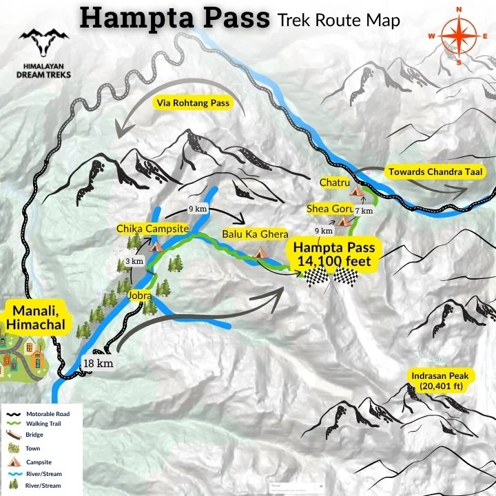
Hampta Pass Trek Map
The route map of Hampta Pass Trek usually follows these steps: Manali → Jobra → Chika → Balu ka Ghera → Hampta Pass → Shea Goru → Chatru → Chandra Tal → Back to Chatru → Manali.
Today’s Weather & Temperature at Manali Base
Additional Info About Hampta Pass
Hampta Pass is undoubtedly one of the most picturesque treks, and it also has deep cultural and historical significance. In earlier days, Hampta Pass was used as a trade route between Lahaul and Kullu, allowing local shepherds, and traders to move around.
In the present time, as well, you’ll see local shepherds also known as Gaddi Shepherds, a semi-nomadic herders’ tribe, taking their cattle in these fields for grazing. On the trail, you’ll have the chance to interact with local shepherds, offering a unique perspective on the valley and the lifestyle of the people living there.
This centuries-old passage played a crucial role connecting these distinct lands and their people. You will see the reflection of Himachali traditions and Tibetan influences in the nearby areas, such as villages, architecture, and monasteries.
The trek ends in Chandratal, a place that holds spiritual significance for both Hindu and Buddhist religions. It is believed that the eldest Pandava Yudhisthir went to heaven from this place in the chariot of God Indra.
Exploring Hampta Pass is not just a physical journey but also a glimpse into the region’s rich heritage and timeless traditions.
Hampta Pass is often called the Valley of Flowers of Himachal Pradesh, and for good reason. The region is home to a remarkable variety of flora and fauna, including hundreds of plant species, diverse mammalian life, and a rich birdlife that draws naturalists from across the country. Below is a curated list of some notable vegetation, vibrant wildflowers, and medicinal plants you may encounter on the trail.
Flora
Here’s a table on not just vibrant flora, and diverse vegetation but also medicinal plants you will see on the Hampta Pass Trek.
| Scientific Name | Common Name | Type/ Form | Uses |
| Abies Pindrow | Western Himalayan Fir | Tree | Timber/ resin extraction |
| Acer Acuminatum | Maple | Tree | Wood, fodder, fuel |
| Betual Utilis | Himalayan Birch (Silver Bark) | Tree | Earlier used for writing manuscripts, medicinal use |
| Prunus Cornuta | Himalayan Cherry | Tree/ Blue-black fruits/ white flowers | Bluish fruit, medicinal |
| Quercus Semecarpifolia | Brown Oak | Tree | Timber, fodder |
| Salix Denticulata | Willow | Tree | Basket making |
| Clematis Montata | Himalayan Clematis | Climber | Ornamental, Medicinal |
| Juniperus Communis | Black Juniper | Shrub | Medicinal, flavouring in food and beverages, fragrance in soap and cosmetics |
| Lonicera Parviflora | Honeysuckle | Shrub | Red ornamental plant |
| Rosa macrophylla | Big leaf rose | Shrub/Flower | Cures skin diseases, ornamental, tea substitute |
| Angelica Archangelica | Wild celery | Shrub/Flower | Sweet scented edible stems and roots |
| Adiantum venustum | Evergreen maidenhair fern, aka “Hansraj” | Shrub/flower | Treating cough, cold, fever and headache |
| Bistorta Affinis | Himalayan fleeceflower, Himalayan knotweed | Perennial plant/ deep pink flowers | Treating diarrhea, cold and fever |
| Anaphalis Contorta | Eared-leaf Pearly Everlasting/ Everlasting flowers | White flower plant | Treating cuts, wounds, boils, even works as an insect repellent |
| Taxus wallichiana | Himalayan Yew/ Thuner | Medicinal Plant | Anti-Cancer (Breast and ovarian) |
Fauna (Wildlife)
Apart from a wide range of flora you’ll find a variety of fauna here, but the chances of encountering wildlife are low. The animals love their peace and stay away from the hustle of humans, but if you are lucky enough to encounter one, please maintain the distance and do not try to catch them.
The wildlife you may come across are – Snow Leopard, Himalayan brown bear, Himalayan tahr, musk deer, Himalayan monal, western tragopan (state bird of Himachal Pradesh), cheer pheasant, eagles, vultures, Himalayan Bulbul, whistling thrush, etc.
While on this adventure, you can explore other beautiful destinations such as-
- Bhrigu Lake Trek
- Kareri Lake trek
- Solang Valley
- Parashar Lake
- Kasol
- Beas Kund Trek
SCL, Foreign Permit & Vehicle
Himalayan Dream Treks is registered with the IMF, and we can cater to the needs of SCL for Government Employees. According to the rule, the government of India provides its employees with a prospect where they’re allowed to apply for a 30-day special casual leave in a calendar year to do trekking, hiking, or whatever adventure pleases them.
Mail us at info@himalayandreamtreks.in or call us at +91 80896 93825, if you want to avail SCL.
For foreign nationals, permit charges are different, and hence the overall package price is different for foreign trekkers. Connect with us before booking your trek.
- For 4-6 people Ertiga/Bolero or equivalent vehicle.
- For 7 or more people, Force Traveller.
FAQs
The total distance is 28 km. The entire circuit takes around 4 to 5 days to complete. The first day covers 3 km; the second and third days cover 9 km each, and the fourth day involves 7 km of trekking. The fifth day is a visit to Chandratal Lake, which is a road trip of about 50 km one way.
No, Travel insurance is not mandatory for this trek but recommended for liability and safety purposes. You can get your insurance from ASC360.
Yes, you can do the Hampta Pass Trek solo only if the route starts and ends at Jobra without visiting Chandratal Lake or Rohtang Pass. Most people, especially solo travelers, join group treks run by experienced companies like Himalayan Dream Treks (HDT). These treks take care of your basics: food, water, tents, and everything in between. You’ll find yourself walking beside strangers who quickly become friends. The vibe is warm, the crowd is often solo like you.
Yes, every campsite is equipped with dry pit toilets. But you must carry your own toilet paper for your convenience.
Manali has ATMs where you can withdraw cash.
Charging your devices can be a bit difficult during the trek. For the Hampta Pass Trek, the final place where you can charge your gadgets is in Manali. So, it’s better to carry extra batteries for your camera and a power bank with over 20,000 mAh capacity to make sure you have enough charge for the whole trek. Power bank and other trekking gear on rent is an affordable option you choose.
The Hampta Pass Trek reaches a height of 14,100 feet above sea level, where altitude sickness can be a common issue. It’s important to climb slowly, drink plenty of water, and be aware of signs like headache, feeling sick, or dizziness.
We serve pure vegetarian meals throughout the trek, offering wholesome dishes like rice, dal, roti, seasonal vegetables, parathas, and more freshly prepared to keep you energized. The package includes 4 breakfasts, 4 lunches, 4 evening snacks, and 4 dinners, starting with lunch on Day 1 and ending with breakfast on the final day of the itinerary.
If you follow a Jain diet or have any specific dietary requirements, please inform us in advance, and we will do our best to accommodate your needs.
Note: Only vegetarian meals will be provided throughout the trek.
Network is available during the trek through providers like Jio, Airtel, and BSNL. After the Chika campsite, there is no mobile network. Our team will use walkie-talkies to stay in touch.
Our package of Hampta Pass Trek includes overnight stays in spacious, comfortable tents under the starry sky. We set up camp at breathtaking scenic locations, ensuring cosy camp stays and a truly memorable trekking experience. Accommodation is in tents on a triple-sharing basis, with all required equipment for camping provided, including foam sleeping bags, foam mats (sleeping mats), and sturdy 3-man tents. Air mattresses and inner liners are available at additional costs for extra comfort. If you prefer single or double occupancy, extra charges will apply — INR 6,000 for single occupancy and INR 4,000 per person for double occupancy (for couples or friends). This setup ensures a comfortable, cosy and enjoyable camp stay for a memorable trekking experience.
To secure your spot with us, an initial booking amount is required, based on the type of trek you choose. Hampta Pass falls under the category of longer treks (4–15 days) and for such trekking duration, the booking amount is 30%, with the rest payable 15 days before the trek begins. Customized packages of Hampta Pass Trek will require a 50% advance, also to be cleared 15 days prior. Please note, trek vouchers—according to our cancellation policy—are only issued once full payment is done. Additionally, 30% advance payments are non-refundable and not eligible for vouchers. For more detail on payment policy, cancellation and refund policy, you can checkout our website.
If you’re new to trekking, Hampta Pass is the smarter pick. A genuinely stunning 4-day trek that starts from Jobra in Manali and ends in Chhatru village. It’s beginner-friendly yet thrilling lush green Kullu valleys, ridge climbs, and a dramatic Spiti or Lahaul Valley crossover. Sar Pass is beautiful too, starting from Kasol and ending in the Parvati Valley of Himachal Pradesh. But Sar Pass has steeper ascents and snow sections that can be tricky for first-timers. While both offer stunning views, Hampta strikes the perfect balance of ease and adventure.
It’s a monsoon trek, open from mid-June and continuing through the monsoon season. It usually closes by the end of September or mid-October.
On this medium difficulty trek, you need to carry basic camping gear along with healthy snacks. Things you need: good trekking shoes, a rucksack with a rain cover, sun cap, sunscreen, one pair of warmers, a fleece jacket, and a solid hardshell jacket for chilly nights. Don’t forget a poncho or raincoat, a fresh pair of socks for each day, power bank, toilet paper, and sanitizer—all essentials that’ll keep you dry, warm, and sane on the trail.
Things you can rent: trekking poles and a headtorch—super useful, but no need to buy if you’re not a regular trekker. These items can also be rented from us, but make sure to check the availability of rental gear before starting the trek.
Also, give us a quick call to check if it’s raining. If it is, pack an extra set of clothes and a polybag for wet ones.
Yes, you do need a permit for the Hampta Pass trek.
A lot of people assume that there’s no permit needed because there’s no forest check post at Jobra, the starting point. But officially, the trail passes through Inderkilla National Park, which is a protected area. That means a forest entry permit is required, and you’ll have to get it from the Forest Department office in Manali. It’s an offline process and usually doesn’t take too long, but it’s better to get it sorted a day before you begin your trek.
If you’ve booked your trek through a company like us, we’ll handle the permit for you. But if you’re going on your own or with friends without a guide, make sure you visit the forest office and get the permit yourself. It’s important not just from a legal point of view but also for safety tracking.
Also, the trek route includes Chatru or a visit to Chandratal Lake, and for that, you’ll need a separate vehicle permit to cross Rohtang Pass on the return. To apply online permit for the Pass visit the official web portal of department. Chandratal, being a protected wetland, has its own small entry fee too. Both of these are usually included in full trek packages provided by us.
In short, yes, you’ll need a permit for the Hampta Pass trek whether you’re doing a round trip from Jobra or completing the full route that ends near Chandratal. If you’re taking the full route, you’ll also need two extra permits: one for crossing Rohtang Pass and another for visiting Chandratal Lake.
Yes, Hampta Pass Trek is suitable for beginners, provided you have moderate fitness and no serious medical conditions. The trail covers 28 km over 4 days with a gradual difficulty progression, giving your body enough time to acclimatize.
The altitude of Hampta Pass is 14,100 ft (4,300 m) above sea level. This makes it one of the highest crossover passes accessible to beginner and intermediate trekkers in the Himalayas. At this height, you can witness a dramatic landscape shift from the lush green Kullu Valley on one side to the stark barren cold desert of Lahaul Valley on the other.
Hampta Pass Trek requires 5 days and 4 nights – starting and ending at Manali. The route covers 28 km over 4 trekking days, with Day 5 being a drive back from Chatru to Manali via Rohtang Pass. This duration also includes a visit to the stunning Chandratal Lake at 14,100 ft on Day 4, making it a complete Himalayan experience within a short timeframe.


Leave a Comment