Ali & Bedni Bugyal are among Asia’s largest meadows. Situated in the Chamoli district of Uttarakhand, these meadows range in elevation from 11,000 ft to 12,550 ft. Whether you’re seeking adventure treks in Uttarakhand, spiritual pilgrimage vibes, or simply a peaceful place to unwind, the Ali Bedni Bugyal trek offers it all. It provides beautiful views of some of the Himalayan peaks, such as Trishul, Nanda Ghunti, Mrigthuni and Chaukhamba. Vast meadows at a high altitude and cool climate are sure to offer a refreshing escape from the hustle and bustle of city life.
The trail has a spiritual and religious significance of its own. The world-famous Nanda Devi Raj Jat Yatra, which is held every 12 years, is also referred to as the Himalayan Kumbh. This yatra passes through the meadows of Bedni, making it a must-explore option for pilgrims in India.
How to reach India’s largest and highest-altitude meadows, Ali & Bedni Bugyal?
To reach Bedni Bugyal, here is a step-by-step guide for everyone.
Facts that you should know before travelling to Ali and Bedni Bugyal in Uttarakhand-
- Basecamp of Trek, Lohajung: To reach these meadows, start your journey from Lohajung, as it is the easiest route due to its comparatively gradual ascent and good camping options along the way. The distance from Lohajung to Bedni Bugyal is about 20 km. The trek can also commence from Wan village, which is approximately 11 km but involves a steep ascent.
- Nearest Airport: Jolly Grant Airport of Dehradun, which is only 15 km from Rishikesh.
- Nearest Railway Station: Yog Nagri Railway Station, Rishikesh (YNRK).
- Nearest Bus Station: Rishikesh Bus Stand, which is situated in Adarsh Gram.
After reaching the nearest airport, bus station, or railway station in Rishikesh, it’s time to find the best route to Lohajung, the base for the Ali Bedni Bugyal trek. Below are the most efficient travel routes.

Routes to Reach Starting Point of the Trek, Lohajung
Route 1: Rishikesh to Lohajung via Karanprayag
Step 1: Take a bus from Rishikesh Bus Stand towards Joshimath/Badrinath and purchase a ticket for Karanprayag. This journey takes approximately 6-7 hours, covering 170 km. The buses start early, so it’s best to catch one around 6:00 AM to reach Karanprayag by afternoon. Along the way, you will pass through Devprayag, Srinagar, and Rudraprayag, all of which offer beautiful views of the Ganga and Alaknanda rivers.
Step 2: From Karanprayag Bus Stand, take a shared jeep to Tharali (47 km). This drive takes around 1.5 to 2 hours and follows the scenic Pindar River, offering beautiful views of lush green valleys and small hillside villages. If you have time, you can stop at Nandprayag, another beautiful confluence of rivers, just a few kilometers ahead.
Step 3: From Tharali, take another shared taxi heading towards Deval (14 km). This journey is relatively short, taking around 30-40 minutes, but the road is slightly narrower. Deval is a small junction, as it serves as the last major market area before Lohajung. If you need any last-minute supplies for the trek, Deval is a good place to stock up.
Step 4: Once you reach Deval, you can find a shared taxi or arrange private transport for the final leg to Lohajung. The route from Deval to Lohajung offers views of Nanda Ghunti and Trishul peaks on clear days. This drive takes about an hour, with winding roads that gradually ascend towards Lohajung.
Route 2: Kathgodam/Haldwani to Lohajung via Baijnath
Step 1: From Kathgodam or Haldwani, take a cab or bus to Almora. The journey from Kathgodam to Almora covers 90 km and takes around 3-4 hours, offering beautiful views of the Kosi River and surrounding pine forests. Almora is a beautiful hill town, known for its colonial-era architecture, bustling bazaars, and the famous Bright End Corner viewpoint.
Step 2: From Almora, travel via Baijnath to Gwaldam, where you will find shared cabs heading towards Deval. Baijnath is home to the Baijnath Temple, a 12th-century temple dedicated to Lord Shiva. From Baijnath, the road leads to Gwaldam, a lesser-explored yet beautiful town with breathtaking views of Nanda Devi and Trishul peaks.
Step 3: From Deval, take a shared taxi or hire a private vehicle to reach Lohajung.
This route is an excellent option for travelers coming from the Kumaon region, offering a different yet equally beautiful landscape compared to the Garhwal route.
After a successful journey of reaching Lohajung, it’s time to be well prepared for the walk to Ali & Bedni Bugyal.
Trekking Route to Reach Ali & Bedni Bugyal
Step 1 – Lohajung to Didna Village
This trek will start at Lohajung at 2,350 m and follows a descent path towards Raun Bagad, a scenic riverside point. This path is about 3 km downhill, so trekking poles are useful here.
During the trek, you cross a wooden bridge over the river Neel Ganga. The water is clear and okay to refill your water bottles here.
From Raun Bagad, a climb starts off about 2-3 hours till Didna Village. In this ascent section, you come across oak and rhododendron forests. After reaching Didna, you can experience the local food prepared by homestays. You will also feel a vibe when you see locals returning from their farming and cattle rearing in the evening.
Step 2 – Didna Village to Ali Bugyal
It is a steep, continuous trail of 10 km, which takes approximately 5-6 hours to complete. You come across a small hamlet, Tolpani, where shepherds of the Garhwal Himalayas stay during summer.
After crossing the forest of oak, birch, and rhododendron, you step onto one of the most beautiful high-altitude meadows in India, Ali Bugyal. This bugyal is a little bit smaller compared to Bedni, but the beauty is superb.
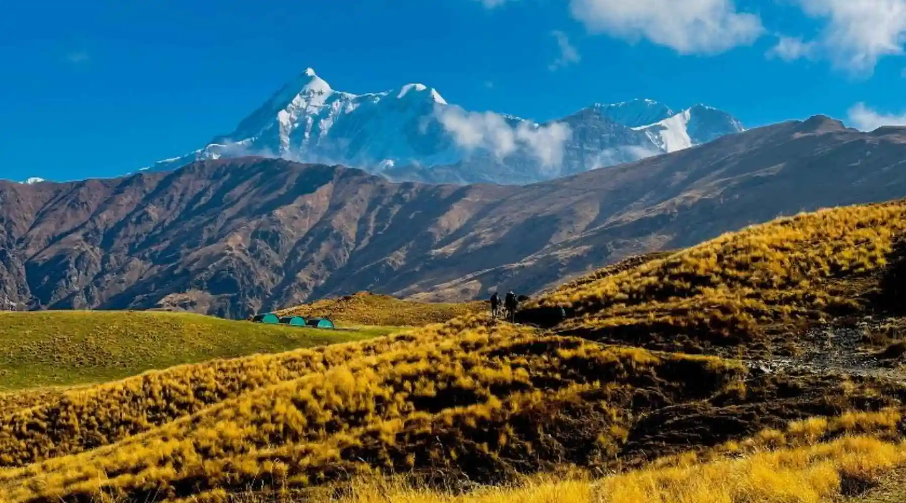
From Ali Bugyal, you get clear views of Trishul, Nanda Ghunti, and Chaukhamba peaks. It’s a great opportunity for photography, especially at the moments of sunset and sunrise.
Step 3 – Ali Bugyal to Bedni Bugyal and back to Ali Bugyal
This is the easiest leg of the entire route compared to other days. The trail is mostly gradual, and you see a few ascents and descents.
After about 2-3 hours, you will reach Bedni Bugyal, which is at an impressive altitude of 12,550 ft. You get a close-up view of Trishul and the famous Bedni Kund here, which is a small but sacred alpine lake.
Also, don’t miss a small Nanda Devi Temple, which has a prominent spot for pilgrims, especially during the Nanda Devi Raj Jat Yatra.
At a distance of about 12 km from Bedni Bugyal, there is the mysterious lake of Roopkund, also known as Skeleton Lake. However, visiting this lake may not be feasible as it requires strong physical fitness to cover almost 25 km in a single day. In 2018, the Uttarakhand High Court issued a ban on overnight camping in high-altitude meadows, meaning you cannot pitch your tents beyond Ali Bugyal.
Step 4 – Get Back to Lohajung directly from Ali Bugyal
To get back to Lohajung, it’s a different route than the one you followed to reach Ali Bugyal. You descend towards Gahroli Patal, which is a forest camping site. The trail proceeds continuously downhill towards Wan Village. This is the largest village in this region, which is well known for the ancient Latu Devta Temple.
After proceeding forward, you come to Kulling, with a mix of descents and gentle walkways. You will cross small streams and wooden bridges and will reach the motorable road at Kulling.
From here, you can hire a jeep or taxi back to Lohajung.
Things to consider for this trekking route
Acclimatization: Keep yourself hydrated and take breaks to adjust to the altitude.
Packing Essentials: Carry rain gear, warm clothes, and high-energy snacks for the trek.
Weather Considerations: The best time for the trek is May–June and September–October, when the weather is mostly clear.
Permits & Guides: If you’re new to trekking, consider hiring a guide or porter for safety and navigation. However, Uttarakhand Tourism has made it compulsory to take a local guide for any trekking destination in the Uttarakhand Himalayas that falls within forest-permission zones.
FAQs on Ali & Bedni Bugyal
How to arrange stay & food during this trek?
This trek can be done on its own but is cost-effective to hire a local trekking agency, or else hiring a guide is compulsory for your comfort. Also, you can hire a mule or horse for your food and camping kits. For gear on rent, you can search for any reliable rental shop in Dehradun or Rishikesh.
How is the weather during the trek to Ali & Bedni Bugyal?
It is suggested to go in summer and autumn for a good experience because the weather is mostly clear, and the temperature ranges between 10-20°C during the daytime and 5-10°C at night. However, weather conditions in the mountains are completely unpredictable, so keep extra clothes and a poncho with you.
Can we get a mobile network on the trek?
No, there is no signal from any mobile networks.
Where can we find the nearest ATM?
For ATM services, it is best to find them in Rishikesh. There are a lot of ATMs you may come across during the travel, but don’t rely on them—most of them are closed or cashless. Also, stopping your vehicle at multiple places just to check for an ATM is not practical and is a waste of time.
How much does it cost to hire a cab or taxi from Rishikesh to Lohajung and back?
It will cost you approximately ₹15,000 to ₹20,000 for a Bolero or Dzire Sedan and around ₹30,000 for an Innova, Ertiga, or Tempo Traveler (Mini Bus) for both ways from Rishikesh to Lohajung and back to Rishikesh.
How difficult is the Ali & Bedni Bugyal trek?
Ali Bedni Bugyal trek is considered to be an easy to moderate difficulty trek, suitable for both beginners and experienced trekkers. This trek is slightly more difficult than other treks in Uttarakhand like Brahmatal, Har Ki Dun, Dayara Bugyal etc. Some parts of it can be challenging such as the climb from Neel Ganga to Didina on the first day of the trek and the steep climb from Didina to Ali Bugyal on the next day can be a bit challenging, especially for beginners. The route beyond Ali Bugyal is somewhat easier, which helps in getting a pleasant experience for any kind of activity at high altitude. It requires a certain level of physical fitness and endurance so that the trek can be enjoyed without any difficulty.
What is the total trekking distance of Ali & Bedni Bugyal trekking route?
Starting and ending the trek route at Lohajung basecamp, it covers approximately 31 kilometers (19 miles) for the complete circuit.
How fit should one be for this trek?
To complete the Ali Bedni Bugyal trek, it is important to have a moderate level of fitness. It requires you to be strong both physically and mentally. Knowledge of the terrain of the trekking route and being aware of the potential risks during trekking makes you mentally strong. To strengthen physical fitness, one should do exercises for cardiovascular endurance, muscle strength and regulating breathing etc.
Which season is best for visiting Ali & Bedni Bugyal?
The best time to visit Ali Bedni Bugyal is during the summer months (March to June) or autumn months (September to October). In the summer months (April and May), the weather is pleasant, the sky is clear, trekking paths are usually safe, the lush green grassy Bugyal is fragrant, and wildflowers bloom, which is perfect for enjoying trekking and camping. This Bugyal is loved by families and children for summer.
Are there any hotels or homestays near Ali & Bedni Bugyal?
Yes, you can easily find accommodation with necessary facilities in Lohajung and Wan Village. But, you will not find hotels or homestays in Ali and Bedni Bugyal as this place is far from the motorable route and according to popular beliefs this place is sacred, due to which no permanent shelter is built here.
Can we camp at Ali & Bedni Bugyal?
Yes, you can camp at both Ali and Bedni Bugyal. One thing to keep in mind is that whenever you go for camping in the grasslands, always make sure to pitch your tent at the camping spot already used by previous groups, this will help preserve the vegetation of the grasslands.
Leave a Comment