
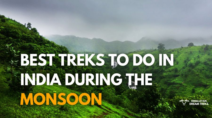
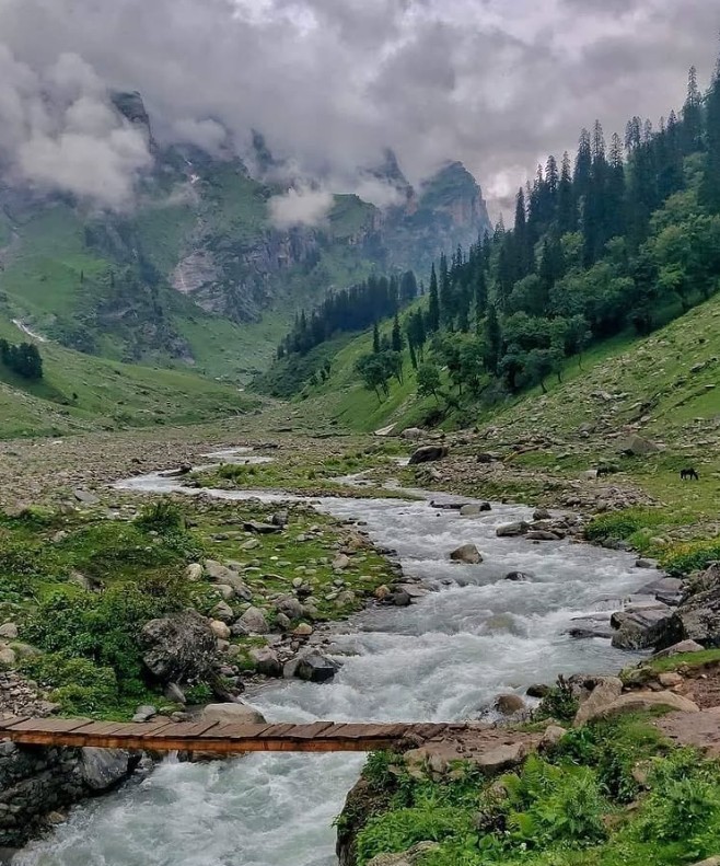
Imagine trekking through lush green trails, where every step treats you to the calming hum of rain, rustling of leaves, and the sound of gushing waterfalls. The smell of wet earth wafts through the air and mist wraps you in a hug – that is the beauty on Monsoon Treks, where adventure meets wonder. Get ready to experience standing on top of a cloud-kissed summit, watching nature reveal its magical beauty.
If you’re ready to escape the usual and dive into an experience that will leave you wanting for more, Monsoon treks is the answer. In this blog, we put together the best Monsoon treks in India, from the most sought-after Valley of Flowers trek, to the challenging Harishchandragad trek and the lesser known but equally breathtaking Dzongri trek. Whether you’re a beginner or a seasoned trekker, we have the perfect trek to match your experience level.
1. Valley Of Flowers Trek
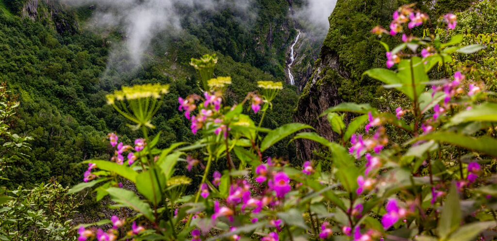
Valley of Flowers trek has found its place on most trekking maps for all the right reasons! It is beautiful and treats you to a carpet of flowers, as the name suggests. The valley is in full bloom during July to September, making it one of the best Monsoon treks in Uttarakhand. It is home to more than 400 species of flowers like the famous Brahma Kamal, Himalayan Poppy, Himalayan Cobra Lily, Himalayan Thyme, Evening Primrose and many more, that will fill up your eyes and camera too.
| Attributes | Details |
| Region | Chamoli District, Uttarakhand |
| Duration | 6 Days |
| Difficulty Level | Moderate |
| Maximum Altitude | 12,140 ft (VOF) & 14,160 ft (Hemkund Sahib) |
| Trekking Distance | 34 km |
| Terrain Type | Forest paths, Meadows, River crossings |
| Starting from | Pulna |
| Peaks Visible | Nilgiri, Rataban, Gauri Parvat |
| Suitable For | Beginners with good fitness, Experienced Trekkers, Photographers, Florist |
| Nearest Town/City | Joshimath |
Highlights of the Trek:
The popular route to reach here is a drive from Haridwar or Rishikesh to Govindghat and then a local taxi to Pulna along scenic views (alternatively you can start the trek from Govindghat too, which adds 5 km to the trek). A 9 km trek from there takes you to Ghangaria village, the last human habitation in the valley.
The final stretch of 6 km takes you to Valley of Flowers where the magic blooms, with beautiful views of the wildflowers. You can start your descent from the Valley or continue to trek 6 km to Hemkund Sahib, the highest Gurudwara in the world, and come back to Ghangaria.
Not only is it home to flowers, but also animals like Black Deer, Blue Sheep, Musk Deer, Red Fox, and birds like the Himalayan Monal. So, if you are a wildlife enthusiast or a birder, you are in for a treat!
Also, did you know that this valley was discovered by Frank Smythe after they lost their way returning from Mt. Kamet. He later wrote a book about it.
2. Harishchandragad Trek
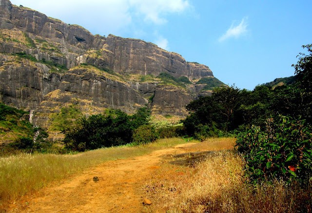
If you want to witness the Konkan Kada in all its glory, Harishchandragad Fort Trek is the right pick for you. Also if luck is on your side, then you can experience cloud bursts and circular rainbows.
| Attributes | Details |
| Region | Ahmednagar district, Maharashtra |
| Duration | 2 Days |
| Difficulty Level | Moderate to Difficult |
| Maximum Altitude | 4,670 ft |
| Trekking Distance | 14 km |
| Terrain Type | Rocky, forested paths, and steep climbs |
| Starting from | Khireshwar |
| Peaks Visible | Taramati Peak, Naneghat |
| Suitable For | Experienced trekkers, Adventure seekers |
| Nearest Town/City | Kalyan |
There are many trails to reach the fort. But the most common one is from Khireshwar, and is for trekkers with prior experience. But if you are a beginner, take the trail from Pachnai. However, the trails from Walhivale village are very challenging and are best attempted only with proper climbing equipment.
The trek starts from walking 5 km from Khubi Phata along the Pimpalgaon dam. From here the forest section takes you to Tolar Khind, along many small streams. From here the trail takes you to the Harishchandragad Top. There are steep climbs here, don’t tell us we didn’t caution you.
Explore the fort, and its historical sights like Saptateertha Pushkarni, Kedareshwar cave, and Harishchandreshwar temple.
You can choose to camp at the fort and visit Taramati Peak the following day, and admire the early misty morning views of the Konkan Valley.
3. Kudremukha Trek
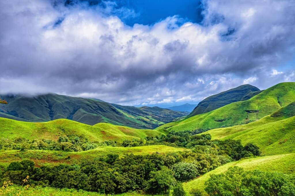
The Western Ghats in the monsoon is straight out of a wonderland. Kudremukha trek is one such beautiful tale. The name of this peak translates to horse’s face, owing to the shape of the mountain.
| Attributes | Details |
| Region | Dense forests, grasslands, and swamps |
| Duration | 2 Days |
| Difficulty Level | Easy to Moderate |
| Maximum Altitude | 6,214 ft |
| Trekking Distance | 20 km |
| Terrain Type | Dense forests, grasslands, swamps |
| Starting from | Mullodi Village |
| Peaks Visible | Kudremukh Peak, Baalebare Hill |
| Suitable For | Beginners and Experienced trekkers, Families |
| Nearest Town/City | Kalasa |
This peak is the third highest in Karnataka, the trail takes you through lush green forests, expansive grasslands, streams and waterfalls. The Western Ghats are known for their rich biodiversity, and Kudremukh is no exception. Keep an eye out for the Lion-Tailed Macaque and the Indian Giant Squirrel.
To start the trek, you need to reach the Mullodi Village from Kalasa by hiring a jeep. You are required to take a permission from the forest office at the entrance here. The Forest department has made it mandatory for trekkers to have a guide (they will assign you one).
The first 5 km leg of the trek is from the forest office to Ontimara, and then another 4 km to the high grasslands and the final stretch of 1 km to the peak. It is best to start the descent by 1 pm.
The following day you can see the impressive Kodige waterfalls, and other sights like Horanadu Temple, Ballarayanadurga Fort.
Karnataka is truly an underrated gem, which has many beautiful treks. You could consider other treks like Mullayanagiri, Kodachadri and Netravati.
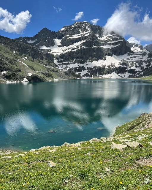
4. Tarsar Marsar Trek
Kashmir, as we all have heard of, is Paradise on Earth. Tarsar and Marsar, are two pristine lakes in that paradise. Nestled amidst snow-capped peaks in Kashmir, this trek to an untouched beauty is undoubtedly the best. With Kashmir Great Lakes trek gathering all the rightful attention, this trek is also slowly making its way on trekkers’ maps.
| Attributes | Details |
| Region | Anantnag district, Kashmir |
| Duration | 7 Days |
| Difficulty Level | Moderate |
| Maximum Altitude | 13,165 ft |
| Trekking Distance | 48 km |
| Terrain Type | Meadows, Grasslands, Glacial Moraine |
| Starting from | Aru |
| Peaks Visible | Mount Harmukh, Krishansar Peak |
| Suitable For | Beginners and Experienced trekkers |
| Nearest Town/City | Srinagar |
Kashmir receives less rainfall in July and August, compared to its counterparts, making this the most comfortable trek during the monsoon season. The Alpine lakes are in its full glory, showing off their deepest blue hues.
The trek starts from Aru, to which you will have to reach from Srinagar in private transportation. The first morning of the trek is rather easy, with 10 km taking you from Aru to Lidderwat, where you can see Gujjar huts.
It then progresses to the Tarsar Lake via Shekwas. Shekwas is an excellent camping ground to relax your muscles after a hard day’s climb.
The next section takes you from Sundersar to Marsar via Homwas. The Jagmargi meadows feel like a fairytale, the one you wish never ends. From Honwas you descend and reach the base at Aru.
These alpine lakes have a mystic charm and this experience is bound to leave you speechless!
5. Dzongri Trek
Sikkim, where nature smiles. This trek in Sikkim will leave you smiling too. Does walking through rhododendron blossoms and immersing in views of majestic peaks sound exciting to you? Then Dzongri trek is your answer. Tucked away in the Kanchenjunga National Park in a state that is bordered by China, Nepal and Bhutan, this makes for an offbeat monsoon trek in the country.

| Attributes | Details |
| Region | Yuksom, Sikkim |
| Duration | 7 Days |
| Difficulty Level | Moderate to Difficult |
| Maximum Altitude | 13,650 ft |
| Trekking Distance | 42 km |
| Terrain Type | Forest trails, Meadows, Alpine ridges, Rocky paths |
| Starting from | Yuksom |
| Peaks Visible | Mt. Kanchenjunga, Mt. Pandim, Mt. Jopuno |
| Suitable For | Experienced Trekkers |
| Nearest Town/City | Yuksom |
The average trekking distance on each day of this trek is about 8-9 km. On the first day you will start your climb from Yuksom to Sachen with an altitude gain of 5,840 ft. Over the next two days, the trail goes from Sachen to Tshoka and then to the Dzongri Top.
At the summit, you will be rewarded with breathtaking views of Mt. Kanchenjunga, which is the highest mountain in India, and Mt. Pandim.
This trek will also give you a peek into the cultural heritage of the North-East region and a chance to cross paths with the Lepcha and Bhutia communities.
The region is a part of the Important Bird Area Network, giving you a chance to spot species like Tragopan pheasants, Blood pheasants, Tibetan Horned owl, Hill Partridge, Forest Eagle.
Be informed that a trekking permit is required inside Kanchendzongha National Park and local police verification at Yuksom police outpost. Foreign nationals will additionally need an Inner Line Permit.
6. Hampta Pass Trek
Hampta pass is set between contrasting landscapes, the lush green valley of Kullu and the dry, barren terrain of Lahaul. As you ascend through alpine forests and cross glacial streams, you are welcomed with diverse landscapes. As the air grows thinner, views of various peaks unveil their grandeur.
| Attributes | Details |
| Region | Kullu District, Himachal Pradesh |
| Duration | 6 Days |
| Difficulty Level | Moderate |
| Maximum Altitude | 14,070 ft |
| Trekking Distance | 26 km |
| Terrain Type | Alpine meadows, Rocky paths, Glaciers, River crossings |
| Starting from | Jobra |
| Peaks Visible | Indrasen Peak, Deo Tibba, Mt. Hanuman Tibba |
| Suitable For | Experienced Trekkers |
| Nearest Town/City | Manali |
The trek begins from Jobra to Jwara, leading to Balu ka Ghera covering a distance of 10 km, over two days. In the next stretch you will head to Shea Goru via Hampta Pass trekking 8 km. The last leg is to reach Chhatru climbing 7km and then the descent begins.
At the Jobra meadow is a serene river Rani Nallah lined with marigolds and blue poppies. Take your time to slow down here soaking in the mountain views behind. Chikka and Jwara, offer stunning views of the Dhauladhar range and Pir Panjal Range.
Balu Ka Ghera is a great camping spot, take the time to rest and watch the sky turn red and orange as the sun goes down behind Hanuman Tibba Peak.
The ascent to Hampta Pass is challenging, involving a steep climb. But, as they say, the best view comes after the hardest climb – at 14,000 ft, you will see Deo Tibba Peak.
The trail is lined with trees like Pine, Maple, Deodar and colourful wildflowers. The region is home to several species of wildlife, including shepherd dogs, sheep, and Himalayan birds like the whistling thrush and white-capped redstart.
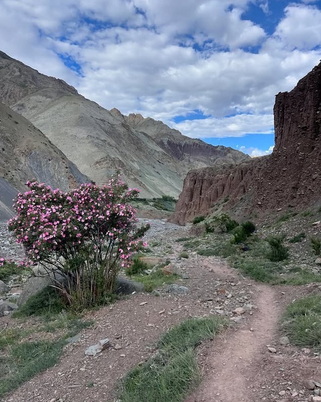
7. Markha Valley Trek
Located in Ladakh, Markha Valley is the largest in the region. This trek passes through Indus and Markha regions, and during monsoon, the stream crossings make it more beautiful. This trek is for those seeking extreme adventure as it covers more trekking distance each day and at very high altitudes.
| Attributes | Details |
| Region | Markha, Ladakh |
| Duration | 6 Days |
| Difficulty Level | Moderate to Difficult |
| Maximum Altitude | 16,732 Ft |
| Trekking Distance | 65 km |
| Terrain Type | Riverbeds, Rocky Paths, Glacial Terrain |
| Starting from | Chilling |
| Peaks Visible | Kang Yatse, Stok Kangri |
| Suitable For | Extreme Adventure Seekers, Trekkers with previous experience of high altitude treks |
| Nearest Town/City | Leh |
Kickstart the trek by crossing the mighty Zanskar river on the footover bridge, into Chilling. The trek begins from here to Skiu Village. After which you will trek through barley fields, cross the Markha River twice, and reach Markha village, the highest village in the valley. On the third day you will see the magical Kang Yatse Peak, so striking that you cannot miss it.
As you reach Hankar village you will notice how these villages serve a dash of green in a dry desert, making it feel like an oasis in the desert. From Hankar, the trek continues to Nimaling and then to Kongmaru La. The descent begins from Chokdo to Shang Sumdo and ends at returning to the civilisation at Leh.
Trekking in Ladakh is difficult, given that the name means ‘the land of high passes’. It is a high altitude region, with Leh standing at 11,560 Ft. Be sure to be well acclimatized before you start the trek.
You can end the trek by pairing a visit to the Hemis Monastery.
Bonus: How can we not talk about Meghalaya when we talk about monsoons! The Living Root Bridges hike is a wonderful option to consider. These Bridges in Nongriat village are an example of the beautiful coexistence of humans and nature. The Khasi people built these bridges out of the tree roots, without disturbing the ecological harmony. The hike starts from the village with descending down a flight of 3,500 stairs.
What to Keep in Mind for Monsoon Treks
Monsoon trekking is adventurous but also brings its share of challenges in the form of including slippery trails and unpredictable weather. Here’s how you can be better prepared.
- Appropriate Clothing: A waterproof jacket, quick-dry clothes, poncho (Rain cover) are teh basic essentials. And Gaiters to help from water and mud from seeping into your shoes, especially if you’re trekking in muddy or flooded areas.
- Proper Trekking Shoes: Make sure your trekking shoes are waterproof and have a strong grip to handle slippery conditions. Look for shoes designed for rugged terrain with rubber soles that can prevent slippage on wet rocks.
- Leech Protection: Apply leech-repellent creams on your legs or wear leech socks especially in forested areas.
- Prepare for Slippery Trails: Avoid venturing off marked paths, as the terrain can become unstable during the rains. Take shorter steps, and use trekking poles for better balance. Watch out for the weather forecasts.
- High Altitudes: Altitude sickness is no joke, please acclimatize well. Cover yourself in appropriate layering, make sure to have thermal wear for the cold and light clothing for the warmer, wetter moments. Stay hydrated at all times.
- Know When to Turn Back: If rivers or streams become too dangerous to cross, or if you encounter fast-flowing water during crossings, turn back to find a safer route or camp for the night. You can always do it the next time!
Leave a Comment